Upper Excelsior Falls via FLT in Burdett, New York is an easy 0.9-mile out-and-back hike that leads to a 10-foot tall waterfall, Upper Excelsior Falls.
The Finger Lakes Trail leads into the forest, passing some overgrowth, before the forest floor opens with less dense undergrowth as you approach Excelsior Gorge. The trail then leads uphill and around the top of the gorge before the FLT crosses Excelsior Creek. The hike up and around the gorge is the hardest part of this hike, but considering the up and downhill is not very long or difficult, it should be considered easy for most hikers.
After exploring Upper Excelsior Falls, hikers can choose to follow the FLT all the way down the gorge to reach NY-414 or they can hike back to parking via the route provided for a 0.9-mile out-and-back hike.
Exploring Excelsior Falls
Please note that the very large Excelsior Falls, located downstream from Upper Excelsior Falls, is not only on 100% private land, but also exists within super sketchy and dangerous terrain with cliffs and drop-offs that could spell disaster for off-trail trespassers. Please do not attempt to gain access to the large Excelsior Falls for various reasons, including trespassing and your own safety.
Trails
This hike follows one named trail: Finger Lakes Trail (white blazes). Note that the property surrounding the trail is private, so please stay on-trail.Hiking to Upper Excelsior Falls
This short hike begins along Jolly Road at an unmarked parking turnout for the Finger Lakes Trail (FLT). The property owner, where the FLT runs south from Jolly Road, has graciously allowed hikers to use the FLT to explore -- as noted by the posted signs at the trailhead. Please respect the land owner's rights and stay-on trail while exploring here.The Finger Lakes Trail leads into the forest, passing some overgrowth, before the forest floor opens with less dense undergrowth as you approach Excelsior Gorge. The trail then leads uphill and around the top of the gorge before the FLT crosses Excelsior Creek. The hike up and around the gorge is the hardest part of this hike, but considering the up and downhill is not very long or difficult, it should be considered easy for most hikers.
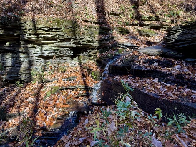
Upper Excelsior Falls - Mile 0.46
As the trail leads back downhill, before crossing the creek, it leads to a steep embankment that drops down to Excelsior Creek before crossing -- below your feet is Upper Excelsior Falls. This waterfall, while short, tumbles down the shale bedrock at approximately 10-feet tall. The safest view is from the top of the waterfall where the trail crosses the bedrock; however, if you're lucky and safe enough you can descend one rock ledge to get a nice view of the waterfall. Watch your step and explore at your own risk as the shale rock ledge could break away at any time under additional weight.After exploring Upper Excelsior Falls, hikers can choose to follow the FLT all the way down the gorge to reach NY-414 or they can hike back to parking via the route provided for a 0.9-mile out-and-back hike.
Exploring Excelsior Falls
Please note that the very large Excelsior Falls, located downstream from Upper Excelsior Falls, is not only on 100% private land, but also exists within super sketchy and dangerous terrain with cliffs and drop-offs that could spell disaster for off-trail trespassers. Please do not attempt to gain access to the large Excelsior Falls for various reasons, including trespassing and your own safety.