Trail names: Two Brooks Trail
Location: 478 - 498 Lyndeborough Road, Lyndeborough NH
Permitted uses: Hiking, nature study. Mountain biking, Horses, Cross country skiing are allowed on most PLC trails unless otherwise posted. During wet seasons, trails may be closed to prevent damage and erosion. We did not see any posting prohibiting these activities at the trailhead or on the Piscataquog Land Conservancy website (PLC).
https://plcnh.org/pic-public-use-policies/
Placing a Geocache and orienteering activities are generally allowed with advanced permission from PLC. There is one geocache placed in the park at the time of our visit. PLC generally allows hunting and fishing on their fee owned properties. Hunters and anglers must comply with all applicable State and Town hunting regulations. Visitors should exercise caution at all preserves during hunting season, regardless of whether hunting is allowed. Wearing blaze orange is recommended.
Prohibited uses: PLC prohibits the following activities at its preserves: Motorized vehicles,Removal, destruction, or disturbance of plants, wildlife, minerals, and cultural or historical resources. Camping and fires,Trapping, baiting, or feeding wildlife. Technical climbing,War and paintball games,Target shooting,Metal detecting Hours: There are no hours posted at the trailhead or on the PLC website.
Fees and Parking: There is no fee to park or use the trail. There is very limited parking that is a short distance from the trailhead. Please make sure to pull completely off the road as this is a road used by very big dump trucks and the road doesn't have good visibility around the sharp corners near the trailhead entrance. Please use caution.
Pets: Dogs must be on a leash and controlled at all times. Dog waste must be bagged and removed. Dogs can cause alarm to wildlife, so dogs must be kept from chasing or disturbing wildlife and other trail users.
Accessibility: The trail is not wheelchair accessible.
Hiker amenities: The Alan and Edgar Rice Natural Area is a 15 acre parcel owned and stewarded by the Piscataquog Land Conservancy (PLC). The road leading to the trailhead is not maintained in the winter and could also be undriveable in early spring. There is a trailhead sign at the entrance of the trail with a small black mailbox attached to the post. Inside the mailbox is a hiker log to register your visit as well as Trail guides for hikers to take along with them. The guide has a map along with 8 points of interest for hikers to learn about as they make their way along the trail. The pictures in the guide and the write up are really great. Make sure to take a guide with you and stop at all 8 points. There is no information kiosk but there is a large map posted along with a QR code and a posted internet website to access information about allowed activities in the Nature Area. Hikers can also download the trail guide and map before their visit by going to the PLC website at :
https://plcnh.org/rice-preserve-trail/
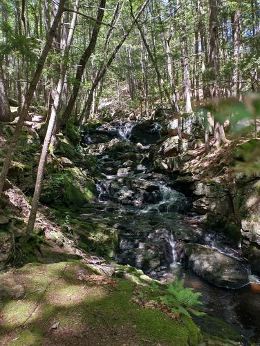
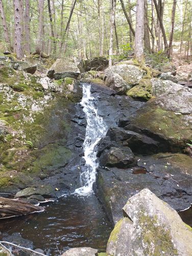
There are no restrooms or trash bins. Please carry out all the trash you create or find. Length and Trail information: This hike is an easy hike done as a loop and is roughly .44 of a mile in length. The trail is blazed well and often by blue diamond markers. The trail substrate is very much like many forest trails with tree debris and roots to navigate. There are no rock scrambles. The trail is narrow, so hikers will be traveling single file. There is a wooden footbridge that crosses over the Scataquog Brook. The Scataquog Brook is the first of the two brooks of the Two Brooks Trail. The trail leads hikers along the Brook to the foot of a large glacial drumlin. The trail begins to ascend and just when the steady climb starts your heart pumping, the trail turns on a switchback and the climb becomes less severe.There are also stairs installed in a couple sections of the trail to assist hikers with the climb up (or down) the side of the steeper sections. These glacial drumlins were created an estimated 15,000 years ago by retreating glacial waters. There are wooden fortifications installed along the trail to help keep the trail from eroding down the steep side of the hill. The trail is narrow in these sections and caution should be used in case the soil has shifted. The trail brings hikers to one of the highlights of the trail; the beautiful cascades at Senter Falls along the Cold Brook. Cold Brook is the second of the two trails named on this Two Brooks Trail. It’s hard to describe just how massive this rocky gorge is and even harder to capture in a photo. Hikers are encouraged to stay on the trail and not be tempted to enter the Cold Brook as the rocks can be slippery and soil erosion is possible. Please heed the warning and stay on the trail. The trail makes its way down the drumlin and through a large outwash plain, then back to the footbridge to head back up to Lyndeborough Road. Although this is a very short hike, and could be hiked fairly quickly, I would encourage all visitors to take advantage of the trail guide and stop to learn about the Natural Area at each of the 8 points of interest. The guide is well written and educational. For instance, before this hike, I had no idea what a glacial drumlin or an outwash plain was, but now I do. We thoroughly enjoyed this lovely spot and hope you will too.
Location: 478 - 498 Lyndeborough Road, Lyndeborough NH
Permitted uses: Hiking, nature study. Mountain biking, Horses, Cross country skiing are allowed on most PLC trails unless otherwise posted. During wet seasons, trails may be closed to prevent damage and erosion. We did not see any posting prohibiting these activities at the trailhead or on the Piscataquog Land Conservancy website (PLC).
https://plcnh.org/pic-public-use-policies/
Placing a Geocache and orienteering activities are generally allowed with advanced permission from PLC. There is one geocache placed in the park at the time of our visit. PLC generally allows hunting and fishing on their fee owned properties. Hunters and anglers must comply with all applicable State and Town hunting regulations. Visitors should exercise caution at all preserves during hunting season, regardless of whether hunting is allowed. Wearing blaze orange is recommended.
Prohibited uses: PLC prohibits the following activities at its preserves: Motorized vehicles,Removal, destruction, or disturbance of plants, wildlife, minerals, and cultural or historical resources. Camping and fires,Trapping, baiting, or feeding wildlife. Technical climbing,War and paintball games,Target shooting,Metal detecting Hours: There are no hours posted at the trailhead or on the PLC website.
Fees and Parking: There is no fee to park or use the trail. There is very limited parking that is a short distance from the trailhead. Please make sure to pull completely off the road as this is a road used by very big dump trucks and the road doesn't have good visibility around the sharp corners near the trailhead entrance. Please use caution.
Pets: Dogs must be on a leash and controlled at all times. Dog waste must be bagged and removed. Dogs can cause alarm to wildlife, so dogs must be kept from chasing or disturbing wildlife and other trail users.
Accessibility: The trail is not wheelchair accessible.
Hiker amenities: The Alan and Edgar Rice Natural Area is a 15 acre parcel owned and stewarded by the Piscataquog Land Conservancy (PLC). The road leading to the trailhead is not maintained in the winter and could also be undriveable in early spring. There is a trailhead sign at the entrance of the trail with a small black mailbox attached to the post. Inside the mailbox is a hiker log to register your visit as well as Trail guides for hikers to take along with them. The guide has a map along with 8 points of interest for hikers to learn about as they make their way along the trail. The pictures in the guide and the write up are really great. Make sure to take a guide with you and stop at all 8 points. There is no information kiosk but there is a large map posted along with a QR code and a posted internet website to access information about allowed activities in the Nature Area. Hikers can also download the trail guide and map before their visit by going to the PLC website at :
https://plcnh.org/rice-preserve-trail/
There are no restrooms or trash bins. Please carry out all the trash you create or find. Length and Trail information: This hike is an easy hike done as a loop and is roughly .44 of a mile in length. The trail is blazed well and often by blue diamond markers. The trail substrate is very much like many forest trails with tree debris and roots to navigate. There are no rock scrambles. The trail is narrow, so hikers will be traveling single file. There is a wooden footbridge that crosses over the Scataquog Brook. The Scataquog Brook is the first of the two brooks of the Two Brooks Trail. The trail leads hikers along the Brook to the foot of a large glacial drumlin. The trail begins to ascend and just when the steady climb starts your heart pumping, the trail turns on a switchback and the climb becomes less severe.There are also stairs installed in a couple sections of the trail to assist hikers with the climb up (or down) the side of the steeper sections. These glacial drumlins were created an estimated 15,000 years ago by retreating glacial waters. There are wooden fortifications installed along the trail to help keep the trail from eroding down the steep side of the hill. The trail is narrow in these sections and caution should be used in case the soil has shifted. The trail brings hikers to one of the highlights of the trail; the beautiful cascades at Senter Falls along the Cold Brook. Cold Brook is the second of the two trails named on this Two Brooks Trail. It’s hard to describe just how massive this rocky gorge is and even harder to capture in a photo. Hikers are encouraged to stay on the trail and not be tempted to enter the Cold Brook as the rocks can be slippery and soil erosion is possible. Please heed the warning and stay on the trail. The trail makes its way down the drumlin and through a large outwash plain, then back to the footbridge to head back up to Lyndeborough Road. Although this is a very short hike, and could be hiked fairly quickly, I would encourage all visitors to take advantage of the trail guide and stop to learn about the Natural Area at each of the 8 points of interest. The guide is well written and educational. For instance, before this hike, I had no idea what a glacial drumlin or an outwash plain was, but now I do. We thoroughly enjoyed this lovely spot and hope you will too.