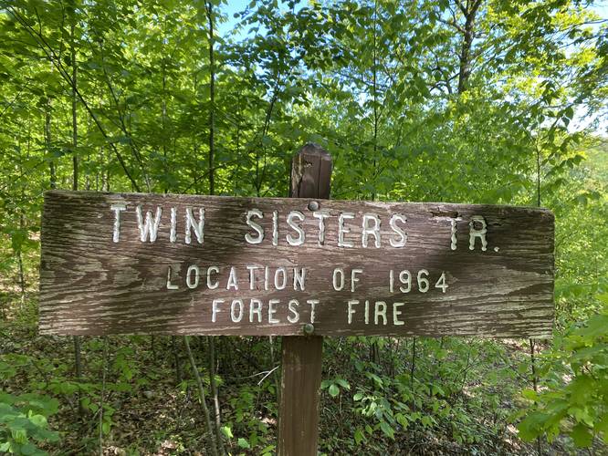
This section of the Twin Sisters Trail at the Hammersley Wild Area near Austin, Pennsylvania is an easy to moderate 4.3-mile out-and-back hike that leads to a beautiful vista point created by a wildfire back in 1964.
Trail Location
This trail lies within the Hammersley Wild Area which also is part of the Susquehannock State Forest. A map of Hammersley Wild Area can be found here:
http://www.docs.dcnr.pa.gov/cs/groups/public/documents/document/Hammersley_brochure_2019-04-10.pdf
Trail Description
The entirety of the Twin Sisters Trail is much longer than this recording; however, this hike is 2.2-miles one-way and ends just south of Elk Lick Knob at the vista point.
Hikers will find the trailhead does not have a sign or blaze near it, so during the warmer months, the trail can be a bit difficult to spot from the parking area -- generally, just look to the right-hand side if facing the parking lot from the road and you will find the trail.
The trail begins by gradually heading uphill following orange blazes. The terrain of the trail is gradually flat with no brush or overgrowth to push through. The surround terrain is a bit different - hikers will notice the forest floor is covered in what look like depressions and pockets in the earth. These depressions are from old tree stumps and roots that once dominated the forest floor but were cut down by logging companies prior to the early 1900's. Today the forest floor undulates because of these long-lost trees.
Beyond the first small hill the trail will flatten out and undulate a bit before running along a ridge with some trees that people once carved into back in the 1970's. Please do not carve into the trees, but rather think about all of the people that have once past through along the Twin Sisters Trail.
Not long after the trail has been running for a flat distance, it'll head back uphill while it climbs Elk Lick Knob. If following an offline GPS map, hikers will notice the trail continues to climb Elk Lick Knob even near the northern section of the summit. On the state forest map, it appears to be much flatter.
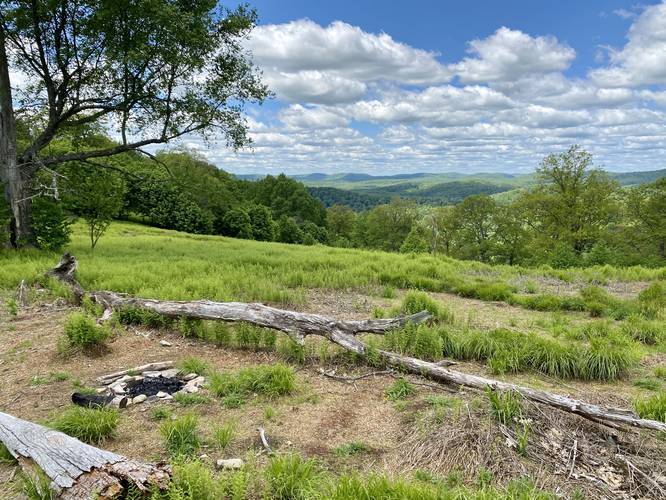
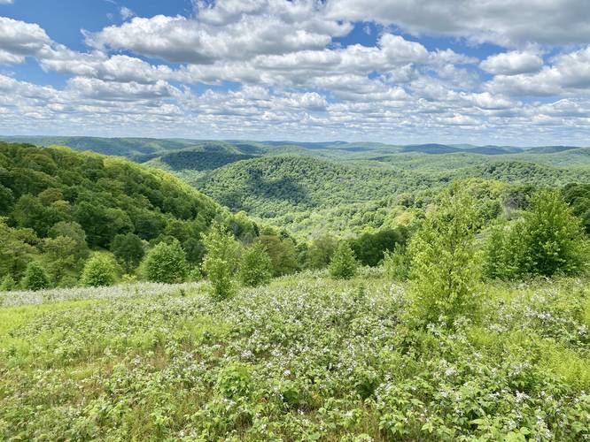
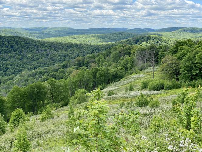
As you hike around the western side of Elk Lick Knob, hikers will finally reach the vista point which was created by a wildfire in 1964. The wildfire scar sits on the southwestern side of Elk Lick Knob summit and spans an area of about 0.15-miles one-way. The vista point has several locations to sit down and enjoy the view; however, most of the flora in this section of the trail are blackberry bushes, some blueberry, and other low-growing scrubland brush. During the late Spring just before Summer, the blackberries can be found blooming which makes this vista even more stunning.
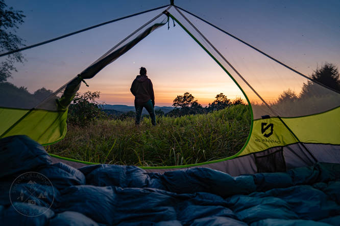
At the southern end of the wildfire scar vista area is a pre-built campsite near a large tree. In June 2020 there was a fire ring setup as well. You can also hike up the hillside here and setup camp within the low-growing brush to get an even better view.
The hike out is much easier than the hike in, but there is at least one uphill section which is not difficult. Overall this hike should be considered easy to moderate at worst, hence the 'moderate' difficulty.
1964 Wildfire Scar Vista Point
The Hammersley Wild Area is almost exclusively forested except for four natural gas pipelines and this wildfire scar which was leftover from a wildfire in 1964.
Parking
Hikers can find parking at the coordinates provided and the lot is large enough to fit about four vehicles. Be aware that the parking area is mostly grass and can be muddy.
Pets
Dogs are allowed if leashed.
Backpacking and Camping
Backpackers must follow the state forest rules and regulations for dispersed / primitive / backcountry camping in Susquehannock State Forest and the Hammersley Wild Area.
Water
Hikers must note that this is a ridge hike - meaning there are no water sources along the trail. Pack in all of your water and plan for as many days as you need if you are planning to backpack the Hammersley Wild Area ridges.
Blaze Color
The state forest map has this labeled as a yellow blaze, which it used to be. It was recently repainted / reblazed orange, at least from the north trailhead to the vista / wildfire scar.
Trail Location
This trail lies within the Hammersley Wild Area which also is part of the Susquehannock State Forest. A map of Hammersley Wild Area can be found here:
http://www.docs.dcnr.pa.gov/cs/groups/public/documents/document/Hammersley_brochure_2019-04-10.pdf
Trail Description
The entirety of the Twin Sisters Trail is much longer than this recording; however, this hike is 2.2-miles one-way and ends just south of Elk Lick Knob at the vista point.
Hikers will find the trailhead does not have a sign or blaze near it, so during the warmer months, the trail can be a bit difficult to spot from the parking area -- generally, just look to the right-hand side if facing the parking lot from the road and you will find the trail.
The trail begins by gradually heading uphill following orange blazes. The terrain of the trail is gradually flat with no brush or overgrowth to push through. The surround terrain is a bit different - hikers will notice the forest floor is covered in what look like depressions and pockets in the earth. These depressions are from old tree stumps and roots that once dominated the forest floor but were cut down by logging companies prior to the early 1900's. Today the forest floor undulates because of these long-lost trees.
Beyond the first small hill the trail will flatten out and undulate a bit before running along a ridge with some trees that people once carved into back in the 1970's. Please do not carve into the trees, but rather think about all of the people that have once past through along the Twin Sisters Trail.
Not long after the trail has been running for a flat distance, it'll head back uphill while it climbs Elk Lick Knob. If following an offline GPS map, hikers will notice the trail continues to climb Elk Lick Knob even near the northern section of the summit. On the state forest map, it appears to be much flatter.
As you hike around the western side of Elk Lick Knob, hikers will finally reach the vista point which was created by a wildfire in 1964. The wildfire scar sits on the southwestern side of Elk Lick Knob summit and spans an area of about 0.15-miles one-way. The vista point has several locations to sit down and enjoy the view; however, most of the flora in this section of the trail are blackberry bushes, some blueberry, and other low-growing scrubland brush. During the late Spring just before Summer, the blackberries can be found blooming which makes this vista even more stunning.
At the southern end of the wildfire scar vista area is a pre-built campsite near a large tree. In June 2020 there was a fire ring setup as well. You can also hike up the hillside here and setup camp within the low-growing brush to get an even better view.
The hike out is much easier than the hike in, but there is at least one uphill section which is not difficult. Overall this hike should be considered easy to moderate at worst, hence the 'moderate' difficulty.
1964 Wildfire Scar Vista Point
The Hammersley Wild Area is almost exclusively forested except for four natural gas pipelines and this wildfire scar which was leftover from a wildfire in 1964.
Parking
Hikers can find parking at the coordinates provided and the lot is large enough to fit about four vehicles. Be aware that the parking area is mostly grass and can be muddy.
Pets
Dogs are allowed if leashed.
Backpacking and Camping
Backpackers must follow the state forest rules and regulations for dispersed / primitive / backcountry camping in Susquehannock State Forest and the Hammersley Wild Area.
Water
Hikers must note that this is a ridge hike - meaning there are no water sources along the trail. Pack in all of your water and plan for as many days as you need if you are planning to backpack the Hammersley Wild Area ridges.
Blaze Color
The state forest map has this labeled as a yellow blaze, which it used to be. It was recently repainted / reblazed orange, at least from the north trailhead to the vista / wildfire scar.