The Twin Cascade & Hoosac Tunnel hike in Florida, Massachusetts is a moderate 0.6-mile out-and-back hike that features the Hoosac Tunnel's east portal and features the 15-foot tall Lower Falls of Twin Cascade due to a landslide.
Landslide Notice / Partial Trail Closure
This track ends just before a large landslide along the Twin Cascade Trail, located around mile 0.3. Reaching Twin Cascade, as of December 2023, appears to be extremely dangerous and risky, hence why this GPS data stopped before reaching the main waterfall. The GPS data stops near a Lower Falls (approx. 15-feet tall) within Cascade Brook where hikers will find a nice view of this waterfall; however, going any further, passing through the landslide zone, is likely not a smart move.
Hike Description
This hike begins at the eastern portal for the Hoosac Tunnel, at the parking coordinates provided, and follows the northern side of the train tracks to reach a trail that runs up the south side of the nearby Cascade Brook. Hikers must be extra careful here as the train tracks are still active today -- do not walk on the tracks but rather up along the side of the embankment.
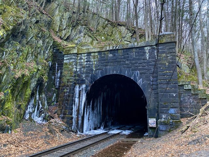
Hoosac Tunnel Eastern Portal - Mile 0.08
Right at the Hoosac Tunnel's eastern portal (built in 1877) is a hillside climb that leads out from the train track embankment and up to the trail that runs along Cascade Brook. Here, you can enjoy the Hoosac Tunnel from afar (do not enter or go near it).
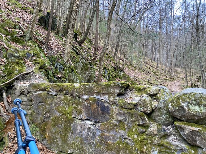
5-foot Scramble - Mile 0.1
Around mile 0.1, in order to continue hiking the trail, you must scramble up a 5-foot wall to reach the other side. This scramble is not difficult but will slow you down. Here, the real hiking begins as the trail leads up the mountain hollow following extremely-steep ravine mountainsides.
The trail leads up along Cascade Brook along a fairly skinny and sketchy-feeling trail. The hillsides are super steep and plunge down for dozens of feet to the brook below, so watch your step.
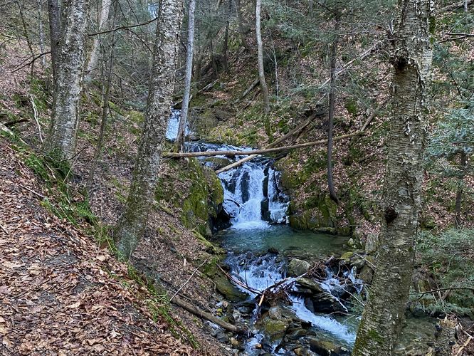
Lower Twin Cascade Falls, approx. 15-feet tall - Mile 0.3
Around mile 0.3, hikers will reach a viewpoint of the ~15-foot tall Lower Twin Cascade Falls (maybe not the best name), which is a single waterfall that cascades over bedrock within Cascade Brook at about 15-feet high.
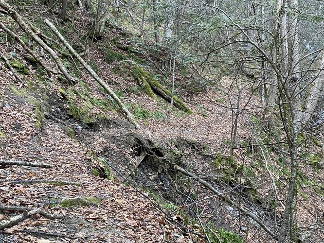
Landslide / Trail Closed - Mile 0.31
Upon our hike here, it had recently rained heavily with additional rain coming down on us -- I had just thought about how steep the terrain was and how a landslide could occur here easily -- then I looked at the trail ahead and noticed a massive landslide. The landslide took out the trail entirely with just a small part of the ground remaining. Neither of us were willing to risk our lives to view Twin Cascade, so we hiked out here. Anyone looking to hike to Twin Cascade will be disappointed as this trail is extremely unsafe and doing so will put your own life at risk by crossing unstable soil within a landslide zone.
After exploring the trail and seeing the Lower Falls in Cascade Brook, hikers will head out and back down the trail to reach parking. Remember to be extra careful near the train track embankment and do not go near the tracks, tunnel, and always stay out of the Hoosac Tunnel.
Parking
Hikers will find a large parking lot at the coordinates provided, located on River Road in Florida, MA. The lot is large enough to fit a couple dozen vehicles.
Pets
Dogs are allowed if leashed and must be cleaned up after. Note that the 5-foot wall scramble might make it hard for your dog to hike here.
Warning
Active train tracks: The train tracks that run adjacent to the entrance trail are active. Do not go on or cross them and always stay up on the embankment far away from the tracks. Listen for trains and do not trespass into the Hoosac Tunnel.
Steep terrain: This trail follows a mountain hollow ravine with extremely-steep hillsides. One false move could mean you slide down the mountain for dozens of feet, causing serious injury or worse.
Landslide: As stated several times, as of December 2023 (or earlier) there's a massive landslide located on-trail that wiped out a good portion of the trail. Reaching Twin Cascade is not smart and thus this write-up exists to help hikers understand what the current trail conditions are. Hike at your own risk and always over-evaluate risky and dangerous situations if attempting to hike in them.
Landslide Notice / Partial Trail Closure
This track ends just before a large landslide along the Twin Cascade Trail, located around mile 0.3. Reaching Twin Cascade, as of December 2023, appears to be extremely dangerous and risky, hence why this GPS data stopped before reaching the main waterfall. The GPS data stops near a Lower Falls (approx. 15-feet tall) within Cascade Brook where hikers will find a nice view of this waterfall; however, going any further, passing through the landslide zone, is likely not a smart move.
Hike Description
This hike begins at the eastern portal for the Hoosac Tunnel, at the parking coordinates provided, and follows the northern side of the train tracks to reach a trail that runs up the south side of the nearby Cascade Brook. Hikers must be extra careful here as the train tracks are still active today -- do not walk on the tracks but rather up along the side of the embankment.
Hoosac Tunnel Eastern Portal - Mile 0.08
Right at the Hoosac Tunnel's eastern portal (built in 1877) is a hillside climb that leads out from the train track embankment and up to the trail that runs along Cascade Brook. Here, you can enjoy the Hoosac Tunnel from afar (do not enter or go near it).
5-foot Scramble - Mile 0.1
Around mile 0.1, in order to continue hiking the trail, you must scramble up a 5-foot wall to reach the other side. This scramble is not difficult but will slow you down. Here, the real hiking begins as the trail leads up the mountain hollow following extremely-steep ravine mountainsides.
The trail leads up along Cascade Brook along a fairly skinny and sketchy-feeling trail. The hillsides are super steep and plunge down for dozens of feet to the brook below, so watch your step.
Lower Twin Cascade Falls, approx. 15-feet tall - Mile 0.3
Around mile 0.3, hikers will reach a viewpoint of the ~15-foot tall Lower Twin Cascade Falls (maybe not the best name), which is a single waterfall that cascades over bedrock within Cascade Brook at about 15-feet high.
Landslide / Trail Closed - Mile 0.31
Upon our hike here, it had recently rained heavily with additional rain coming down on us -- I had just thought about how steep the terrain was and how a landslide could occur here easily -- then I looked at the trail ahead and noticed a massive landslide. The landslide took out the trail entirely with just a small part of the ground remaining. Neither of us were willing to risk our lives to view Twin Cascade, so we hiked out here. Anyone looking to hike to Twin Cascade will be disappointed as this trail is extremely unsafe and doing so will put your own life at risk by crossing unstable soil within a landslide zone.
After exploring the trail and seeing the Lower Falls in Cascade Brook, hikers will head out and back down the trail to reach parking. Remember to be extra careful near the train track embankment and do not go near the tracks, tunnel, and always stay out of the Hoosac Tunnel.
Parking
Hikers will find a large parking lot at the coordinates provided, located on River Road in Florida, MA. The lot is large enough to fit a couple dozen vehicles.
Pets
Dogs are allowed if leashed and must be cleaned up after. Note that the 5-foot wall scramble might make it hard for your dog to hike here.
Warning
Active train tracks: The train tracks that run adjacent to the entrance trail are active. Do not go on or cross them and always stay up on the embankment far away from the tracks. Listen for trains and do not trespass into the Hoosac Tunnel.
Steep terrain: This trail follows a mountain hollow ravine with extremely-steep hillsides. One false move could mean you slide down the mountain for dozens of feet, causing serious injury or worse.
Landslide: As stated several times, as of December 2023 (or earlier) there's a massive landslide located on-trail that wiped out a good portion of the trail. Reaching Twin Cascade is not smart and thus this write-up exists to help hikers understand what the current trail conditions are. Hike at your own risk and always over-evaluate risky and dangerous situations if attempting to hike in them.