Loading...

🎉 Enjoy a Free 7-Day Supporter Trial and Unlock Exclusive Perks — No Credit Card Required. Learn more.

Tuolumne Meadows to Yosemite Valley

Directions
Map
Pictures
Send to App
Distance:
37.0 Miles / 59.5 km
Type:
One-Way
Difficulty:
Strenuous
Time to Hike:
18 hours, ~30 minutes
Features:
Surface Type:
Dirt
Park:
Yosemite National Park
Town:
Wawona, California
Directions:
37.877042, -119.352731
Added:
August 23, 2017
Updated:
November 27, 2017
Copy Trail Link Hiking this trail? Send a friend or family member a link to this trail guide for your own safety. Hike at your own risk (disclaimer)
Loading...
Loading...
5,920'

Total Change
5,451'

Ascent
9,911'

Descent

Download the Trail Route for Offline Use

Supporters get exclusive access to download trail routes to the MyHikes app for offline use. Stay prepared on your adventure, even without an internet connection! Become a Supporter today to unlock this feature and hike with confidence.

Send to App

Tuolumne Meadows to Yosemite Valley

This trip in Yosemite National Park is a strenuous 37 mile one-way backpacking route from Tuolumne Meadows to Yosemite Valley, crossing Half Dome on the way.

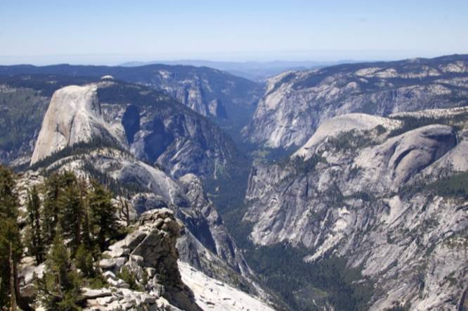
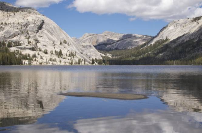
This trip took 5 days and 4 nights to complete with 5000 feet of elevation gain and 9000 feet total of descent and starts on the Glen Aulin Trail and meets up with the Sunrise Trail which leads to Sunrise Lakes and Clouds RestAfter making it to Clouds Rest, hike back to the Half Dome Trail and then down to Yosemite Valley on the Mist Trail. 

Red Tape: Overnight trips anywhere in Yosemite require a wilderness permit. The NPS website has plenty of helpful information on how to secure a permit. It can be a bit of a lottery, so it’s good to be flexible and make reservations well in advance. Additionally, hiking Half Dome now requires a permit 7 days per week. There is a lottery system for day hikers, but it’s also possible to secure a permit when reserving the backpacking permit. Once all permits are secured, it’s a good idea to reserve bus tickets from Yosemite Valley to Tuolumne Meadows. There is only one shuttle per day and it fills up! Information can be found on the DNC website. In the summer, it’s also possible to take YARTS. We did not have this option (weekday service hadn’t begun in June) so I didn’t really research it, but I do know YARTS is slightly cheaper than the DNC tour bus.

For more trip details, check out this NorCal Hiker blog post.

Explore 10 trails near Wawona, CA
  1. Parking

    37.877042, -119.352731
  2. Main Trailhead

    37.87736, -119.353666
  3. View from Clouds Rest

    37.76635, -119.49018
    View from Clouds Rest
  4. Tenaya Lake

    37.83017, -119.4678
    Tenaya Lake
No community routes found. To add your own hike as a Community Route for this Trail guide, leave a Trip Report with an attached GPX file.

Hazards

Ticks - Lyme Disease More Info (CDC)

Season

Summer

Photo Albums

Trip Reports

Trail Guide By:
Norcalhiker user profile picture
37.0 miles / 59.5 km

Weather Forecast

In Wawona, CA

Explore Hiking Trails

You May Also Like

Colorado's Million Dollar Highway - Plan a day's drive adventure along the iconic Million Dollar Highway in Colorado. Explore the best short trails, roadside stops, waterfalls, vistas, ghost towns, and hot springs within a ~6 hour road trip.
Explore

Colorado's Million Dollar Highway

Plan a day's drive adventure along the iconic Million Dollar Highway in Colorado. Explore the best short trails, roadside stops, waterfalls, vistas, ghost towns, and hot springs within a ~6 hour road trip.

Read
Glacier's Going-to-the-Sun Road - Discover the breathtaking beauty of Glacier National Park along the iconic Going-to-the-Sun Road. From stunning roadside stops to picturesque waterfalls and vistas, this engineering marvel offers endless opportunities for exploration.
Explore

Glacier's Going-to-the-Sun Road

Discover the breathtaking beauty of Glacier National Park along the iconic Going-to-the-Sun Road. From stunning roadside stops to picturesque waterfalls and vistas, this engineering marvel offers endless opportunities for exploration.

Read
New York's Best Waterfalls - Whether you're planning a day hike, roadside stop, or a leisurely short walk, this guide provides hikers, travelers, and locals alike with 63 different locations to over 100 scenic waterfalls to help plan your next adventure!
Explore

New York's Best Waterfalls

Whether you're planning a day hike, roadside stop, or a leisurely short walk, this guide provides hikers, travelers, and locals alike with 63 different locations to over 100 scenic waterfalls to help plan your next adventure!

Read

Before you boogie...

Find our trail guides useful? Consider becoming a Supporter to unlock perks!

MyHikes is an indie platform that makes exploring public trails easier for everyone. The platform has no investors, no ads, and is owned and operated by one person, Dave Miller. Dave has personally mapped and written over 1,800 trail guides on MyHikes for the public to explore. MyHikes has helped millions outdoor enthusiasts plan their next adventure.

But it takes a lot of time 🕦, money 💰, work, and espresso shots ☕ to run MyHikes, including hiking , mapping , writing , and publishing new trails with high-quality (accurate) information... along with software engineering (coding) the platform like building new features, website and mobile app development (iOS and Android), site maintainance . and much much more.

Supporters unlock website and mobile app perks with an annual one-time payment of $25 (you renew) 😎👍. Or you can simply make a Donation of your choice. Otherwise, you can support us by telling your friends about MyHikes - both quick and free 🎉

Admin user profile picture

Dave Miller
MyHikes Founder