The Tucker Brook Falls & Town Forest Loop hike at Tucker Brook Town Forest in Milford, New Hampshire is an easy 4.7-mile loop hike that features a beautiful waterfall, creek-side hiking, and glacial erratics.
Trail names: The Ridge Trail, The Powerline Connector, Jimmy's Run, The Fall's Loop, The Sidewinder, The Lower Path, The Forest Trail and the Brook Trail.
Location: Boulder Road, Tucker Brook Town Forest, Milford, NH
Permitted uses: Hiking, Mountain Biking, Birding, Horseback riding, Nature Study, Snowshoeing, Geocaching, Hunting
Prohibited uses: No Trash, no fires, no alcohol.
Hours: No posted hours
Fees and Parking: There is no fee to park or use the trails. Parking at Boulder Road does not have a designated parking lot and is limited to side of the road parking. Possibly, three cars could park on either side. This is a residential area, so please be mindful of where you park. The Trailhead is not very noticeable from the road. Be on the lookout for a small brown wooden sign with gold lettering posted on a tree near the trail entrance. There is a large parking area on Savage Road that has off street parking and offers a good amount of space for several cars and would even allow for a horse-trailer to fit. The trail entrance on Savage Road is off to the side of the parking near the utility pole, and the kiosk is further down the trail, so the trail is not very obvious from the parking area. Additionally, there is trail access on Whitten Road, but there is no safe parking here and the signage is not visible from the road. Our advice would be to park at either the large parking area on Savage Road, or the limited side street parking on Boulder Drive.
Pets: Dogs MUST be on a leash.
Accessibility: The trail is not wheelchair accessible
Sanitation: There is no restroom or trash bin at the trailhead or on the trails. Please carry out what you carry in.
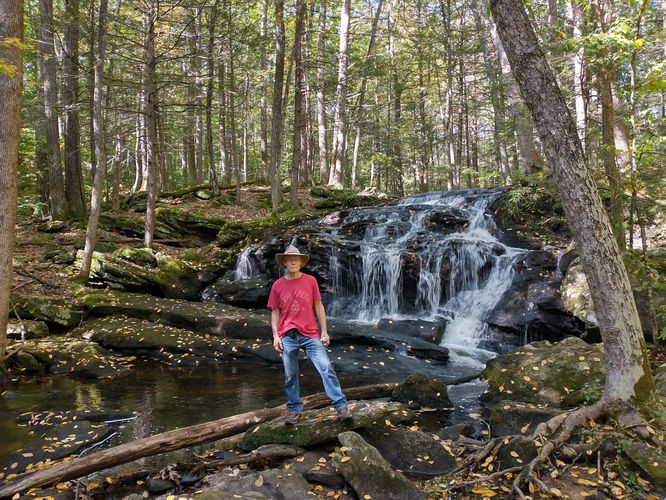
Length and Trail information: This 4.7-mile hike was done as a loop and was an easy hike. We accessed the trail system by parking on the side of the road at the Boulder Drive trailhead access. A few yards down the trail is a Trail information kiosk showing a map of the trails in the 285-acre Tucker Brook Forest. The forest falls under the stewardship of the Milford Conservation Commission. There are three trail blaze colors used within the trail system here: white is used for main trails, blue blazes are used for loops and side trails, and some trails are blazed in yellow. All the trails are named and numbered on the map; however, hikers will see neither trail names nor numbers posted along the trail itself, just trail blazes. That being said, the trails are very well blazed and there are maps posted at almost all of the trail junctions. The maze of trails allows hikers to visit several times and by switching up the trails in any given hike, they will enjoy a completely different hiking experience with each visit. There are lots of roots and rocks along the trail, as well as sections of wetness with some slippery rocks to be careful on. This is a well shaded forest with a variety of different trees and huge sections of mountain laurel, making this no doubt, a gorgeous hike during the late spring when the Mountain Laurel is in bloom. During our hike we were happy to hear and see lots of bird activity including Blue Jays, Chickadees, Rock doves and Robins. The area is a prime spot for mushroom foraging. During our visit we were able to find puffball, hedgehog, turkey tail and also several nice hericium mushrooms. Besides hiking, birding or foraging, there are also at least two geocaches within the boundary of the town forest that visitors can search for. Our goal during this hike was to visit the Tucker Brook Falls. Tucker Brook Falls are the highlight of this hike reported to be 12 feet high, having several shallow shelves down its face making the generously cascading water on our visit quite beautiful to see. Plan a bit of time to spend at this area, especially if you plan to cool off in the stream or in the falls themselves.
Trail names: The Ridge Trail, The Powerline Connector, Jimmy's Run, The Fall's Loop, The Sidewinder, The Lower Path, The Forest Trail and the Brook Trail.
Location: Boulder Road, Tucker Brook Town Forest, Milford, NH
Permitted uses: Hiking, Mountain Biking, Birding, Horseback riding, Nature Study, Snowshoeing, Geocaching, Hunting
Prohibited uses: No Trash, no fires, no alcohol.
Hours: No posted hours
Fees and Parking: There is no fee to park or use the trails. Parking at Boulder Road does not have a designated parking lot and is limited to side of the road parking. Possibly, three cars could park on either side. This is a residential area, so please be mindful of where you park. The Trailhead is not very noticeable from the road. Be on the lookout for a small brown wooden sign with gold lettering posted on a tree near the trail entrance. There is a large parking area on Savage Road that has off street parking and offers a good amount of space for several cars and would even allow for a horse-trailer to fit. The trail entrance on Savage Road is off to the side of the parking near the utility pole, and the kiosk is further down the trail, so the trail is not very obvious from the parking area. Additionally, there is trail access on Whitten Road, but there is no safe parking here and the signage is not visible from the road. Our advice would be to park at either the large parking area on Savage Road, or the limited side street parking on Boulder Drive.
Pets: Dogs MUST be on a leash.
Accessibility: The trail is not wheelchair accessible
Sanitation: There is no restroom or trash bin at the trailhead or on the trails. Please carry out what you carry in.
Length and Trail information: This 4.7-mile hike was done as a loop and was an easy hike. We accessed the trail system by parking on the side of the road at the Boulder Drive trailhead access. A few yards down the trail is a Trail information kiosk showing a map of the trails in the 285-acre Tucker Brook Forest. The forest falls under the stewardship of the Milford Conservation Commission. There are three trail blaze colors used within the trail system here: white is used for main trails, blue blazes are used for loops and side trails, and some trails are blazed in yellow. All the trails are named and numbered on the map; however, hikers will see neither trail names nor numbers posted along the trail itself, just trail blazes. That being said, the trails are very well blazed and there are maps posted at almost all of the trail junctions. The maze of trails allows hikers to visit several times and by switching up the trails in any given hike, they will enjoy a completely different hiking experience with each visit. There are lots of roots and rocks along the trail, as well as sections of wetness with some slippery rocks to be careful on. This is a well shaded forest with a variety of different trees and huge sections of mountain laurel, making this no doubt, a gorgeous hike during the late spring when the Mountain Laurel is in bloom. During our hike we were happy to hear and see lots of bird activity including Blue Jays, Chickadees, Rock doves and Robins. The area is a prime spot for mushroom foraging. During our visit we were able to find puffball, hedgehog, turkey tail and also several nice hericium mushrooms. Besides hiking, birding or foraging, there are also at least two geocaches within the boundary of the town forest that visitors can search for. Our goal during this hike was to visit the Tucker Brook Falls. Tucker Brook Falls are the highlight of this hike reported to be 12 feet high, having several shallow shelves down its face making the generously cascading water on our visit quite beautiful to see. Plan a bit of time to spend at this area, especially if you plan to cool off in the stream or in the falls themselves.