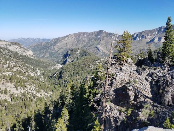
The Trail Canyon Trail to North Loop Trail at the Humboldt-Toiyabe National Forest in Mount Charleston, Nevada is a difficult 6.7-mile out-and-back trail that leads up to an amazing overlook high in the Spring Mountains Recreation Area.
This trail follows the most popular route to reach Charleston Peak, so plan on heavy foot traffic on weekends. Hikers will find amazing views along with a break from the desert heat due to the elevation that the trail sits at, so this trail is a must see for any hiker near Las Vegas.
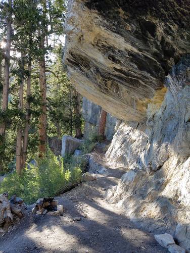
This difficult out and back hike climbs nearly 2,500-feet towards a beautiful lookout point and follows a well maintained, but steep graded trail. When I did this hike in late June of 2019, all the water was dried up so I never found any waterfalls or springs, but the lookout alone was worth the hike. The total mileage for this hike is 6.7-miles, with fairly smooth terrain leading up dirt trails and switchbacks. While this trail is still fairly exposed, there are enough places to find shade to take a break while still under the tree line. However sunscreen and plenty of water are a must-have when hiking this trail.
While quite steep, kids and dogs would both be fine on this trail.
Water source: There's a seasonal spring located around mile 2.5 while hiking up this trail, but you must use a water filter before drinking.
What to bring: Plenty of water - at least 2 liters per person, if not 3 to be safe. Sun screen - reapply as directed and do not forget to reapply.
Facilities: There are restrooms at the trailhead.
Parking: The parking area is of moderate size, which is fine for weekdays, but often overflows on weekends. Show up early to ensure you get a parking spot.
Warnings: This trail begins at about 8,000-feet, so people who are not used to high altitudes may get altitude sickness. Be aware of the warning signs: head aches, dizziness, short breaths, etc. and head back down the trail if you begin to feel sick. It's best if you can spend at least 30-minute acclimating to the altitude before heading up the trail. You can acclimate by walking around the parking lot. This trail also has a lot of sun exposure, so bring a hat and plenty of sun screen.
Pets: Dogs are allowed if leashed and their waste must be carried out.
This trail follows the most popular route to reach Charleston Peak, so plan on heavy foot traffic on weekends. Hikers will find amazing views along with a break from the desert heat due to the elevation that the trail sits at, so this trail is a must see for any hiker near Las Vegas.
This difficult out and back hike climbs nearly 2,500-feet towards a beautiful lookout point and follows a well maintained, but steep graded trail. When I did this hike in late June of 2019, all the water was dried up so I never found any waterfalls or springs, but the lookout alone was worth the hike. The total mileage for this hike is 6.7-miles, with fairly smooth terrain leading up dirt trails and switchbacks. While this trail is still fairly exposed, there are enough places to find shade to take a break while still under the tree line. However sunscreen and plenty of water are a must-have when hiking this trail.
While quite steep, kids and dogs would both be fine on this trail.
Water source: There's a seasonal spring located around mile 2.5 while hiking up this trail, but you must use a water filter before drinking.
What to bring: Plenty of water - at least 2 liters per person, if not 3 to be safe. Sun screen - reapply as directed and do not forget to reapply.
Facilities: There are restrooms at the trailhead.
Parking: The parking area is of moderate size, which is fine for weekdays, but often overflows on weekends. Show up early to ensure you get a parking spot.
Warnings: This trail begins at about 8,000-feet, so people who are not used to high altitudes may get altitude sickness. Be aware of the warning signs: head aches, dizziness, short breaths, etc. and head back down the trail if you begin to feel sick. It's best if you can spend at least 30-minute acclimating to the altitude before heading up the trail. You can acclimate by walking around the parking lot. This trail also has a lot of sun exposure, so bring a hat and plenty of sun screen.
Pets: Dogs are allowed if leashed and their waste must be carried out.