Trail names: Toms Creek Trail, Big Egypt Road, Egypt Mills Road
Location: Egypt Mills Road, Delaware Water Gap Recreation Area, Bushkill,PA
Permitted uses: Hiking, Nature Study, Picnicking: groups of thirty or more require a permit. Catch and release fishing in accordance with PA laws.
Prohibited uses: No Swimming, No Fires and No Alcoholic Beverages, No Camping, No bikes, No horses, No digging, collecting or removing of artifacts or plants.
Hours: Open sunrise to sunset
Fees and Parking: There is no fee to park or use the trails. There is plenty of off street parking in the lot.
Pets: Pets must be on a leash at all times.
Accessibility: The bathrooms and picnic area are wheelchair accessible. There might be some sections of the trail where a wheelchair could access. This would be the parts where the trail is flat and the substrate is gravely. However, the trail as we hiked it, is not wheelchair accessible.
Hiker amenities: There are two vault restrooms at the trailhead, picnic tables, trash and recycling bins. There is a Trail map and a Park Map posted at the trailhead.
Length and Trail information: This hike was done as a loop and was approximately 2.73 miles in length. The trail is marked with a blue trail blaze. This trail is considered to be easy, however some sections that were in need of maintenance were more moderate due to the steepness of the trail, the lack of blazing, road washouts and the overgrowth of vegetation. Without a downloaded map, the moderate section up the hill and beyond would not be advised.
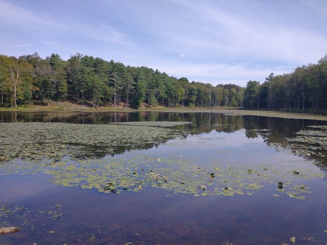
This trail begins alongside Toms Creek which is a state designated trout stream. There are multiple easy access points to the stream from the trail for fishing. During our visit we did not see anyone fishing, likely due to the low water levels, but we did encounter several other visitors along the trail. Apparently, most people hike Toms Creek Trail as a short, out and back hike. The trail appears to terminate not far from where the stream turns and a crude wooden bench can be found alongside the stream. The trail actually continues up a very steep hill, but the trail is poorly marked. We made our way up the hill to continue our hike in hopes of finding Landis Lake. The blue blazes are sporadic and since this is not hiked often, it can be difficult to decipher which way the trail goes, especially when you get nearer to Landis Lake and the vegetation is thicker. When you finally see Landis Lake, it's tempting to go straight toward it. We made that error, as there appeared to be a trail there. We ended up having to turn around, backtracking until we found a stone cairn marking the actual trail and some blazes on a tree. After correcting that error the trail was a little easier to follow and there were better views of Landis Lake from that part of the trail. The trail leads hikers to a large wooden and steel bridge that allows access over the spillway. Use caution while crossing, as the bridge is in need of repair. The bridge allowed access to what appeared to be a class 6 road. This road is an unmaintained section of Big Egypt Road. There are no trail signs or trail markers here, but we kept to our right and hiked toward what looked like a guardrail a short distance down the trail. This turned out to be a sturdy wood and steel guardrail above a washed out section with an exposed culvert. We easily crossed over this washout and continued our hike. The trail is not blazed but is easy to follow because of the many guardrails that are still present. We did encounter one other washout, but we were able to cross it thanks to the water level being low. The trail is as wide as a class 6 road, but there is no maintenance to keep the vegetation down. The trail gently descends back down the hillside through a beautiful mixed forest. It feels really secluded here and we startled a grazing buck as we hiked around a bend in the trail, we watched as he bounded off the trail and disappeared into the thick forest. We also saw bear scat, so be aware that they may be in the area. Also, be on the lookout for snakes and make sure that you do a tick check at the end of this hike.
It was sad to think that no one is using this beautiful section of trail. With a little effort it could be a really nice addition to the hiking found here. We had some really nice views of the ravine and the surrounding forest was really peaceful.
We made our way through the thick vegetation and finally reached the end of the road. We passed through a gate with a sign showing the road was closed to traffic and nestled in the thick overgrowth was a Stop sign that was now stopping no one. We exited here back onto Little Egypt road and turned to the right for a short walk back to the parking area to end our hike.
This was a fun hike with some lovely views of Toms Creek and Landis Lake. The “almost bushwhacking” was fun, and it was a change from what we normally hike. This hike was fun only because we had downloaded a map and knew that we could hike this as a loop. The maintenance along the trail, especially after you climb the steep hill, is seriously lacking and it would be very easy to get lost without a map. Otherwise, it was fun to be out on a rarely hiked section of an unspoiled trail where we felt completely immersed in nature.