The Tibwin Plantation Trail at Francis Marion National Forest in McClellanville, South Carolina is an easy 0.9-mile out-and-back walk that leads to an abandoned plantation house.
This walk begins at the locked entrance gate located on the southeast end of Tibwin Road. Hikers can walk around the gate to follow the old driveway that leads directly to the abandoned plantation house. On the way to the house, visitors will find the road lined with very-old oak trees with hanging Spanish moss. These trees provide most of the scenery along this walk.
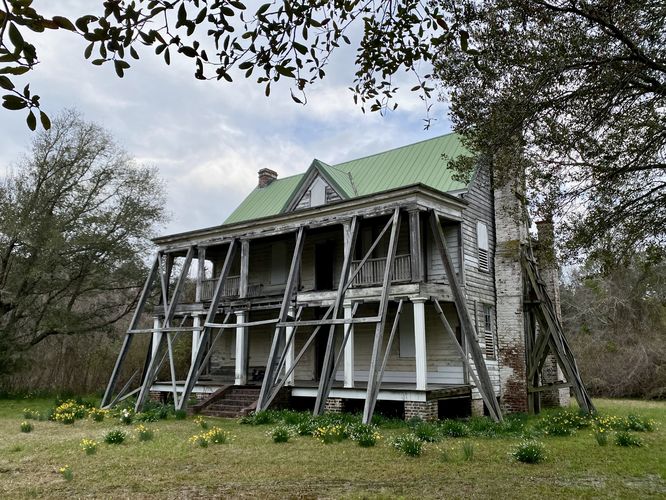
Tibwin Plantation House - Mile 0.9
Around mile 0.9, hikers will reach the abandoned Tibwin Plantation house with its exterior wooden frame holding the structure up. The plantation house was built in 1805 and was constructed closer to the water. After a hurricane in 1822, the house was moved to its current location. The house's door is wide-open and visitors can walk inside if they wish; however, if you enter the house, you go at your own risk. Inside you may find remnants from a bygone era like beautiful old fireplaces, a grand staircase, and large rooms with high ceilings, in addition to other ornate decor. The wealthy slave owners of Tibwin benefited off of the free labor they enforced, which ultimately built this long-abandoned plantation house. During this hike, we stayed outside of the house and only took at peek through the front door.
Fallen Buildings - Mile 0.9
Surrounding the plantation house are a couple of torn-down (or fallen) buildings. Due to the lack of signage, one can only speculate what these buildings were for. One of the buildings appeared to be a smaller house with a chimney. Without proper signage, it's impossible to know what some of these abandoned buildings were used for.
Parking
Hikers will find a small parking turnout located on the west side at the end of Tibwin Road. The parking turnout is large enough to fit no more than 5 vehicles as of March 2024. The parking turnout is located just north of the entrance gate to Tibwin Plantation and has no signage. Most of the signs on the plantation gate make it seem like this is not a public place, but it's in fact part of the national forest and the public is welcome.
History
Tibwin Plantation has been in existence since about 1705 and was a working plantation, powered by slave labor, until the end of the Civil War. In 1848, Tibwin enslaved 105 people until slavery was abolished by the federal government. After the Civil War, the plantation stayed in the hands of the most-recent owner's family members until being sold in the 1930s to George C. Haas who turned it into a hunting club. Sometime after the purchase in the 1930s, Henry Ford purchased a rice mill from Tibwin Plantation. In 1966, the federal government acquired the land and now includes it as part of the Francis Marion National Forest. During that same year (1966), the federal government stabilized the last remaining house on the property and replaced the roof that had been blown off during Hurricane Hugo. For the best historical information on the Tibwin Plantation, you might want to read-up on some of its history provided by this site which has compiled information from several reputable sources. You can also find a list of the known enslaved peoples on Tibwin Plantation here which was provided by the non-profit, Lowcountry Africana.
Personal Thoughts
To me, the idea of visiting an abandoned plantation - once operated by enslaved people - made this walk different from other walks or hikes I've taken throughout the States. The torn-down houses and buildings provided an eerie ghost town-like feeling and I couldn't help but think about the open fields that used to be worked by people who were exploited, unpaid, and had to live through various types of human atrocities against their will. When exploring this place, please remember to visit with respect for those who spent their entire lives working the land without pay, autonomy, or freedom.
This walk begins at the locked entrance gate located on the southeast end of Tibwin Road. Hikers can walk around the gate to follow the old driveway that leads directly to the abandoned plantation house. On the way to the house, visitors will find the road lined with very-old oak trees with hanging Spanish moss. These trees provide most of the scenery along this walk.
Tibwin Plantation House - Mile 0.9
Around mile 0.9, hikers will reach the abandoned Tibwin Plantation house with its exterior wooden frame holding the structure up. The plantation house was built in 1805 and was constructed closer to the water. After a hurricane in 1822, the house was moved to its current location. The house's door is wide-open and visitors can walk inside if they wish; however, if you enter the house, you go at your own risk. Inside you may find remnants from a bygone era like beautiful old fireplaces, a grand staircase, and large rooms with high ceilings, in addition to other ornate decor. The wealthy slave owners of Tibwin benefited off of the free labor they enforced, which ultimately built this long-abandoned plantation house. During this hike, we stayed outside of the house and only took at peek through the front door.
Fallen Buildings - Mile 0.9
Surrounding the plantation house are a couple of torn-down (or fallen) buildings. Due to the lack of signage, one can only speculate what these buildings were for. One of the buildings appeared to be a smaller house with a chimney. Without proper signage, it's impossible to know what some of these abandoned buildings were used for.
Parking
Hikers will find a small parking turnout located on the west side at the end of Tibwin Road. The parking turnout is large enough to fit no more than 5 vehicles as of March 2024. The parking turnout is located just north of the entrance gate to Tibwin Plantation and has no signage. Most of the signs on the plantation gate make it seem like this is not a public place, but it's in fact part of the national forest and the public is welcome.
History
Tibwin Plantation has been in existence since about 1705 and was a working plantation, powered by slave labor, until the end of the Civil War. In 1848, Tibwin enslaved 105 people until slavery was abolished by the federal government. After the Civil War, the plantation stayed in the hands of the most-recent owner's family members until being sold in the 1930s to George C. Haas who turned it into a hunting club. Sometime after the purchase in the 1930s, Henry Ford purchased a rice mill from Tibwin Plantation. In 1966, the federal government acquired the land and now includes it as part of the Francis Marion National Forest. During that same year (1966), the federal government stabilized the last remaining house on the property and replaced the roof that had been blown off during Hurricane Hugo. For the best historical information on the Tibwin Plantation, you might want to read-up on some of its history provided by this site which has compiled information from several reputable sources. You can also find a list of the known enslaved peoples on Tibwin Plantation here which was provided by the non-profit, Lowcountry Africana.
Personal Thoughts
To me, the idea of visiting an abandoned plantation - once operated by enslaved people - made this walk different from other walks or hikes I've taken throughout the States. The torn-down houses and buildings provided an eerie ghost town-like feeling and I couldn't help but think about the open fields that used to be worked by people who were exploited, unpaid, and had to live through various types of human atrocities against their will. When exploring this place, please remember to visit with respect for those who spent their entire lives working the land without pay, autonomy, or freedom.