Tannery Falls Trail at Savoy Mountain State Forest in Savoy, Massachusetts is a moderate 0.5-mile out-and-back hike that features two large waterfalls including Tannery Falls (75 ft), Parker Brook Falls (60 ft), and small cascades within Ross Brook.
Seasonal Road (Open June 1 - December 31 Annually)
This trail's parking lot is only accessible to vehicles from June 1 to December 31 each year. The road is closed from January 1 to May 31 likely due to snow, ice, and lack of maintenance.
Trails
This hike follows one name trail: Tannery Falls Trail (blue blazes).
Hike Description
This hike begins at the main parking lot and trailhead for the Tannery Falls Trail and follows the blue blazed path as it leads through the evergreen-filled woods. This trail is by far one of my personal favorites in Massachusetts to due to the "Pacific Northwest feels" that it provides hikers -- the scenery along Ross Brook is mossy, fern-filled, and shaded by hemlocks and pine trees which makes for unique forest scenery.
Small Gorge Waterfalls - Mile 0.1 to 0.15
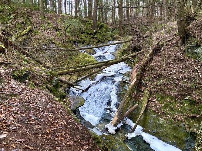
Around mile 0.1, the trail will bend around Ross Brook to a viewing area of some very short, but scenic cascades that flow down the creek. Each cascade around mile 0.1 is about 4-feet tall. Around mile 0.15, just down the trail, is a waterfall that cascades into the small gorge located just off-trail -- hikers can enjoy this ~7-foot tall waterfall as it spills down the brook's bedrock.
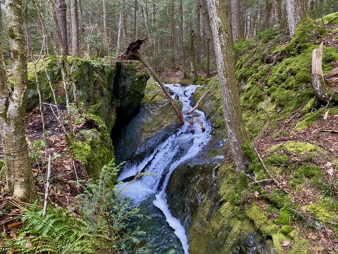
Top of Tannery Falls - Mile 0.17
At mile 0.17, hikers will reach the top of the 75-foot tall Tannery Falls. Aside from the rushing water and waterfall sounds, there's not a whole lot to see from the top of the waterfall. To get the best view, you'll have to hike down the staircase. Note that during colder months (i.e. December), there will likely be ice built-up along the trail -- bring ice spikes to help with the ice.
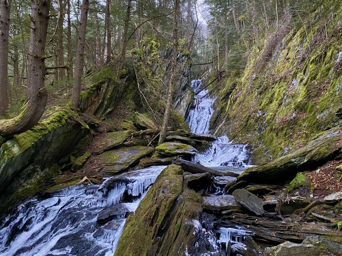
Parker Brook Falls, approx. 60-feet tall - Mile 0.23
After traversing down the switchbacks of the staircase from the top of Tannery Falls, hikers will reach a viewing area from the base of Parker Brook Falls. Parker Brook Falls cascades down the bedrock ravine of Parker Brook in a multitude of tiers -- making up this 60-foot tall waterfall. Parker Brook Falls is an interesting cascade as most of the bedrock is slated, so the waterfall appears slanted as well. The hike is not yet over though, still one more waterfall to see!
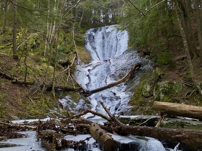
Tannery Falls - Mile 0.25 to 0.27
At mile 0.25, hikers will pass by the side of the 75-foot tall Tannery Falls -- from the trail you can get a neat side view of the waterfall. The best view is from the base of Tannery Falls, located at the end of the trail, around mile 0.27. From the end of the trail, hikers will get an unobstructed view of the 75-foot tall Tannery Falls as it cascades down the bedrock. During the Winter (December), the waterfall is often found with chunks of ice lining the side of the slowing water. Tannery Falls is by far one of the most beautiful waterfalls that I've personally seen in Massachusetts.
Hiking out obviously follows the same path that you hiked-in on. The hike up the stairs is straight forward unless covered in ice. Make sure to enjoy the waterfalls on your hike out, you never know when you might be back here if ever.
Parking
Hikers will find a large parking lot at the coordinates provided, located on the north side of Tannery Road in Savoy, MA. The parking lot has signage along the road as you approach and the lot is large enough to fit a couple dozen vehicles, max. Remember that this road is closed from January 1 to May 31 annually due to snow, ice, and lack of maintenance.
Pet
Dogs are allowed only if leashed and must be cleaned up after.
Warning
Icy stairs: During December (and maybe late November), ice begins to build-up along the staircase that lead to the base of Tannery Falls (and viewing area for Parker Brook Falls). It's smart to bring ice spikes to attach to your shoes or boots just in case you're hiking here during cold months.
Seasonal Road (Open June 1 - December 31 Annually)
This trail's parking lot is only accessible to vehicles from June 1 to December 31 each year. The road is closed from January 1 to May 31 likely due to snow, ice, and lack of maintenance.
Trails
This hike follows one name trail: Tannery Falls Trail (blue blazes).
Hike Description
This hike begins at the main parking lot and trailhead for the Tannery Falls Trail and follows the blue blazed path as it leads through the evergreen-filled woods. This trail is by far one of my personal favorites in Massachusetts to due to the "Pacific Northwest feels" that it provides hikers -- the scenery along Ross Brook is mossy, fern-filled, and shaded by hemlocks and pine trees which makes for unique forest scenery.
Small Gorge Waterfalls - Mile 0.1 to 0.15
Around mile 0.1, the trail will bend around Ross Brook to a viewing area of some very short, but scenic cascades that flow down the creek. Each cascade around mile 0.1 is about 4-feet tall. Around mile 0.15, just down the trail, is a waterfall that cascades into the small gorge located just off-trail -- hikers can enjoy this ~7-foot tall waterfall as it spills down the brook's bedrock.
Top of Tannery Falls - Mile 0.17
At mile 0.17, hikers will reach the top of the 75-foot tall Tannery Falls. Aside from the rushing water and waterfall sounds, there's not a whole lot to see from the top of the waterfall. To get the best view, you'll have to hike down the staircase. Note that during colder months (i.e. December), there will likely be ice built-up along the trail -- bring ice spikes to help with the ice.
Parker Brook Falls, approx. 60-feet tall - Mile 0.23
After traversing down the switchbacks of the staircase from the top of Tannery Falls, hikers will reach a viewing area from the base of Parker Brook Falls. Parker Brook Falls cascades down the bedrock ravine of Parker Brook in a multitude of tiers -- making up this 60-foot tall waterfall. Parker Brook Falls is an interesting cascade as most of the bedrock is slated, so the waterfall appears slanted as well. The hike is not yet over though, still one more waterfall to see!
Tannery Falls - Mile 0.25 to 0.27
At mile 0.25, hikers will pass by the side of the 75-foot tall Tannery Falls -- from the trail you can get a neat side view of the waterfall. The best view is from the base of Tannery Falls, located at the end of the trail, around mile 0.27. From the end of the trail, hikers will get an unobstructed view of the 75-foot tall Tannery Falls as it cascades down the bedrock. During the Winter (December), the waterfall is often found with chunks of ice lining the side of the slowing water. Tannery Falls is by far one of the most beautiful waterfalls that I've personally seen in Massachusetts.
Hiking out obviously follows the same path that you hiked-in on. The hike up the stairs is straight forward unless covered in ice. Make sure to enjoy the waterfalls on your hike out, you never know when you might be back here if ever.
Parking
Hikers will find a large parking lot at the coordinates provided, located on the north side of Tannery Road in Savoy, MA. The parking lot has signage along the road as you approach and the lot is large enough to fit a couple dozen vehicles, max. Remember that this road is closed from January 1 to May 31 annually due to snow, ice, and lack of maintenance.
Pet
Dogs are allowed only if leashed and must be cleaned up after.
Warning
Icy stairs: During December (and maybe late November), ice begins to build-up along the staircase that lead to the base of Tannery Falls (and viewing area for Parker Brook Falls). It's smart to bring ice spikes to attach to your shoes or boots just in case you're hiking here during cold months.