The Takhlakh Lake and Takh Takh Meadows hike at Gifford Pinchot National Forest is a moderate 2.9-mile loop trail that features stunning views of Mt Rainier, the Goat Rocks, and Mt Adams.
Overview:
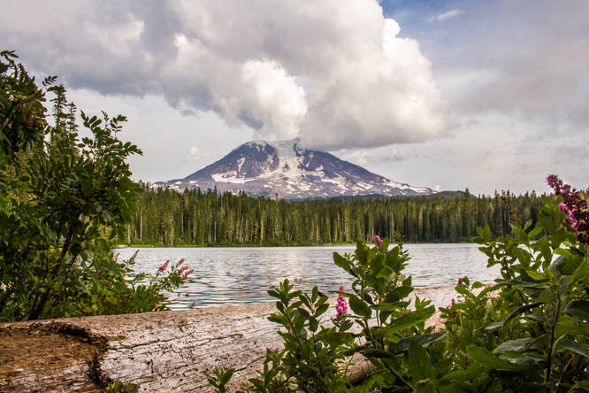
This is a figure eight loop around Takhlakh Lake and Takh Takh Meadow, ascending up a lava flow for fantastic vistas of Mt Rainier, the Goat Rocks, and Mt Adams.
(Note: the GPS track here does not include the described loop around Takhlakh Lake, or the "user trail" skirting the edge of the lava bed, but instead shows the actual trail route over the lava bed.)
The hike typically starts from the day use area at Takhlakh Lake Campground, but it can also be started from Takh Takh Meadow along FR-2329 or any other road crossing on the Takh Takh Meadow Trail.
The Takhlakh Loop Trail #134 is Universal Access (the first part, going counter-clockwise from the day use area to the Takh Takh Meadows Trail junction is more flat and smooth/barrier free, but the latter half of the loop around the lake on the loop trail is more difficult access, with a narrower tread and steeper grades.
Trail Description:
Hike any direction around the lake on the Takhlakh Loop Trail #134. Going right (counterclockwise) takes you immediately across a small wooden bridge (outflow of Takhlakh Lake) with picture-perfect views of Mt Adams across the lake, then past car campsites as you hike past the main campground area. The trail then wanders through a lush, boggy forest before reaching a junction with a trail to the left and a sign for "Fish Pad." There is a good view of the other side of the lake down this short spur trail. Past the junction for Fish Pad, reach the junction with the Takh Takh Meadow Trail.
To make the figure eight loop, turn right at the junction, leaving the lake behind. Get to a second junction, the return trail. Turn left or right; either way, it makes a loop right back to this spot. Turning left here (clockwise) is recommended to get the best views.
After turning left, the trail soon crosses FR-2329 and ascends through open montane forests with a largely huckleberry understory (in season). After a ways, the trail begins to contour just above the edge of the lava bed to your left. Soon reach the foot of the lava bed in a more open area, and two unnamed junctions present before you. The more obvious user trail to the right follows the edge of the lava bed all the way to Takh Takh Meadow, rather than ascending up and over it. (You might even miss this unmarked junction, as many people seem to do quite often!) You'll know you missed this junction if you have to climb over/around a couple of large boulders.
Turn left at the unmarked junction to follow the Takh Takh Meadow Trail. Immediately, it starts to ascend up the rubbly jumble of andesitic grey boulders that is the Takh Takh Lava Flow. The trail has been blasted into the rock here. Notice the wavy patterns seen in the many gullies below and around.
As the trail reaches the top, the views open up to the north towards Mount Rainier and the jagged eroded volcanic remnant that is the Goat Rocks, a volcano once likely as tall and mighty as nearby Mount Adams. Limited views of Mount Adams can also be had from here through the trees.
The trail gradually wanders over the top of the lava flow, ascending very gently, before it makes a sharp right turn and descending quickly back down to the surrounding valley floor. Here, the trail meets up with the unofficial user trail mentioned earlier. You can loop back down the user trail to the right to make a very short lollipop loop, but doing so misses the splendid Takh Takh Meadow.
Turn left to stay on the Takh Takh Meadow Trail, and very soon reach the edge of Takh Takh Meadow. Here, various user trails branch out.
The Takh Takh Meadow Trail makes a right turn here and heads toward FR-2329, then crosses it.
Turn left if you want to explore the edge of the meadow further. A well established user trail follows the eastern edge of the meadow, sandwiched between the meadow and the lava flow. Turn around whenever you want, then rejoin and continue along the Takh Takh Meadow Trail. Just before it crosses the road is a stunning view of Mount Adams rising above the meadow.
After crossing FR-2329, the trail gently descends back down to merge up with the other end of itself. Turn left to continue heading down to Takhlakh Lake, retracing your steps along this very short segment. Once back at the Takhlakh Loop Trail, turn right to finish the loop around the lake. The east side of the lake is steeper and less graded, but has great views of Mount Adams across the lake from various points as you near the day use area.
Directions:
From Trout Lake, take FR 23 for approximately 24 miles to FR 2329. Then drive 1.5 miles to Takhlakh Lake Campground. The start of the hike is just inside the campground at the day use and boat launch area. You can also start the hike from the campground itself, or along any of the two points that the Takh Takh Meadow Trail crosses FR-2329 (0.6 miles and 1.1 miles past Takhlakh Lake Campground).