The Sugar Run Trail to Jonathan Run Falls is a moderate 4 mile out-and-back hike in the northern section of Ohiopyle out to two waterfalls: Jonathan Run Falls and Fetcher Run Falls. Please note that a bridge between the Jonathan Run trailhead and the intersection with the Sugar Run Trail is out, hence the need to hike into Jonathan Run Falls via the Sugar Run Trail instead.
The hike starts out at the large parking lot along Sugar Run Rd and follows the road in the woods for about a half mile before the trail heads downhill to the first creek crossing - Sugar Run. You'll cross two small wooden bridges, first crossing Sugar Run, then you'll cross a tributary creek that feeds Sugar Run.
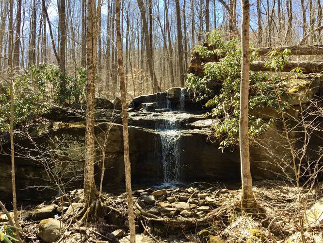
Hike for another 1 mile or so before you reach another creek crossing - this is Fetcher Run. When you reach Fetcher Run, take a small detour towards Jonathan Run and hike down into the gorge a bit where you'll find Fetcher Run Falls - a roughly 8-foot waterfall that cascades down these massive rocks and spills into Jonathan Run below. In this GPS track, Fetcher Run Falls can be found in the elevation data on the hike out.
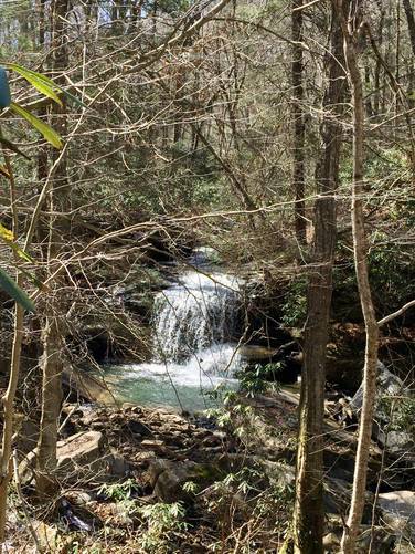
Continuing on from Fetcher Run Falls, you'll hike for another 0.2 miles before reaching the Jonathan Run Trail. Take a left at the intersection and cross the bridge over Jonathan Run. Follow the trail downhill for another 0.4 miles before you start to hear a loud rushing of water - this is Jonathan Run Falls.
Jonathan Run Falls is about 20-feet tall and cascades down two tiers within Jonathan Run. The first tier is about 5-feet, while the 2nd tier is about 15-feet. Please note that getting down and closer to Jonathan Falls is very dangerous. The trail that heads downhill is extremely steep with plenty of mud, leaves, and roots to slip and trip on. Since the grade is so steep, you need to essentially crawl downhill to get to the falls. There's a make-shift rope that someone tied to some trees here that you can use to get down easier; however, it's still extremely sketchy, hence why the pictures I took were not directly next to Jonathan Falls. You can also enjoy a nice view of the falls from the trail if you visit when there are no leaves on the trees.
Dogs and biking are both allowed on this trail. Hunting is also permitted on this trail, so it's smart to wear blaze-orange.
As of March 2019, the hike to Jonathan Run Falls follows red blazes from the parking lot all the way to the falls (and likely beyond).
The hike starts out at the large parking lot along Sugar Run Rd and follows the road in the woods for about a half mile before the trail heads downhill to the first creek crossing - Sugar Run. You'll cross two small wooden bridges, first crossing Sugar Run, then you'll cross a tributary creek that feeds Sugar Run.
Hike for another 1 mile or so before you reach another creek crossing - this is Fetcher Run. When you reach Fetcher Run, take a small detour towards Jonathan Run and hike down into the gorge a bit where you'll find Fetcher Run Falls - a roughly 8-foot waterfall that cascades down these massive rocks and spills into Jonathan Run below. In this GPS track, Fetcher Run Falls can be found in the elevation data on the hike out.
Continuing on from Fetcher Run Falls, you'll hike for another 0.2 miles before reaching the Jonathan Run Trail. Take a left at the intersection and cross the bridge over Jonathan Run. Follow the trail downhill for another 0.4 miles before you start to hear a loud rushing of water - this is Jonathan Run Falls.
Jonathan Run Falls is about 20-feet tall and cascades down two tiers within Jonathan Run. The first tier is about 5-feet, while the 2nd tier is about 15-feet. Please note that getting down and closer to Jonathan Falls is very dangerous. The trail that heads downhill is extremely steep with plenty of mud, leaves, and roots to slip and trip on. Since the grade is so steep, you need to essentially crawl downhill to get to the falls. There's a make-shift rope that someone tied to some trees here that you can use to get down easier; however, it's still extremely sketchy, hence why the pictures I took were not directly next to Jonathan Falls. You can also enjoy a nice view of the falls from the trail if you visit when there are no leaves on the trees.
Dogs and biking are both allowed on this trail. Hunting is also permitted on this trail, so it's smart to wear blaze-orange.
As of March 2019, the hike to Jonathan Run Falls follows red blazes from the parking lot all the way to the falls (and likely beyond).