The Spook Hollow & Ole Bull Vista Loop at Susquehannock State Forest near Cross Fork, Pennsylvania is a moderate 5-mile hike that features a Halloween-themed pine hollow named Spook Hollow and also features a beautiful vista point facing mountains that surround Ole Bull State Park, making this the perfect hike in Potter County for October.
Trails
This hike follows several named trails and roads in order: Susquehannock Trail System aka STS (orange blazes), Snowmobile Trail (red blazes), Spring Brook Rd, Joerg Rd, Smartwood Trail (red blazes), Twelve Mile Rd.
Hike Description
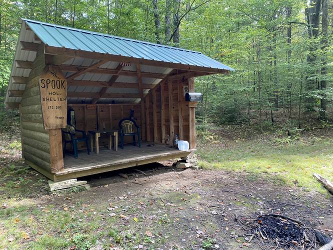
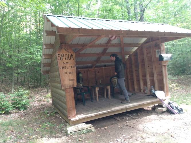
This hike begins along Twelve Mile Rd - just south of where the STS heads east from the road. Hikers will note the number "23" on the STS sign before hiking downhill from the road - this is mile marker 23 for the STS. The STS follows orange blazes downhill for about 0.2-miles before reaching the Spook Hollow Shelter - built in 2017. The Spook Hollow Shelter along the STS is a great spot to setup camp and escape the rain, if needed, while backpacking. Hikers and backpackers will also enjoy the Halloween-themed knickknacks and props left at the shelter.
Spook Hollow Pine Forest - mile 0.4
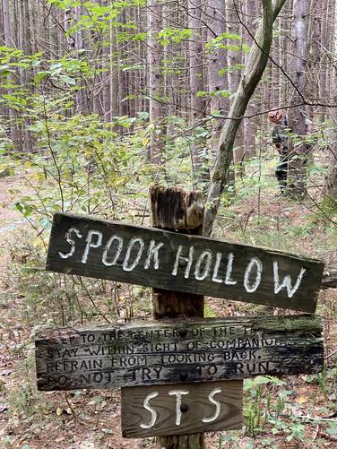
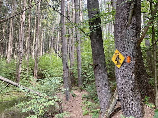
Around mile 0.4, hikers will reach the entrance to Spook Hollow, with a sign that's labeled "Spook Hollow" and another sign that's labeled "Keep to the center of the trail. Stay within sight of companions. Refrain from looking back. Do not try to run." This section of the hike is the first main attraction as the STS cuts through a spooky evergreen forest with a mix of red pine, Norway spruce, and possibly some white spruce. On the other end of Spook Hollow is a "Bigfoot Crossing" sign. While no Bigfoot were seen on this trip, it's best to keep an eye out for spooky forest creatures potentially lurking in this evergreen hollow...
Snowmobile Trail to Spring Brook Rd
Once the hiker exits Spook Hollow, they'll find themselves in a clear-cut pipeline area. This is where the Snowmobile Trail heads southwest, following red blazes. The hike, headed toward Ole Bull Vista, is fairly easy as the Snowmobile Trail undulates its way along the pipeline while making two road crossings along the way.
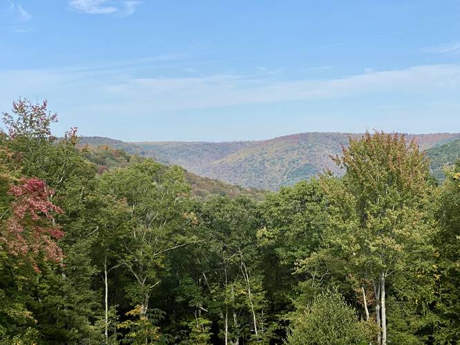
Ole Bull Vista - mile 2.26
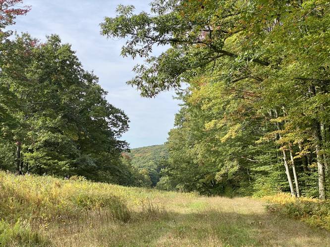
Around mile 2.14, this track cuts through the woods off-trail between the Snowmobile Trail and Spring Brook Rd to reach the Ole Bull Vista. The Ole Bull Vista is located around mile 2.26 - and includes a bench for hikers to sit and take a break. The view faces westward into mountains that surround Ole Bull State Park. During early to mid-October the foliage change can make the hillsides pop with color.
Hiking to the Smartwood Trail
After visiting the Ole Bull Vista, hikers will continue walking down Spring Brook Rd, keeping right - before reaching Joerg Rd. At Joerg Rd, take a right-hand turn to follow the forest road downhill for about 0.8 miles before reaching the Smartwood Trail.
Smartwood Trail to Twelve Mile Rd
The Smartwood Trail starts off along a gradual-grade as it makes its way slowly up the mountain hollow on what looks like an old log slide. Not long after the hike begins, the trail will quickly turn into a moderate grade - making this hike a bit more difficult than expected. The moderate grade lasts all the way until the hiker is about one-tenth of a mile from Twelve Mile Rd. The entire length of the Smartwood Trail is about 0.7-miles one-way and the elevation gain is over 440-feet.
Twelve Mile Rd to Parking
Once back on Twelve Mile Rd, the hiker will walk north for about 0.8-miles to reach the parking area and complete the loop hike for about 5-miles total.
Parking
Hikers will find a large parking turnout near a yellow gate by the coordinates provided. The turnout is large enough for about 5 vehicles or more without blocking the gate. Do not block the yellow service gate.
Pets
These trails are dog-friendly and their waste should be carried out by the hiker.
Biking
Biking is allowed along all of these trails and roads except for the STS. Please do not bike ride along the STS or through Spook Hollow. Additionally, horses are not allowed along the STS.
Camping and Backpacking
Camping is allowed along these trails where state forest rules permit backcountry / dispersed / primitive camping. The Spook Hollow Shelter is by far the best place to camp along this hike; however, there were not any other pre-defined campsites along this hike. The only other places a campsite may be temporarily setup is along the lower grade of the Smartwood Trail.
Trails
This hike follows several named trails and roads in order: Susquehannock Trail System aka STS (orange blazes), Snowmobile Trail (red blazes), Spring Brook Rd, Joerg Rd, Smartwood Trail (red blazes), Twelve Mile Rd.
Hike Description
This hike begins along Twelve Mile Rd - just south of where the STS heads east from the road. Hikers will note the number "23" on the STS sign before hiking downhill from the road - this is mile marker 23 for the STS. The STS follows orange blazes downhill for about 0.2-miles before reaching the Spook Hollow Shelter - built in 2017. The Spook Hollow Shelter along the STS is a great spot to setup camp and escape the rain, if needed, while backpacking. Hikers and backpackers will also enjoy the Halloween-themed knickknacks and props left at the shelter.
Spook Hollow Pine Forest - mile 0.4
Around mile 0.4, hikers will reach the entrance to Spook Hollow, with a sign that's labeled "Spook Hollow" and another sign that's labeled "Keep to the center of the trail. Stay within sight of companions. Refrain from looking back. Do not try to run." This section of the hike is the first main attraction as the STS cuts through a spooky evergreen forest with a mix of red pine, Norway spruce, and possibly some white spruce. On the other end of Spook Hollow is a "Bigfoot Crossing" sign. While no Bigfoot were seen on this trip, it's best to keep an eye out for spooky forest creatures potentially lurking in this evergreen hollow...
Snowmobile Trail to Spring Brook Rd
Once the hiker exits Spook Hollow, they'll find themselves in a clear-cut pipeline area. This is where the Snowmobile Trail heads southwest, following red blazes. The hike, headed toward Ole Bull Vista, is fairly easy as the Snowmobile Trail undulates its way along the pipeline while making two road crossings along the way.
Ole Bull Vista - mile 2.26
Around mile 2.14, this track cuts through the woods off-trail between the Snowmobile Trail and Spring Brook Rd to reach the Ole Bull Vista. The Ole Bull Vista is located around mile 2.26 - and includes a bench for hikers to sit and take a break. The view faces westward into mountains that surround Ole Bull State Park. During early to mid-October the foliage change can make the hillsides pop with color.
Hiking to the Smartwood Trail
After visiting the Ole Bull Vista, hikers will continue walking down Spring Brook Rd, keeping right - before reaching Joerg Rd. At Joerg Rd, take a right-hand turn to follow the forest road downhill for about 0.8 miles before reaching the Smartwood Trail.
Smartwood Trail to Twelve Mile Rd
The Smartwood Trail starts off along a gradual-grade as it makes its way slowly up the mountain hollow on what looks like an old log slide. Not long after the hike begins, the trail will quickly turn into a moderate grade - making this hike a bit more difficult than expected. The moderate grade lasts all the way until the hiker is about one-tenth of a mile from Twelve Mile Rd. The entire length of the Smartwood Trail is about 0.7-miles one-way and the elevation gain is over 440-feet.
Twelve Mile Rd to Parking
Once back on Twelve Mile Rd, the hiker will walk north for about 0.8-miles to reach the parking area and complete the loop hike for about 5-miles total.
Parking
Hikers will find a large parking turnout near a yellow gate by the coordinates provided. The turnout is large enough for about 5 vehicles or more without blocking the gate. Do not block the yellow service gate.
Pets
These trails are dog-friendly and their waste should be carried out by the hiker.
Biking
Biking is allowed along all of these trails and roads except for the STS. Please do not bike ride along the STS or through Spook Hollow. Additionally, horses are not allowed along the STS.
Camping and Backpacking
Camping is allowed along these trails where state forest rules permit backcountry / dispersed / primitive camping. The Spook Hollow Shelter is by far the best place to camp along this hike; however, there were not any other pre-defined campsites along this hike. The only other places a campsite may be temporarily setup is along the lower grade of the Smartwood Trail.