The Spatterdock Pond Loop at Beaver Brook Assoaciation - Hollis in Hollis, New Hampshire is an easy 4-mile loop hike that leads to views of Spatterdock Pond and leads to the foundation of the Shoen Farm House.
Trail names: Jeff Smith Trail, Shoen Road, O’Neil Road, French Meadow Cutoff, Eastman Meadow Trail, Beaver Brook Trail, Brook Trail, Elkins Road
Location: Beaver Brook Association Conservation Lands, Route 130, 248 Proctor Hill Road, Hollis NH
Permitted uses: Hiking, Biking on designated trails, Running, Fishing, Nature Study, Cross Country Skiing, Snow Shoeing, Horseback riding on some trails, Letterbox cache, Geocaching
Prohibited uses: No Hunting, No possession of firearms, No motorized vehicles, No trapping, No littering, No alcohol, No fires, No use after dark, No cutting of plants, No collection of wildlife
Hours: Trails are closed after dark
Fees and Parking: There is no fee to park or use the trails. Parking is limited at the trailhead just off side Route 130.
Pets: Please keep your dog(s) leashed to protect wildlife. Please leave no trace and do not leave bagged dog waste along the trail.
Accessibility: This hike is not wheelchair accessible.
There is an information kiosk at the trailhead with a posted map, maps to take with you and a QR code of maps. There are no trash bins, please carry out what you carry in. There are no restrooms.
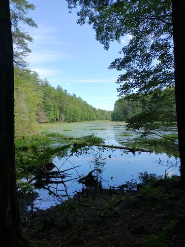
Length and Trail information: This hike was done as a loop, is easy, and almost 4 miles long. There are so many trail options here hikers can easily visit multiple times without doing the same hike each visit. The trails are very well maintained with excellent blazes and signage at each junction. On this hike we hiked trails that had either Blue or Yellow blazes. Occasionally maps are also posted below painted wooden trail signs, helping hikers navigate the multiple trails offered on these protected lands. For the majority of the hike, the substrate was wide and flat with no hazards to watch out for. The trails around the Spatterdock Pond are narrower and there are tree roots to navigate. We found large areas where Mountain Laurel was growing, so this would be a very pretty hike in the Springtime. On this visit, the pond was full of blooming water lilies with Pickerel Weed, Cardinal Flower, Swamp Milkweed, and Goldenrod all in bloom in swampy areas. Hikers will get an up close look at some of these native plants thanks to the excellent access provided by several well maintained wooden bridges and boardwalks that cross over the wet areas. Crossing over these areas allows hikers to see some of the native vegetation in bloom. One bridge that should not be missed is the Bouchard Bridge. This bridge brings hikers over and through a gorgeous part of the pond. There are two benches installed for visitors at the east and west sides of Spatterdock Pond. Hikers can take a break here and watch for bird activity in the many bird houses installed out in the pond. There is also a very nice bird blind at the southern end of the Pond.
There is very little elevation on the trails with the exception of Elkins Road, which has a steady incline on the entire trail. Elkins road is not too difficult or steep, but there was some wash out from recent rains, so the substrate was a little rough and rocky, but nothing too severe.
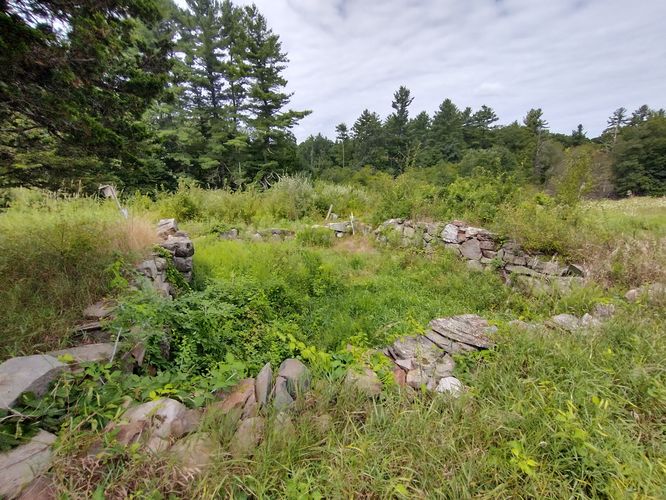
From Elkins Road we turned on to Shoen Road and stopped to investigate the Shoen Farm Wildlife Management area. There is an information kiosk here and an information placard about the site's history. There is an old foundation to see as well as what appears to be a granite monument to Jeffrey Poole Smith who was Co-founder of the Beaver Brook Association and the person for whom the Jeff Smith Trail is named. Jeff Smith bought the property in 1944 and used this land to graze young cattle. In the mid 1970’s he donated the land to the Beaver Brook Association.
This was a great hike and we hope to go back to enjoy the many trail options available thanks to the excellent maintenance done to keep the trails safe and accessible.