The Sol Duc Falls Trail at Olympic National Park near Port Angeles, Washington is a moderate 1.7-mile out-and-back hike that leads to one of Olympic's most-picturesque waterfalls, the ~50-foot tall Sol Duc Falls.
Steep terrain: The terrain that surrounds Sol Duc Falls is very steep and can be deadly. Case and point: a couple of days before our visit in June 2025, a young man was seen walking on the wet slippery rocks located directly above the waterfall. He slipped and fell down into the canyon, and ultimately lost his life. For your own safety, it's best to stay behind the fences, away from the cliff's edge, and off of the slippery rocks.
Hike to Sol Duc Falls
Starting at the main trailhead, hikers will follow a series of steps that lead downhill as the trail makes its way eastward through the lush moss-covered forest. Along the way to Sol Duc Falls, you'll find large ferns, moss-covered trees, hanging mosses, and vibrant vegetation that makes this section of Olympic National Park well-worth visiting.Hillside Cascade - Mile 0.38
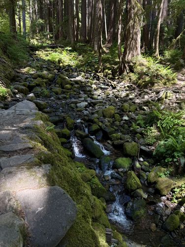
Not far from the trailhead sits a small footbridge that crosses a hillside creek. This hillside creek is littered with loose rocks where water flows down from a slightly-higher elevation, creating a scenic hillside waterfall. While this waterfall is nothing to compare to Sol Duc Falls, it's a really nice spot to take a little break or let other groups of hikers pass you if you're walking a little slower.Backpacking Shelter - Mile 0.8
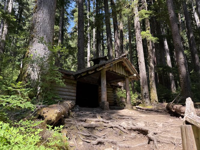
For those who have a backpacking permit, there's a large shelter around mile 0.8 that can be used and is located just a stone's throw from Sol Duc Falls. During the late evening or early morning, this shelter would make for a great way to enjoy the waterfall with seclusion but during peak hours, your seclusion would be totally erased.Sol Duc Falls (50-feet tall) - Mile 0.85
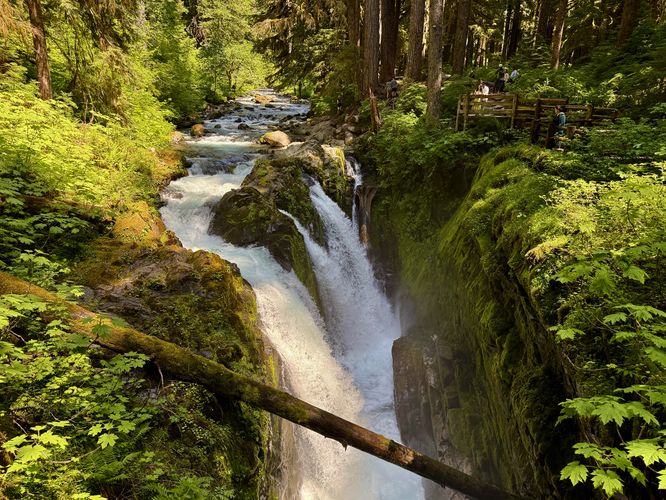
The trail will continue to descent from the backpacking shelter down to a scenic footbridge that crosses the Sol Duc River. Here, you'll cross the bridge to find Sol Duc Falls plummeting over its 50-foot cliff. The waterfall is split by large boulders or bedrock into three streams that swoop down into the canyon below. Sol Duc Falls is extremely powerful so for your own safety, keep back from the cliff's edge. On the opposite side of the waterfall view is a stunning vista of the Sol Duc River as it flows westward where visitors will find a vibrant turquoise pool of water in the canyon far below. This route leads to the very top of Sol Duc Falls located near mile 0.87 in the track provided where visitors will find a head-on view of the waterfall where it splits into three separate cascades. The view here isn't as great as the view from the bridge, but it's a neat perspective nonetheless.Hiking Out - Mile 0.85 to 1.7
The hike out from Sol Duc Falls is straight forward, especially if you plan to follow this out-and-back hike instead of venturing into the Sol Duc area any further. The way back is mostly all uphill, however, with plenty of flat elevation grade. The last push to the parking lot is met with the staircase you hiked down on when heading toward the waterfall. The hike wraps up at the parking lot around mile 1.7.Camping & Backpacking Permits
Note that backpacking is allowed in the Sol Duc area and there's a camping shelter located on-trail around mile 0.8 from the trailhead. If you plan to camp, you must have a wilderness permit. You can learn more about how to backpack the Sol Duc area on the park's official website.Views / Lookout Points
Note that this hike does not have many "proper" views or lookout points outside of the footbridge that spans the Sol Duc River where you'll find beautiful views of the water and canyon.Warning
Cougars: This area is home to the cougar / mountain lion. These animals prefer secluded canyons with thick brush to hunt their prey (which is primarily smaller game). Hike with a friend or a group, make noise as you move through the forest, and be aware of your surroundings. Cougar attacks on humans are very rare.Steep terrain: The terrain that surrounds Sol Duc Falls is very steep and can be deadly. Case and point: a couple of days before our visit in June 2025, a young man was seen walking on the wet slippery rocks located directly above the waterfall. He slipped and fell down into the canyon, and ultimately lost his life. For your own safety, it's best to stay behind the fences, away from the cliff's edge, and off of the slippery rocks.