Loading...

WINTER SALE! 50% OFF Supporter Accounts — now through January 31st. Learn More.

Snaggy Mountain Trail - Swallow Falls Rd to Cranesville Rd

This small portion of the Snaggy Mountain Trail at Garrett State Forest in Oakland, Maryland is an easy 0.6 mile out-and-back hike that leads from Swallow Falls Rd and over to Cranesville Rd and back.

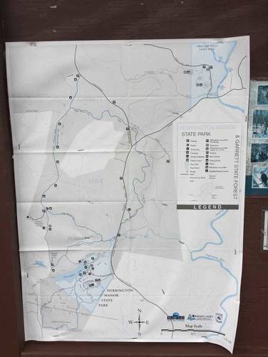
Initially we mapped this hike because we couldn't find any trail maps in the area near where we parked on Swallow Falls Rd; however, we did find a trail map for Garrett State Forest at the other parking lot along Cranesville Rd, where this GPS data meets that road.

There's not much to see on this portion of the Snaggy Mountain Trail; however, note that there's a trail that runs parallel this one, which appears to head to Swallow Falls State Park. There's another parking lot, for this parallel trail, just east on Swallow Falls Rd from where this trail starts.

Dogs and biking are both allowed here. Primitive camping and backpacking are both allowed here as well - please check out the park's site for more details.

Blaze color: This portion of the Snaggy Mountain Trail had blueish-green blaze colors, hence the green blaze setting.
Explore 31 trails near Oakland, MD

Know Before You Go

  • Short, easy 0.6-mile section of Snaggy Mountain Trail in Garrett State Forest, suitable for a quick out-and-back hike.
  • Trail connects Swallow Falls Rd to Cranesville Rd, with a parallel trail offering potential access to Swallow Falls State Park.
  • Dogs and biking are permitted, and primitive camping/backpacking is allowed with park regulations.
Interactive topographic map for Snaggy Mountain Trail - Swallow Falls Rd to Cranesville Rd located in Oakland, MD. Click the "View Map" button to load GPS coordinates and trail markers.
Get directions
Distance
0.6 mi
Difficulty
Easy
Type
Out-and-Back
Est. Time
18 min
Elev. Gain
74'
Rating
0.0
Added
April 14, 2018
Updated
April 14, 2018

Weather Forecast

Loading...
Total Change
54'
Ascent
74'
Descent
74'
Loading...

Download the GPX Data for Offline Use

Supporters get exclusive access to download trail routes to the MyHikes app for offline use. Stay prepared on your adventure, even without an internet connection! Become a Supporter today to unlock this feature and hike with confidence.

Download Snaggy Mountain Trail - Swallow Falls Rd to Cranesville Rd GPX Data to the MyHikes Mobile App

Features

Dogs
Camping
Biking

Points of interest

  1. Parking

    39.484689, -79.43902
  2. Main Trailhead

    39.484912, -79.439066

Safety information

For your own safety: plan ahead, let someone know where you'll be, and hike at your own risk.

Markers

Blaze Color

Green

Availability

All seasons

Surface type

Dirt

Trip Reports (Reviews)

Your opinion matters! Be the first to rate this trail.

Ready to help fellow hikers? Add a trip report to share your experience and provide valuable insights for other hikers!

0.6 miles / 1.0 km
March 30, 2018
Hiking
No community routes found. To add your own hike as a Community Route for this Trail guide, leave a Trip Report with an attached GPX file.

Popular categories

Scenic mountain view representing vista trails
Vista trails
Scenic gorge of cascades representing waterfall trails
Waterfall hikes
Rugged mountain terrain representing summit trails
Summit trails
Scenic mountain view representing dog-friendly trails
Dog-friendly
Scenic campsite with a view representing camping trails
Camping trails
Appalachian Trail logo representing A.T. hikes
A.T. hikes

You May Also Like

Colorado's Million Dollar Highway - Plan a day's drive adventure along the iconic Million Dollar Highway in Colorado. Explore the best short trails, roadside stops, waterfalls, vistas, ghost towns, and hot springs within a ~6 hour road trip.
Explore

Colorado's Million Dollar Highway

Plan a day's drive adventure along the iconic Million Dollar Highway in Colorado. Explore the best short trails, roadside stops, waterfalls, vistas, ghost towns, and hot springs within a ~6 hour road trip.

Read
🍪 We use cookies to learn about site usage and to serve map tiles. You may block cookies manually in the browser. By continuing you agree. Learn more