The Sizerville Nature Trail at Elk State Forest in Emporium, Pennsylvania is a difficult 3.5-mile loop trail that features a beautiful vista point.
This trail is difficult no matter which direction you hike the loop in, but this recording heads clockwise around the loop. Hiking this trail in the counter-clockwise direction is even more difficult due to the steeper grade that winds its way between two mountains in the northern section of the loop.
The trail follows yellow blazes up the mountain for the entire hike. There are a couple of spur trails that lead off of the main trail - the most important spur trail being the overlook which is an additional 0.25-miles out-and-back. The second spur trail leads to a tree planting by the CCC which appears to have happened back in the 1930's.
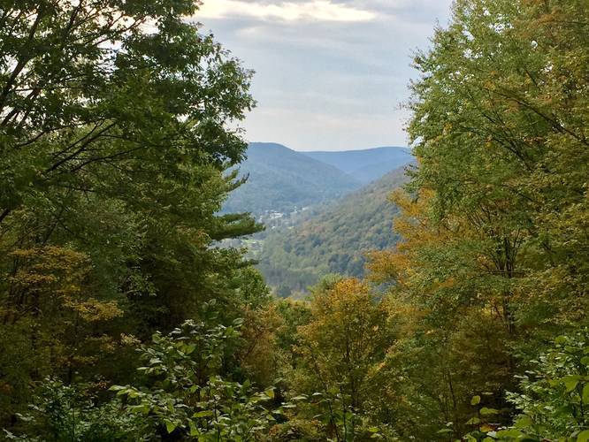
The climb up the mountain lasts approximately 1.2-miles before the trail evens out and follows a level mountain top. Right at mile 1.2, hikers will find the vista point spur trail. Hike down and back along this trail to reach the vista point.
After visiting the vista point, hikers will continue north along the mountain top before the trail begins its descent along a ravine that sits between two mountains. This section of the trail has a half-dozen switchbacks and has a steeper grade than the southern section of the loop. Here, hikers must pay attention to the blazes since they can sometimes disappear fairly easily.
Once you hike down the northern mountain ravine, the trail will level out once again before reaching the parking lot to complete this 3.5-mile loop hike.
History
The mountains in this area were carved out by the receding glaciers. Hikers will find massive boulders in the northern mountain ravine, located right off the trail. These boulders are glacial deposits left over from the last ice age. Additionally, this land was once clear-cut by settlers to meet the lumber needs of their day. This clear-cutting lead to additional wildfires that broke out causing most of the remaining trees to burn. Without trees to hold back the soil, the mountains began to erode, choking nearby streams.
The thriving forest that sits here today are credited to visionary men and women who passed laws to protect Pennsylvania's forests and eventually became the Department of Conservation and Natural Resources (DCNR).
Thanks to their efforts and nature's restorative process, by the 1950's what were once bare hills, again supported trees large enough to harvest. Fortunately, sustainable logging methods resulted in minimal impacts to the forest. The logging roads remain today and make up part of this trail.
Self-guided Tour
Along the trail are numbered posts, which correspond to descriptions in a pamphlet hikers can pick up at the trailhead. Take one per party so that others can pick up a trail guide too.
Parking
Hikers can find parking at the coordinates provided. The lot is large enough to fit about ten vehicles.
Pets
Dogs are allowed if leashed and their waste must be carried out by the hiker.
Camping
Backpacking and camping are allowed on this trail; however, there were no designated camping areas. If you plan to backpack here, remember to leave no trace and follow the state forest's rules for camping. More information can be found on the park's site.
Biking
Mountain biking is allowed on this trail.
This trail is difficult no matter which direction you hike the loop in, but this recording heads clockwise around the loop. Hiking this trail in the counter-clockwise direction is even more difficult due to the steeper grade that winds its way between two mountains in the northern section of the loop.
The trail follows yellow blazes up the mountain for the entire hike. There are a couple of spur trails that lead off of the main trail - the most important spur trail being the overlook which is an additional 0.25-miles out-and-back. The second spur trail leads to a tree planting by the CCC which appears to have happened back in the 1930's.
The climb up the mountain lasts approximately 1.2-miles before the trail evens out and follows a level mountain top. Right at mile 1.2, hikers will find the vista point spur trail. Hike down and back along this trail to reach the vista point.
After visiting the vista point, hikers will continue north along the mountain top before the trail begins its descent along a ravine that sits between two mountains. This section of the trail has a half-dozen switchbacks and has a steeper grade than the southern section of the loop. Here, hikers must pay attention to the blazes since they can sometimes disappear fairly easily.
Once you hike down the northern mountain ravine, the trail will level out once again before reaching the parking lot to complete this 3.5-mile loop hike.
History
The mountains in this area were carved out by the receding glaciers. Hikers will find massive boulders in the northern mountain ravine, located right off the trail. These boulders are glacial deposits left over from the last ice age. Additionally, this land was once clear-cut by settlers to meet the lumber needs of their day. This clear-cutting lead to additional wildfires that broke out causing most of the remaining trees to burn. Without trees to hold back the soil, the mountains began to erode, choking nearby streams.
The thriving forest that sits here today are credited to visionary men and women who passed laws to protect Pennsylvania's forests and eventually became the Department of Conservation and Natural Resources (DCNR).
Thanks to their efforts and nature's restorative process, by the 1950's what were once bare hills, again supported trees large enough to harvest. Fortunately, sustainable logging methods resulted in minimal impacts to the forest. The logging roads remain today and make up part of this trail.
Self-guided Tour
Along the trail are numbered posts, which correspond to descriptions in a pamphlet hikers can pick up at the trailhead. Take one per party so that others can pick up a trail guide too.
Parking
Hikers can find parking at the coordinates provided. The lot is large enough to fit about ten vehicles.
Pets
Dogs are allowed if leashed and their waste must be carried out by the hiker.
Camping
Backpacking and camping are allowed on this trail; however, there were no designated camping areas. If you plan to backpack here, remember to leave no trace and follow the state forest's rules for camping. More information can be found on the park's site.
Biking
Mountain biking is allowed on this trail.