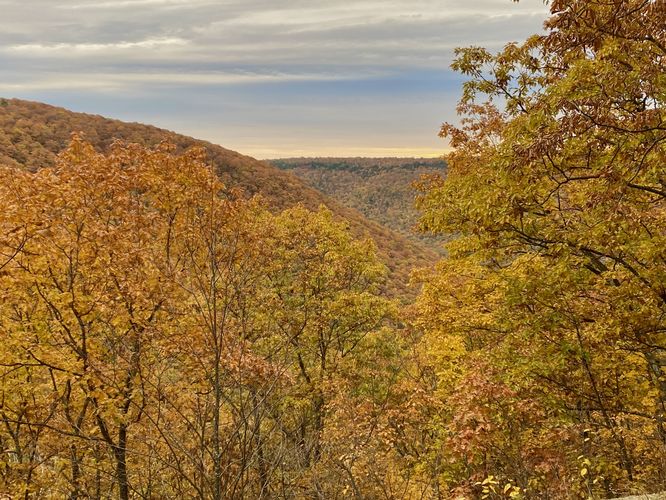
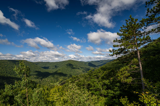
The Sinnemahoning Canyon Vistas hike at Elk State Forest near Wyside, Pennsylvania is a difficult 4.7-mile out-and-back hike that features several stunning off-trail vistas of Sinnemahoning Canyon and Creek.
Bushwhacking
Note that this hike includes bushwhacking; however, most of the forest floor is wide-open with the exception of many teaberry and blueberry bushes. My 22lbs dog had a fine time bushwhacking these small shrubs, but going off-trail is not for everyone. If planning on doing this hike, remember to bring an offline GPS tracker, like the MyHikes apps to find your way!
Hike Description
This hike begins along Montour Road (at the coordinates provided) and follows a gated service road from the parking area. Hikers will follow the service road until they reach the main pipeline - take a left-hand turn here to hike south along the pipeline.
Easy-to-Miss Left-Hand Turn - Mile 0.4
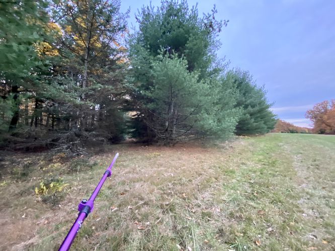
Around mile 0.4, on the pipeline, hikers will notice a small cutout within the pine trees - located on the east side of the pipeline. Look close enough to find an overgrown trail laden with mountain laurel - this is the trail you'll follow to reach the off-trail vistas.This trail leads out along the top of the mountain with very little undulation along the way.
"Dead End" - Mile 1.7
Around mile 1.7, hikers will reach a dead end in the trail - this is where the bushwhack begins. Using your offline mapping device, hikers can find their way by heading almost due-West from here. Hike through the open forest to find a mossy and shale-covered ridge that leads downhill. Follow this ridge to reach the main (and best view) - Sinnemahoning Canyon Vista (#1).
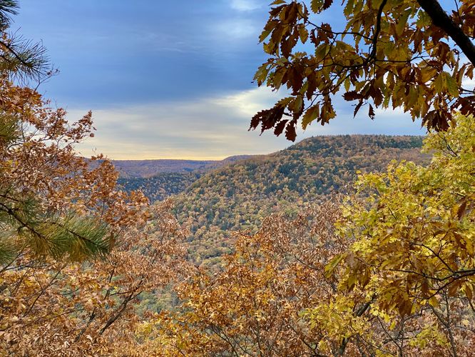
Sinnemahoning Canyon Vista (#1) - Mile 1.95
Hikers will reach the first vista of Sinnemahoning Canyon around mile 1.95. Note that this view is located on the top of a very tall rock that plunges approximately 70-feet down along 3 sides. The crux of this view is located just before the last and short rock climb—watch your step. Once on the rock, hikers will get stunning views of the Sinnemahoning Canyon, Sinnemahoning Creek, and the mountain ridges located across the valley. This view is by far the best along the hike.
Reaching Sinnemahoning Canyon Vista #2 - Mile 1.95 to 2.3
From mile 1.95, hikers will head back up the shale mountain ridge. Before making your way all the way to the very-top of the mountain, hikers can follow the contour lines of the mountain - continuing to bushwhack through blueberry and teaberry - to reach the next mountain ridge, located just south. Hikers will notice a 2nd mountain ridge after making it through the bushwhack where the forest floor opens up once again. Hikers will head down this ridge to reach another rock outcropping where you'll find another view.
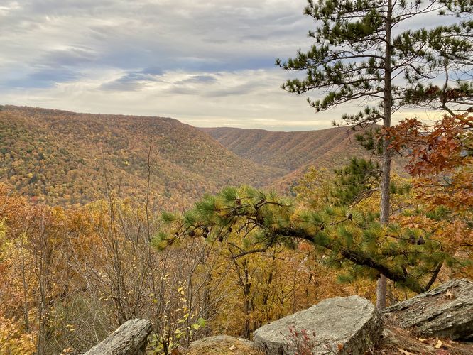
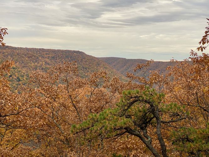
Sinnemahoning Canyon Vista (#2) - mile 2.3
Hikers will reach the 2nd vista of the Sinnemahoning Canyon and Sinnemahoning Creek around mile 2.3. Here, you'll find another rock outcropping, but this one is far-less dangerous than the previous with a ~15-foot drop on one side. The view here is a bit obstructed, but includes some beautiful pine trees that add to the scenery. Hikers can hang out here (with more room/space) before heading onward.
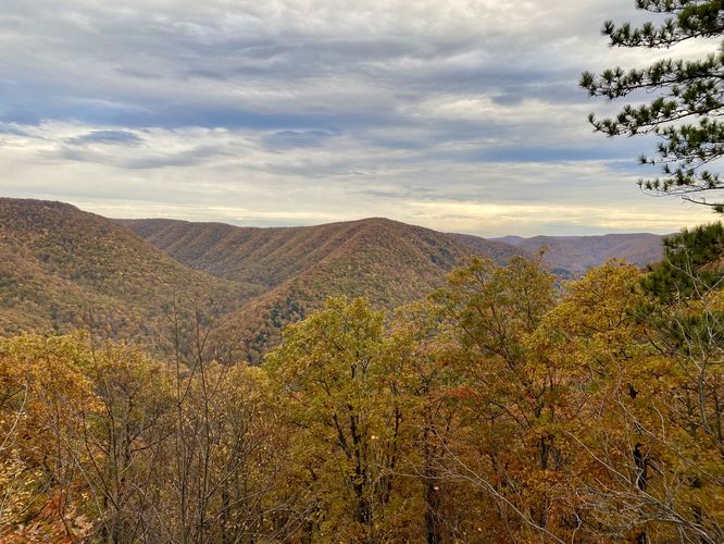
Reaching the Spine / Ridge Vistas (#3, #4) - Mile 2.3 to 2.6
Similar to the 1st mountain ridge, hikers will head up the ridge and then hike southeast to follow the contour lines to reach a mountain spine. Once on the mountain spine, hikers will find 2 more vistas: one around mile 2.56 (facing Eastward), and another around mile 2.6 (obstructed, facing Westward). Note that this mountain spine is not super interesting but provides some neat rock features along with the skinny path.
End of Public Land - Mile 2.67
Around mile 2.67, hikers will reach the end of public land - marked by a large white blaze which is the state forest boundary. Please stay off of private property, the hike turns around here.
Hiking Back - Mile 2.67 to 4.7
Once at the end of the public land section, hikers will turn around to hike out. This skinny mountain spine trail runs back toward the forest clearing where you first went off-trail. Note that this path "ends" between the clearing and the spine, so it's smart to use your offline mapping device to ensure you're heading in the right direction. Once on the trail, the hike out is opposite to the hike in.
Difficulty
Note that the physical difficulty of this hike should likely be considered "Moderate"; however, due to the nature of bushwhacking off-trail, in an area with very little to no cell service, in addition to steep mountain ridges, this hike should be cautioned as Moderate to Hard / Difficult for the average hiker.
Parking
Hikers will find a small parking turnout near the coordinates provided, located on Montour Road. This road does not have Winter maintenance. Winter begins here usually during early December with snow and ice building up on the roads.
Pets
Dogs are allowed if leashed and must be cleaned up after.
Camping & Backpacking
Camping and backpacking are permitted within Elk State Forest; however, there were no campsites along this hike. Note that the vistas lie within the Bucktail State Park Natural Area, which does not allow camping. If camping, please follow all state forest rules and regulations.
Warnings
Hunting: Note that hunting is allowed here during open season, generally between October and January each year. It's smart to wear blaze orange if hiking during hunting season.
Timber Rattlesnakes: This area is home to the Timber Rattlesnake which can be found roaming the forest floors between late April and early October each year. Be on the lookout and if found, give them plenty of space.
Lack of cell service: This hike does not have much cell coverage (Verizon) and most of the time it's nonexistent.
Steep terrain: This hike follows some steep mountainside terrain, including traversing onto a rocky outcropping with large 70-foot drops on each side. Watch your step and pay attention to where you're hiking when near steep or dangerous terrain.
Bushwhacking
Note that this hike includes bushwhacking; however, most of the forest floor is wide-open with the exception of many teaberry and blueberry bushes. My 22lbs dog had a fine time bushwhacking these small shrubs, but going off-trail is not for everyone. If planning on doing this hike, remember to bring an offline GPS tracker, like the MyHikes apps to find your way!
Hike Description
This hike begins along Montour Road (at the coordinates provided) and follows a gated service road from the parking area. Hikers will follow the service road until they reach the main pipeline - take a left-hand turn here to hike south along the pipeline.
Easy-to-Miss Left-Hand Turn - Mile 0.4
Around mile 0.4, on the pipeline, hikers will notice a small cutout within the pine trees - located on the east side of the pipeline. Look close enough to find an overgrown trail laden with mountain laurel - this is the trail you'll follow to reach the off-trail vistas.This trail leads out along the top of the mountain with very little undulation along the way.
"Dead End" - Mile 1.7
Around mile 1.7, hikers will reach a dead end in the trail - this is where the bushwhack begins. Using your offline mapping device, hikers can find their way by heading almost due-West from here. Hike through the open forest to find a mossy and shale-covered ridge that leads downhill. Follow this ridge to reach the main (and best view) - Sinnemahoning Canyon Vista (#1).
Sinnemahoning Canyon Vista (#1) - Mile 1.95
Hikers will reach the first vista of Sinnemahoning Canyon around mile 1.95. Note that this view is located on the top of a very tall rock that plunges approximately 70-feet down along 3 sides. The crux of this view is located just before the last and short rock climb—watch your step. Once on the rock, hikers will get stunning views of the Sinnemahoning Canyon, Sinnemahoning Creek, and the mountain ridges located across the valley. This view is by far the best along the hike.
Reaching Sinnemahoning Canyon Vista #2 - Mile 1.95 to 2.3
From mile 1.95, hikers will head back up the shale mountain ridge. Before making your way all the way to the very-top of the mountain, hikers can follow the contour lines of the mountain - continuing to bushwhack through blueberry and teaberry - to reach the next mountain ridge, located just south. Hikers will notice a 2nd mountain ridge after making it through the bushwhack where the forest floor opens up once again. Hikers will head down this ridge to reach another rock outcropping where you'll find another view.
Sinnemahoning Canyon Vista (#2) - mile 2.3
Hikers will reach the 2nd vista of the Sinnemahoning Canyon and Sinnemahoning Creek around mile 2.3. Here, you'll find another rock outcropping, but this one is far-less dangerous than the previous with a ~15-foot drop on one side. The view here is a bit obstructed, but includes some beautiful pine trees that add to the scenery. Hikers can hang out here (with more room/space) before heading onward.
Reaching the Spine / Ridge Vistas (#3, #4) - Mile 2.3 to 2.6
Similar to the 1st mountain ridge, hikers will head up the ridge and then hike southeast to follow the contour lines to reach a mountain spine. Once on the mountain spine, hikers will find 2 more vistas: one around mile 2.56 (facing Eastward), and another around mile 2.6 (obstructed, facing Westward). Note that this mountain spine is not super interesting but provides some neat rock features along with the skinny path.
End of Public Land - Mile 2.67
Around mile 2.67, hikers will reach the end of public land - marked by a large white blaze which is the state forest boundary. Please stay off of private property, the hike turns around here.
Hiking Back - Mile 2.67 to 4.7
Once at the end of the public land section, hikers will turn around to hike out. This skinny mountain spine trail runs back toward the forest clearing where you first went off-trail. Note that this path "ends" between the clearing and the spine, so it's smart to use your offline mapping device to ensure you're heading in the right direction. Once on the trail, the hike out is opposite to the hike in.
Difficulty
Note that the physical difficulty of this hike should likely be considered "Moderate"; however, due to the nature of bushwhacking off-trail, in an area with very little to no cell service, in addition to steep mountain ridges, this hike should be cautioned as Moderate to Hard / Difficult for the average hiker.
Parking
Hikers will find a small parking turnout near the coordinates provided, located on Montour Road. This road does not have Winter maintenance. Winter begins here usually during early December with snow and ice building up on the roads.
Pets
Dogs are allowed if leashed and must be cleaned up after.
Camping & Backpacking
Camping and backpacking are permitted within Elk State Forest; however, there were no campsites along this hike. Note that the vistas lie within the Bucktail State Park Natural Area, which does not allow camping. If camping, please follow all state forest rules and regulations.
Warnings
Hunting: Note that hunting is allowed here during open season, generally between October and January each year. It's smart to wear blaze orange if hiking during hunting season.
Timber Rattlesnakes: This area is home to the Timber Rattlesnake which can be found roaming the forest floors between late April and early October each year. Be on the lookout and if found, give them plenty of space.
Lack of cell service: This hike does not have much cell coverage (Verizon) and most of the time it's nonexistent.
Steep terrain: This hike follows some steep mountainside terrain, including traversing onto a rocky outcropping with large 70-foot drops on each side. Watch your step and pay attention to where you're hiking when near steep or dangerous terrain.