Shades of Death Trail (Waterfalls) at Hickory Run State Park in Kidder Township, Pennsylvania is an easy 1.7-mile out-and-back hike that features several waterfalls of varying height from 2 to 15-feet including Stametz Dam Falls.
Trails
This hike follows one named trail: Shades of Death Trail (yellow blazes).
Waterfalls
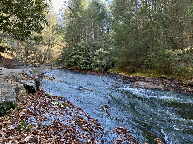
This hike passes several waterfalls within Sand Spring Run. The most noteworthy is the dam waterfall known as Stametz Dam Falls and is about 15-feet tall. The other noteworthy waterfall is located upstream, near the end of this trail, named Upper Sand Spring Falls and is a multi-tier cascade at about 15-feet tall as well. Sand Spring Run has a multitude of smaller waterfalls along the way including many 2-foot to 8-foot cascades, so be on the lookout during this hike.
Hike Description
This hike begins at the main parking lot and trailhead for the Shades of Death Trail, located along PA-534 just East of the Hickory Run State Park office. The main trailhead is on the East side of the parking lot and begins by heading into the dark-shaded forest filled with evergreens and rhododendron. The trail is mostly flat to begin but starts undulating quickly with a set of stairs that leads up and away from Sand Spring Run to follow a safer path near the road. The trail dips back into the forest to once again meet back up with Sand Spring Run.
Slide Waterfall, 8-feet tall, 150-feet long - Mile 0.2
At mile 0.2, hikers will reach a very long but short waterfall. This slide waterfall is almost silent as the creek's water quickly runs down the bedrock surface of this neat, but hard-to-photograph waterfall. The trail here also runs up along the side of the waterfall, following bedrock -- watch your step as to not accidentally slip on the trail here as it can often be wet from the creek.
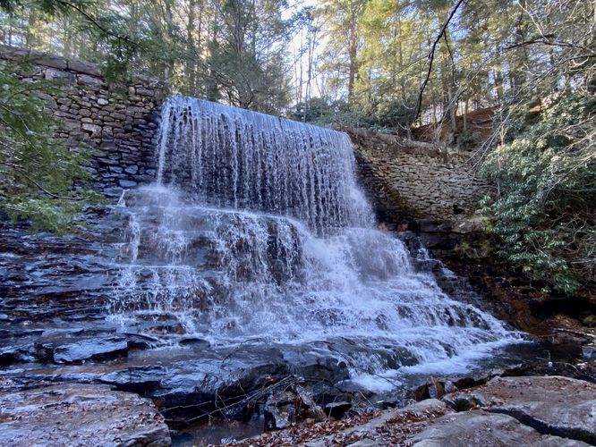
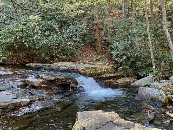
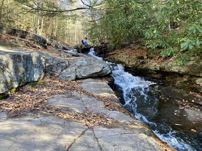
Stametz Dam Falls, 15-feet tall - Mile 0.3
Around mile 0.3, hikers will find the 15-foot tall Stametz Dam Falls that spills over from Stametz Pond. This human-made waterfall is by far the most-scenic along the trail. The area just below the waterfall is mostly exposed bedrock with several trees growing through, but it makes for a decent spot to sit and take a short break. Stametz Dam Falls is not the last waterfall to explore on this hike, so keep going to see more.
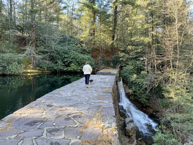
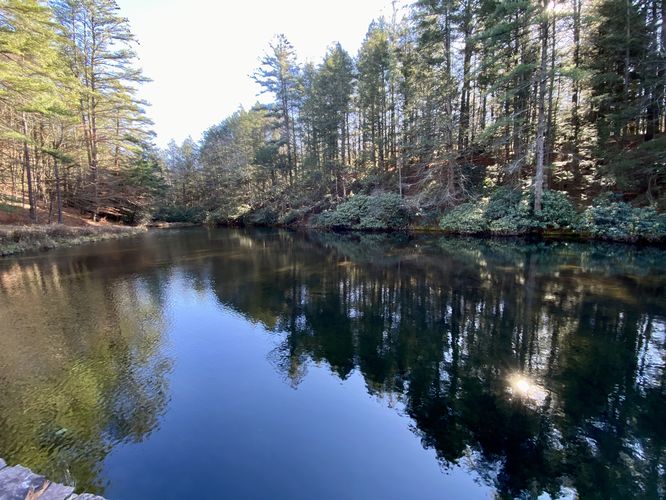
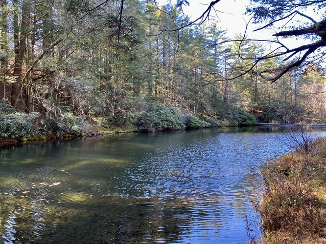
Stametz Dam & Pond Views - Mile 0.31
Just up the trail from Stametz Dam Falls it the dam that created Stametz Pond. Hikers can head out along this short walk along the dam to enjoy the dark-green hues of Stametz Pond that appear almost emerald in color. You can also get another interesting view of Stametz Dam Falls from the dam itself. The trail then skirts alongside Stamets Pond, providing hikers with even more views.
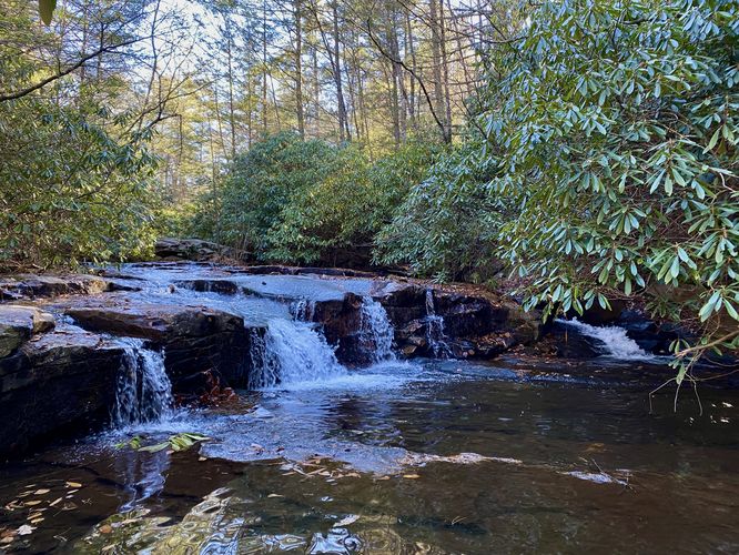
Three Short Waterfalls - Mile 0.43 to 0.45
At mile 0.43, hikers will find two short waterfalls -- both are about 2 or 3-feet tall at most. One is about 10-feet wide and they both sit in the creek alongside old rhododendrons. The last waterfall in this section of the trail is a ~6-foot tall cascade that can be found around mile 0.45, just around the corner from the previous. Watch your step in this section as the trail is rocky and sometimes slippery.
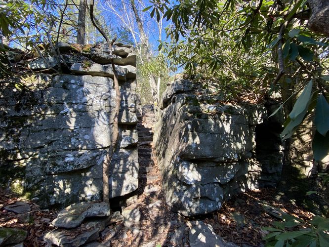
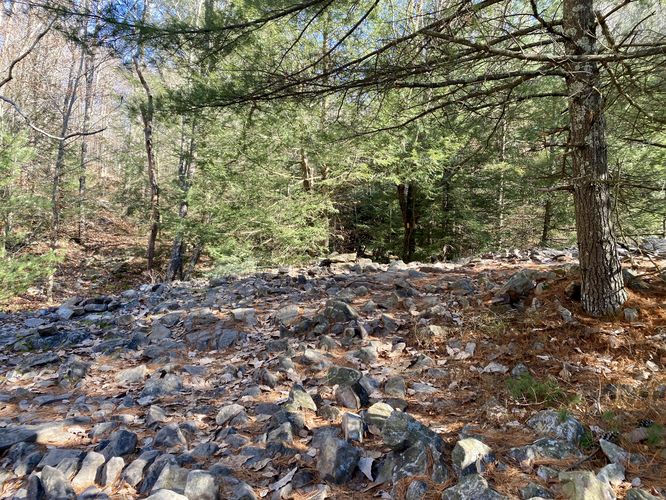
Bedrock Cutout & Rocky Terrain - Mile 0.6 to 0.63
At mile 0.6, hikers will encounter a neat feature of the trail as it passes through bedrock in between two large rock outcroppings. The trail is even fitted with hued steps. Just around the corner from this bedrock pass-thru, the trail turns into a super-rocky path where it's pretty difficult to hike through. This section only lasts about 100-feet or so.
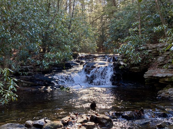
Upper Sand Spring Falls, 15-feet tall - Mile 0.8
Around mile 0.8, hikers will reach the last waterfall along this hike -- Upper Sand Spring Falls. Upper Sand Spring Falls cascades down the creek in several tiers, creating the ~15-foot waterfall. Upper Sand Spring Falls is the last waterfall stop along this hike, so take in the sights while you can.
This GPS track leads up beyond Upper Sand Spring Falls to reach the end of the trail before heading back to parking. Along the way back, be sure to enjoy the waterfalls once more as you never know when you might be back, if ever. Watch your step as you traverse the super-rocky terrain and take-in some of those emerald-green pond views back at Stametz Pond. Stametz Dam Falls can't be missed on the hike out either, so that's another chance to sit, relax, and enjoy that waterfall one more time too.
Parking
Hikers will find a medium-sized parking lot at the coordinates provided, located just East of the Hickory Run State Park office on PA-534 in Kidder Township. The lot is large enough to fit just over a dozen vehicles but less than two-dozen.
Pets
Dogs are allowed only if leashed and must be cleaned up after.
Warning
Slippery rocks: Parts of this trail runs adjacent to the creek which often makes the bedrock slick and slippery. Watch your step.
Rocky terrain: A small section of this trail passes through areas of very rocky terrain. Watch your step.
Trails
This hike follows one named trail: Shades of Death Trail (yellow blazes).
Waterfalls
This hike passes several waterfalls within Sand Spring Run. The most noteworthy is the dam waterfall known as Stametz Dam Falls and is about 15-feet tall. The other noteworthy waterfall is located upstream, near the end of this trail, named Upper Sand Spring Falls and is a multi-tier cascade at about 15-feet tall as well. Sand Spring Run has a multitude of smaller waterfalls along the way including many 2-foot to 8-foot cascades, so be on the lookout during this hike.
Hike Description
This hike begins at the main parking lot and trailhead for the Shades of Death Trail, located along PA-534 just East of the Hickory Run State Park office. The main trailhead is on the East side of the parking lot and begins by heading into the dark-shaded forest filled with evergreens and rhododendron. The trail is mostly flat to begin but starts undulating quickly with a set of stairs that leads up and away from Sand Spring Run to follow a safer path near the road. The trail dips back into the forest to once again meet back up with Sand Spring Run.
Slide Waterfall, 8-feet tall, 150-feet long - Mile 0.2
At mile 0.2, hikers will reach a very long but short waterfall. This slide waterfall is almost silent as the creek's water quickly runs down the bedrock surface of this neat, but hard-to-photograph waterfall. The trail here also runs up along the side of the waterfall, following bedrock -- watch your step as to not accidentally slip on the trail here as it can often be wet from the creek.
Stametz Dam Falls, 15-feet tall - Mile 0.3
Around mile 0.3, hikers will find the 15-foot tall Stametz Dam Falls that spills over from Stametz Pond. This human-made waterfall is by far the most-scenic along the trail. The area just below the waterfall is mostly exposed bedrock with several trees growing through, but it makes for a decent spot to sit and take a short break. Stametz Dam Falls is not the last waterfall to explore on this hike, so keep going to see more.
Stametz Dam & Pond Views - Mile 0.31
Just up the trail from Stametz Dam Falls it the dam that created Stametz Pond. Hikers can head out along this short walk along the dam to enjoy the dark-green hues of Stametz Pond that appear almost emerald in color. You can also get another interesting view of Stametz Dam Falls from the dam itself. The trail then skirts alongside Stamets Pond, providing hikers with even more views.
Three Short Waterfalls - Mile 0.43 to 0.45
At mile 0.43, hikers will find two short waterfalls -- both are about 2 or 3-feet tall at most. One is about 10-feet wide and they both sit in the creek alongside old rhododendrons. The last waterfall in this section of the trail is a ~6-foot tall cascade that can be found around mile 0.45, just around the corner from the previous. Watch your step in this section as the trail is rocky and sometimes slippery.
Bedrock Cutout & Rocky Terrain - Mile 0.6 to 0.63
At mile 0.6, hikers will encounter a neat feature of the trail as it passes through bedrock in between two large rock outcroppings. The trail is even fitted with hued steps. Just around the corner from this bedrock pass-thru, the trail turns into a super-rocky path where it's pretty difficult to hike through. This section only lasts about 100-feet or so.
Upper Sand Spring Falls, 15-feet tall - Mile 0.8
Around mile 0.8, hikers will reach the last waterfall along this hike -- Upper Sand Spring Falls. Upper Sand Spring Falls cascades down the creek in several tiers, creating the ~15-foot waterfall. Upper Sand Spring Falls is the last waterfall stop along this hike, so take in the sights while you can.
This GPS track leads up beyond Upper Sand Spring Falls to reach the end of the trail before heading back to parking. Along the way back, be sure to enjoy the waterfalls once more as you never know when you might be back, if ever. Watch your step as you traverse the super-rocky terrain and take-in some of those emerald-green pond views back at Stametz Pond. Stametz Dam Falls can't be missed on the hike out either, so that's another chance to sit, relax, and enjoy that waterfall one more time too.
Parking
Hikers will find a medium-sized parking lot at the coordinates provided, located just East of the Hickory Run State Park office on PA-534 in Kidder Township. The lot is large enough to fit just over a dozen vehicles but less than two-dozen.
Pets
Dogs are allowed only if leashed and must be cleaned up after.
Warning
Slippery rocks: Parts of this trail runs adjacent to the creek which often makes the bedrock slick and slippery. Watch your step.
Rocky terrain: A small section of this trail passes through areas of very rocky terrain. Watch your step.