The Sawyer Mountain & High Pasture Loop at Sawyer Mountain Highlands near Limington, Maine is a moderate 4.6-mile loop hike that features views from Sawyer Mountain while passing two summits.
Trails
This loop follows several named trails in the following order: Sherwood Libby Trail (orange blazes), New Skidway Road, Sawyer Mountain Road (red blazes).
Hiking Sawyer Mountain
This hike begins at the main trailhead parking lot and follows the route in a clockwise loop. Note that the terrain on the Sawyer Mountain Road Trail is far more annoying than the Sherwood Libby Trail due to an excessive amount of creekbed rocks that you'll have to hike on. If you want to get that out of the way first, it's recommended to hike this loop counter-clockwise instead.
Trailhead to High Pasture Summit - Mile 0 to 1.25
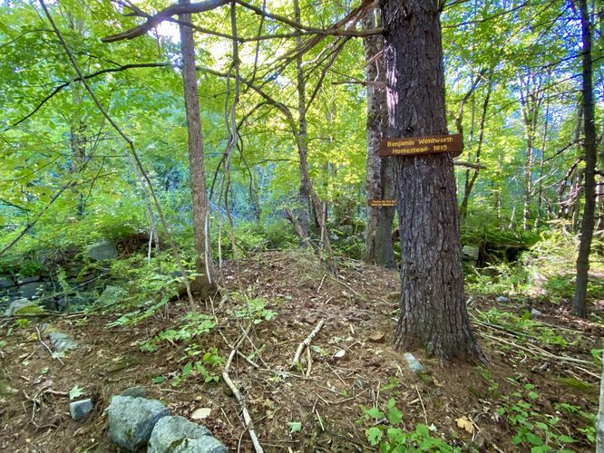
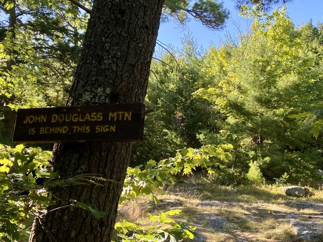
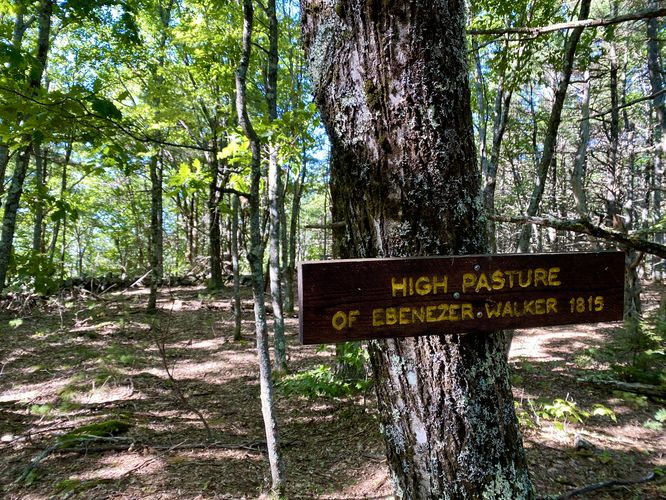
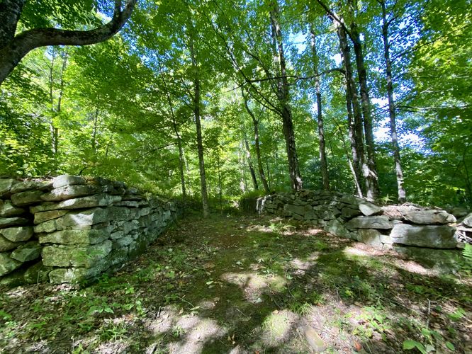
From the trailhead, heading clockwise, the hike follows the Sherwood Libby Trail to begin (keep left at the trailhead) and first passed an old homestead once owned by a man named Benjamin Wentworth in 1815. Beyond the old foundation, the trail leads further into the forest as it meanders south before taking a 90-degree right-hand turn to begin your ascent toward John Douglas Mountain. The hike up toward John Douglas Mountain is not difficult but follows a moderate grade, which gets the heart pumping. Near the top of John Douglas Mountain is a sign labeling its summit, which is located several-hundred feet off-trail in the woods. The trail continues uphill from this point and passed a rocky outcropping as it ascends High Pasture. Hikers will enter the top of High Pasture summit around mile 1.13 where you'll pass an old stone wall that once defined a property fence. Hikers will reach the "summit" of High Pasture mountain around mile 1.25 which has a sign marking the location labeled "High Pasture of Ebenezer Walker (1815)".
High Pasture to Sawyer Mountain Overlook - Mile 1.25 to 2.4
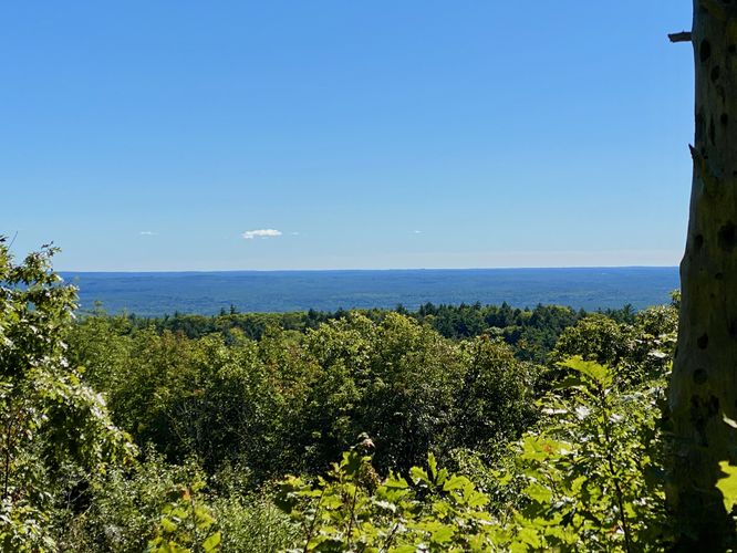
The hike to reach the main overlook on Sawyer Mountain leads hikers uphill once more from High Pasture, but first you must hike downhill for about 180 vertical feet. The hike back up Sawyer Mountain follows the Sherwood Libby Trail until you reach a service road that cuts south -- take a left-hand turn onto the service road (New Skidway Road) to follow this trail as it ascends Sawyer Mountain, but just make sure you keep-right as you hike up and follow "Overlook" signs. Hikers will eventually reach flatter terrain around mile 2.3 where you'll want to keep-left to head out toward the view. At mile 2.34, hikers will reach the main overlook with provides a scenic view of the mountainous plateau at your feet. The trail continues out toward a rocky outcropping, located around mile 2.4, that provides a somewhat-obstructed but scenic view of a couple of nearby mountains. Back at the Sawyer Mountain Overlook, hikers will find a picnic table where you can chill out and enjoy the view before hiking onward.
Hike to Sawyer Mountain Summit - Mile 2.4 to 2.65
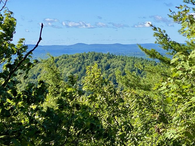
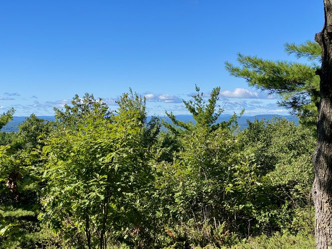
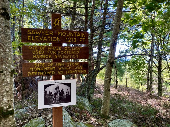
The hike up to Sawyer Mountain's summit, from the overlook, is fairly straight forward -- hikers will head back to the main trail and instead of hiking down, take a left-hand turn to continue hiking up. The ascent to Sawyer Mountain's summit is not difficult and doesn't last long. Around mile 2.6, you'll reach the summit where you might find other hikers sitting and enjoying the mountain. From the summit there are some views, albeit mostly-obstructed, but you can find other neighboring mountains on the horizon from here. Just beyond, around mile 2.66 is a Sawyer Mountain Summit sign which denotes the "summit".
Hiking Sawyer Mountain Road to Parking - Mile 2.65 to 4.6
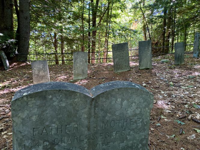
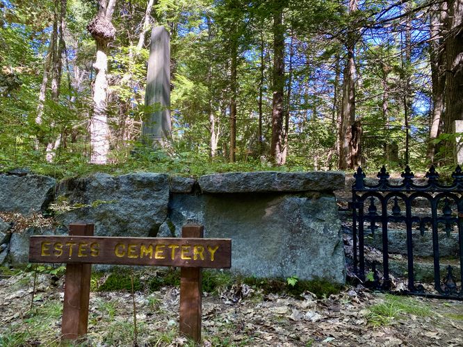
The hike out from Sawyer Mountain's summit is fairly straight forward, especially if you have an offline tracking device. Hikers will follow signs for "Sawyer Mountain Road" which leads to the red-blazed old forest road. This road is a bit confusing -- a good portion of the road follows an old creek bed with a ton of rocks that can easily roll your ankles. The rocky terrain begins around mile 3 and ends around mile 3.35, which sounds short but feels like it lasts forever. Second, the road passes private camps which are accessible via junction roads, so you may see authorized vehicles driving through. Last, the trail passes several old cemeteries and homestead sites from the 1800s. Around mile 3.4 is an old barn foundation located off-trail, 3.45 is the old McKenney Cemetery, and mile 3.65 is the old Estes Cemetery. The trail continues through the forest to eventually end around mile 4.6 at the parking lot to complete this moderate hike on Sawyer Mountain.
Parking
Hikers will find a large parking lot at the coordinates provided, located on the west side of Cape Road in Limington, Maine. The lot is large enough to fit over a dozen vehicles as of September 2024.
Pets
Dogs are allowed only if leashed and must be cleaned up after.
Trails
This loop follows several named trails in the following order: Sherwood Libby Trail (orange blazes), New Skidway Road, Sawyer Mountain Road (red blazes).
Hiking Sawyer Mountain
This hike begins at the main trailhead parking lot and follows the route in a clockwise loop. Note that the terrain on the Sawyer Mountain Road Trail is far more annoying than the Sherwood Libby Trail due to an excessive amount of creekbed rocks that you'll have to hike on. If you want to get that out of the way first, it's recommended to hike this loop counter-clockwise instead.
Trailhead to High Pasture Summit - Mile 0 to 1.25
From the trailhead, heading clockwise, the hike follows the Sherwood Libby Trail to begin (keep left at the trailhead) and first passed an old homestead once owned by a man named Benjamin Wentworth in 1815. Beyond the old foundation, the trail leads further into the forest as it meanders south before taking a 90-degree right-hand turn to begin your ascent toward John Douglas Mountain. The hike up toward John Douglas Mountain is not difficult but follows a moderate grade, which gets the heart pumping. Near the top of John Douglas Mountain is a sign labeling its summit, which is located several-hundred feet off-trail in the woods. The trail continues uphill from this point and passed a rocky outcropping as it ascends High Pasture. Hikers will enter the top of High Pasture summit around mile 1.13 where you'll pass an old stone wall that once defined a property fence. Hikers will reach the "summit" of High Pasture mountain around mile 1.25 which has a sign marking the location labeled "High Pasture of Ebenezer Walker (1815)".
High Pasture to Sawyer Mountain Overlook - Mile 1.25 to 2.4
The hike to reach the main overlook on Sawyer Mountain leads hikers uphill once more from High Pasture, but first you must hike downhill for about 180 vertical feet. The hike back up Sawyer Mountain follows the Sherwood Libby Trail until you reach a service road that cuts south -- take a left-hand turn onto the service road (New Skidway Road) to follow this trail as it ascends Sawyer Mountain, but just make sure you keep-right as you hike up and follow "Overlook" signs. Hikers will eventually reach flatter terrain around mile 2.3 where you'll want to keep-left to head out toward the view. At mile 2.34, hikers will reach the main overlook with provides a scenic view of the mountainous plateau at your feet. The trail continues out toward a rocky outcropping, located around mile 2.4, that provides a somewhat-obstructed but scenic view of a couple of nearby mountains. Back at the Sawyer Mountain Overlook, hikers will find a picnic table where you can chill out and enjoy the view before hiking onward.
Hike to Sawyer Mountain Summit - Mile 2.4 to 2.65
The hike up to Sawyer Mountain's summit, from the overlook, is fairly straight forward -- hikers will head back to the main trail and instead of hiking down, take a left-hand turn to continue hiking up. The ascent to Sawyer Mountain's summit is not difficult and doesn't last long. Around mile 2.6, you'll reach the summit where you might find other hikers sitting and enjoying the mountain. From the summit there are some views, albeit mostly-obstructed, but you can find other neighboring mountains on the horizon from here. Just beyond, around mile 2.66 is a Sawyer Mountain Summit sign which denotes the "summit".
Hiking Sawyer Mountain Road to Parking - Mile 2.65 to 4.6
The hike out from Sawyer Mountain's summit is fairly straight forward, especially if you have an offline tracking device. Hikers will follow signs for "Sawyer Mountain Road" which leads to the red-blazed old forest road. This road is a bit confusing -- a good portion of the road follows an old creek bed with a ton of rocks that can easily roll your ankles. The rocky terrain begins around mile 3 and ends around mile 3.35, which sounds short but feels like it lasts forever. Second, the road passes private camps which are accessible via junction roads, so you may see authorized vehicles driving through. Last, the trail passes several old cemeteries and homestead sites from the 1800s. Around mile 3.4 is an old barn foundation located off-trail, 3.45 is the old McKenney Cemetery, and mile 3.65 is the old Estes Cemetery. The trail continues through the forest to eventually end around mile 4.6 at the parking lot to complete this moderate hike on Sawyer Mountain.
Parking
Hikers will find a large parking lot at the coordinates provided, located on the west side of Cape Road in Limington, Maine. The lot is large enough to fit over a dozen vehicles as of September 2024.
Pets
Dogs are allowed only if leashed and must be cleaned up after.