The Royalston Falls hike at Royalston State Forest in Royalston, Massachusetts is a moderate 2-mile out-and-back hike that leads to the 60-foot tall free-falling waterfall, Royalston Falls, and features a peaceful hike through the woods along a stream named Falls Brook.
Trail Description
Hikers will begins at the small parking lot next to the Newton Cemetery. The trailhead hikers follow is blazed with both yellow and white blazes, but hikers will mainly be following yellow all the way to Royalston Falls. The trails followed here are the New England Trail, M & M Trail, and the Tully Trail - please note that all of these named trails follow the same route at least for this short section hike.
Hikers will head down a mostly-flat trail for 0.16 miles before reaching a junction in the trail. In our guide, we took a right-hand turn here, but both paths lead to the same place. To save time, hikers can take a left-hand turn at the 1st trail junction to speed up their hike.
After passing the 1st junction, hikers will reach yet another fork in the trail - this junction is where the original paths that diverged meet once again. In our guide, we stay right at this 2nd junction. If you decided to stay left at the 1st trail junction, stay left at the 2nd as well. At the 2nd trail junction, hikers will head down along a steeper hill until reaching Falls Brook.
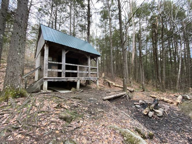
Backpacking Shelter
At Falls Brook, around mile 0.6, hikers and backpackers will find a shelter that can hold about 5 or 6 people in total. This shelter is a first-come first-serve shelter for overnight backpackers along the Tully Trail.
Falls Brook Bridge Crossing
Just after the backpacking shelter, hikers will have to cross the Falls Brook bridge. During wet months this bridge can be very slippery so hike at your own caution.
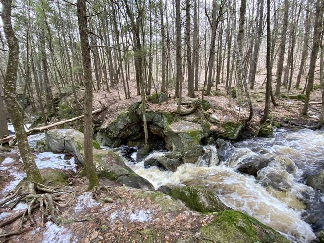
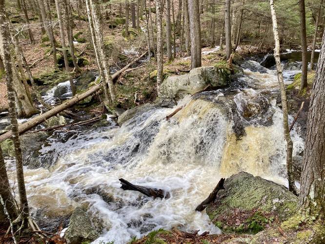
After crossing the Falls Brook bridge, hikers will take a right-hand turn to hike south along Falls Brook - passing several smaller waterfalls - before reaching Royalston Falls. This section of trail is mostly-easy to hike unless during the winter or very cold months when ice builds up between the rocks that jut out from the ground. It's advised to bring ice spikes on this trail during the winter and cold months to ensure your safety.
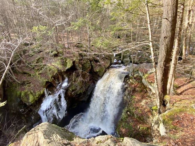
Reaching Royalston Falls
Hikers will first need to pass about 3 smaller waterfalls, including a wide pool where the stream widens, to reach Royalston Falls. After approximately 0.5-miles from the Falls Brook crossing, hikers will finally reach Royalston Falls, which free-falls down Falls Brook at about 60-feet tall and 10-feet wide. The viewing area along the waterfall is extremely dangerous but has 3 thick steel cables acting as a fence to keep hikers safe. The waterfall can be enjoyed from several angles, but without a wide-angle camera you usually cannot get a full picture of the entire waterfall.
Hiking Back
The hike back to parking is identical to the trek to Royalston Falls, but in the opposite direction.
Parking
Hikers will find a small parking lot at the coordinates provided next to the trailhead along the Tully Trail and New England Trail. This parking lot fills up quickly on the weekends, so show up early for a spot. The parking lot is large enough to fit about 5 cars comfortably. As of December 2020, there's an additional small parking area next to MA Route 32 next to the parking area that can accommodate a few extra vehicles.
Pets
Dogs are allowed if leashed.
Difficulty
This hike should be considered moderate even for the experienced hiker considering the elevation gain on the hike back to parking and the uneven rocks that jut up through the ground along the Falls Brook portion of this hike.
Camping and Backpacking
Backpackers will find a large shelter around mile 0.6 on the way in to the waterfall. This shelter sits along the western side of Falls Brook, which provides plenty of filterable water. Please follow all rules and regulations for backpacking the Tully Trail while camping/backpacking at this shelter.
Dangers
The cliffs next to Royalston Falls are extremely dangerous - watch your step, take your time, and hike at your own risk. Falling from the ledges at Royalston Falls will easily result in serious injury if not death.
Winter Hiking
Hikers should note a few things if planning to hike this trail during the winter and cold months. 1st, bring ice spikes as the steep section of trail is often, but not always, sheer ice leading downhill for 0.1-miles or so. Without ice spikes, that section of trail is impassible unless the ice has melted because of warmer weather, rain, or both. 2nd, the ice along the Falls Brook portion of the trail is a pain even in low-ice conditions. Last, it's very easy to slip off of the Falls Brook crossing bridge, so ice spikes help with that as well.
Trail Description
Hikers will begins at the small parking lot next to the Newton Cemetery. The trailhead hikers follow is blazed with both yellow and white blazes, but hikers will mainly be following yellow all the way to Royalston Falls. The trails followed here are the New England Trail, M & M Trail, and the Tully Trail - please note that all of these named trails follow the same route at least for this short section hike.
Hikers will head down a mostly-flat trail for 0.16 miles before reaching a junction in the trail. In our guide, we took a right-hand turn here, but both paths lead to the same place. To save time, hikers can take a left-hand turn at the 1st trail junction to speed up their hike.
After passing the 1st junction, hikers will reach yet another fork in the trail - this junction is where the original paths that diverged meet once again. In our guide, we stay right at this 2nd junction. If you decided to stay left at the 1st trail junction, stay left at the 2nd as well. At the 2nd trail junction, hikers will head down along a steeper hill until reaching Falls Brook.
Backpacking Shelter
At Falls Brook, around mile 0.6, hikers and backpackers will find a shelter that can hold about 5 or 6 people in total. This shelter is a first-come first-serve shelter for overnight backpackers along the Tully Trail.
Falls Brook Bridge Crossing
Just after the backpacking shelter, hikers will have to cross the Falls Brook bridge. During wet months this bridge can be very slippery so hike at your own caution.
After crossing the Falls Brook bridge, hikers will take a right-hand turn to hike south along Falls Brook - passing several smaller waterfalls - before reaching Royalston Falls. This section of trail is mostly-easy to hike unless during the winter or very cold months when ice builds up between the rocks that jut out from the ground. It's advised to bring ice spikes on this trail during the winter and cold months to ensure your safety.
Reaching Royalston Falls
Hikers will first need to pass about 3 smaller waterfalls, including a wide pool where the stream widens, to reach Royalston Falls. After approximately 0.5-miles from the Falls Brook crossing, hikers will finally reach Royalston Falls, which free-falls down Falls Brook at about 60-feet tall and 10-feet wide. The viewing area along the waterfall is extremely dangerous but has 3 thick steel cables acting as a fence to keep hikers safe. The waterfall can be enjoyed from several angles, but without a wide-angle camera you usually cannot get a full picture of the entire waterfall.
Hiking Back
The hike back to parking is identical to the trek to Royalston Falls, but in the opposite direction.
Parking
Hikers will find a small parking lot at the coordinates provided next to the trailhead along the Tully Trail and New England Trail. This parking lot fills up quickly on the weekends, so show up early for a spot. The parking lot is large enough to fit about 5 cars comfortably. As of December 2020, there's an additional small parking area next to MA Route 32 next to the parking area that can accommodate a few extra vehicles.
Pets
Dogs are allowed if leashed.
Difficulty
This hike should be considered moderate even for the experienced hiker considering the elevation gain on the hike back to parking and the uneven rocks that jut up through the ground along the Falls Brook portion of this hike.
Camping and Backpacking
Backpackers will find a large shelter around mile 0.6 on the way in to the waterfall. This shelter sits along the western side of Falls Brook, which provides plenty of filterable water. Please follow all rules and regulations for backpacking the Tully Trail while camping/backpacking at this shelter.
Dangers
The cliffs next to Royalston Falls are extremely dangerous - watch your step, take your time, and hike at your own risk. Falling from the ledges at Royalston Falls will easily result in serious injury if not death.
Winter Hiking
Hikers should note a few things if planning to hike this trail during the winter and cold months. 1st, bring ice spikes as the steep section of trail is often, but not always, sheer ice leading downhill for 0.1-miles or so. Without ice spikes, that section of trail is impassible unless the ice has melted because of warmer weather, rain, or both. 2nd, the ice along the Falls Brook portion of the trail is a pain even in low-ice conditions. Last, it's very easy to slip off of the Falls Brook crossing bridge, so ice spikes help with that as well.