The Quimby Trail at the Kittery Town Farm Forest in Kittery, Maine is an easy 1.2-mile one-way trail that passes through the entirety of this tract of of the town forest and features a historical gravesite, including the grave of Captain John R. Haley.
Trail Description
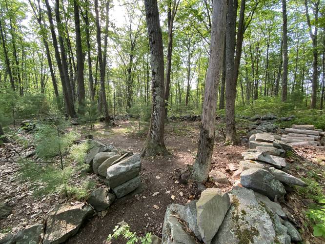
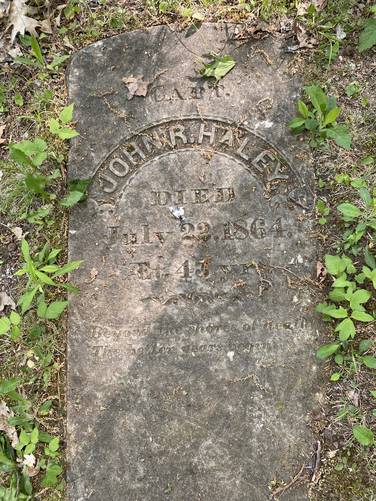
This recording of the Quimby Trail begins at the southern trailhead and makes its way along the blue blazes headed toward the northern parking lot. Along the way, hikers will find a small cemetery - the Haley Family Cemetery - that includes the gravesite of Captain John R. Haley - who died on July 22, 1864. There are several other gravesites in this cemetery and the signage near the trailhead indicates there are many unmarked graves located throughout the property.
The Quimby Trail winds around the forest in a manner that's a little bit annoying. When you think you're getting closer to the end of the trail, it again winds around to keep you from reaching your final goal - the opposite parking lot; however, once you get there, the trek back begins which hikers can take a shorter hike back along the Haley Trail (yellow blazes).
Parking
Hikers will find parking at both ends of this trail. Both parking lots can fit about a half-dozen vehicles or so, as of May 2021.
Pets
Dogs are allowed if leashed and their waste must be carried out by the hiker.
Blaze Color
The Quimby Trail follows blue blazes as of May 2021.
History
This land used to be part of the Kittery Alms House. Earliest Kittery Town records mention the Alms House in the 1875-1876 Auditor's Report. The building and land provided a home for residents who had fallen on hard times. They grew their own crops and raised some farm animals. Some time later the name was changed to the Poor Farm and then the Town Farm. It continued to provide for the residents needs through World War II until 1961, when the town spent $500 to have the building demolished. The land was then renamed to the Kittery Town Farm Forest and opened to all residents to enjoy as a natural area. The Haley family cemetery and many unmarked graves are located within the Town Forest.
Trail Description
This recording of the Quimby Trail begins at the southern trailhead and makes its way along the blue blazes headed toward the northern parking lot. Along the way, hikers will find a small cemetery - the Haley Family Cemetery - that includes the gravesite of Captain John R. Haley - who died on July 22, 1864. There are several other gravesites in this cemetery and the signage near the trailhead indicates there are many unmarked graves located throughout the property.
The Quimby Trail winds around the forest in a manner that's a little bit annoying. When you think you're getting closer to the end of the trail, it again winds around to keep you from reaching your final goal - the opposite parking lot; however, once you get there, the trek back begins which hikers can take a shorter hike back along the Haley Trail (yellow blazes).
Parking
Hikers will find parking at both ends of this trail. Both parking lots can fit about a half-dozen vehicles or so, as of May 2021.
Pets
Dogs are allowed if leashed and their waste must be carried out by the hiker.
Blaze Color
The Quimby Trail follows blue blazes as of May 2021.
History
This land used to be part of the Kittery Alms House. Earliest Kittery Town records mention the Alms House in the 1875-1876 Auditor's Report. The building and land provided a home for residents who had fallen on hard times. They grew their own crops and raised some farm animals. Some time later the name was changed to the Poor Farm and then the Town Farm. It continued to provide for the residents needs through World War II until 1961, when the town spent $500 to have the building demolished. The land was then renamed to the Kittery Town Farm Forest and opened to all residents to enjoy as a natural area. The Haley family cemetery and many unmarked graves are located within the Town Forest.