The Queen's Bath Trail in Princeville, Hawaii (Kauai) is a extremely-popular moderate 0.6-mile out-and-back trail that leads to the scenic, but very dangerous northern coastal cliffs and tide pool, Queen's Bath. This recording leads to the first tide pool with a waterfall that spills down into the ocean; however, it does not lead directly to Queen's Bath which is located 0.1-miles west of where this ends.
Death/Injury Warning
Note that over 30 people have died here, likely from unexpected waves crashing ashore and washing people out to sea or from people swimming within the tide pool and accidentally drowning due to strong waves. Hikers and visitors must be aware of the dangers before heading out. It's recommended to never turn your back to the ocean and to not stand close to the edge of the cliffs since massive waves could accidentally sweep you out to sea. It's also recommended to not actually swim here because there are no lifeguards on duty and the current and waves can be extremely dangerous. This news article, posted a few weeks after my visit, explains why.
Hike Description
The trail begins right at the parking lot and passes a metal gate where it heads downhill along slick compacted Kauai red dirt. Right at the trailhead are many warning signs about why people should not swim here, please read the signs to understand why without unknowingly hiking this trail.
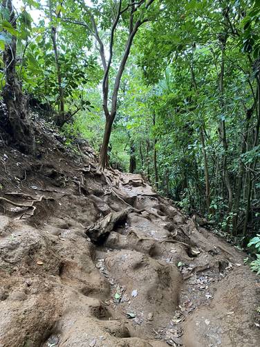
The trail heads downhill along a moderate to semi-steep grade in some places as it passes through Kauai's lush northern rainforest. Along the way hikers will find insanely-deep ruts and grooves in the trail that appear to be formed by people's feet. These ruts can be as deep as 2-feet, which could cause serious injury if you take a hard fall. Take your time and bring trekking poles to aid in the trail's uneven and rutted terrain.
Waterfall View - Mile 0.16
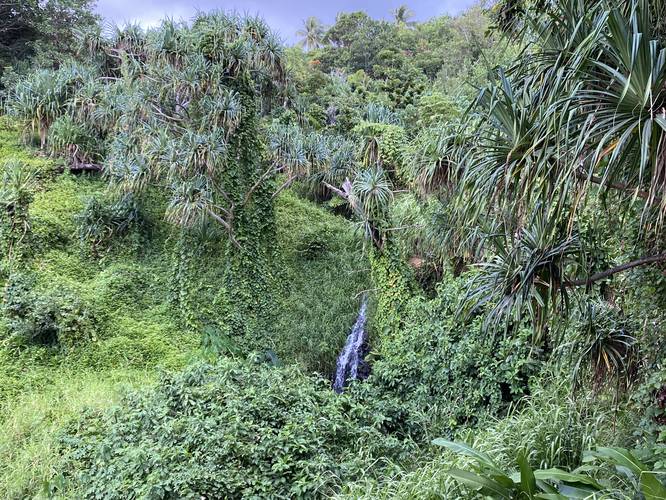
At mile 0.16, hikers will reach a nice view point where you can find a ~10-foot tall waterfall cascading down the nearby stream.
Right-hand Turn - Mile 0.18
Just after the waterfall view, hikers will reach a turn in the trail with a sign. This sign mentions to keep right here to avoid walking through fragile seabird nests. Staying right here will lead down a slightly-more steep grade where the trail finally "ends" at the coastal cliffs.
Coastal Cliffs, Waterfall, and Carved Bench - Mile 0.22 to 0.3
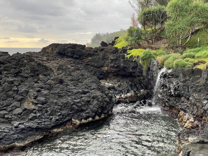
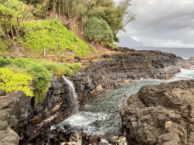
At mile 0.22, hikers will reach the "end" of the trail. The stream that hikers walked alongside ends here too - with some small waterfalls, approximately 4-feet tall, cascading down the stream next to the trail and a nice 10-foot cascade that spills into a tide pool. Here, to reach Queen's Bath, hikers will want to head west for about 0.18-miles further. Right where the trail ends is a small wooden carved bench that can fit just one person. This bench, as of July 2022, had ~30 notches carved out to signify each death that's happened here. This is a stark reminder that a plan to have fun here can quickly lead to a devastating outcome. At mile 0.3, this recording ends because I got distracted during my hike with the waterfall cascading down from the rock ledge into the tide pool below. I mistakenly assumed this tide pool was Queen's Bath - which goes to show how excited I was after my 5th parking attempt here as I disregarded the map's labeling. Despite not seeing the true "Queen's Bath" tide pool, this tide pool with the waterfall was good enough for me and, in my opinion, may be more scenic than the popular Queen's Bath because Queen's Bath doesn't have a waterfall. Either way, if you wish to reach Queen's Bath, continue hiking for ~0.1-miles west of where this recording ends. Do not turn your back to the ocean and do not hike near the edge of the coastal cliffs.
Hiking Out
The hike out is obviously the opposite hike in; however, you should be aware of the slippery and slick terrain of the trail. Take your time and watch your footing along the deep ruts.
Parking (Important)
The parking lot is large enough to fit about 10 vehicles and is located on a residential street with no overflow parking. Apparently, visitors can pay to park at the Princeville Makai Golf Course, which is located down the street, to walk to the trailhead from 0.5-miles away. This parking lot took me 5 attempts to finally get a parking spot here, which I was able to snag at 6:30AM in July, 2022. After leaving, around 7:15AM, the lot still had a couple of empty spots.
Warning (Important)
Rutted trail: This trail should be hiked only in proper footwear and the hiker should ultimately consider using trekking poles to aid in the rugged, rutted, and rough terrain of the trail.
Deaths, waves, and injuries: Queen's Bath, including the cliffs and tide pools lead to it, is a beautiful place; however, waves can sneak up on people sweeping them out to sea. If hit by a wave, the force could send you tumbling onto lava rocks which could injure you more or even kill you instantly. Additionally, for anyone who's swept away by the ocean and survives that, there's a rip tide that pulls out to sea. Last, there are no lifeguards on duty here. If visiting, it's best to show up at low tide, never turn your back to the ocean, do not stand between the ocean and Queen's Bath (or any tide pool for that matter), and do not swim in Queen's Bath.
Popularity
This is by far one of the most hiked trails on Kauai - as indicated by the 2-foot deep ruts in the trail's dirt. During periods of heavy rain, this dirt becomes muddier; however, that hasn't stopped people from continuously hiking this trail, creating series of insanely-deep ruts. Additionally, the parking lot for this trail is very small - no more than ~10 vehicles can park at the trailhead and there's no overflow parking in this residential neighborhood. During my visit on Kauai it took me 5 attempts, on 5 separate days at different times, to get a parking spot - finally, I got a parking spot at 6:30AM on my 5th attempt. Was it worth it? I don't think so for myself, but I can see why people hike this trail - you get a beautiful view of northern Kauai (more-so at Queen's Bath), the tide pool is pretty, and the waterfalls along the way allow for different scenic sights without walking very far, even if you don't go all the way out to "Queen's Bath".
Respecting the Land
Hawaiian land is considered sacred to native Hawaiians and many locals, so please stay on-trail, take nothing but photos, and leave nothing but footprints. Respect the locals - don't stay for long and have a backup hike planned in case the parking lot is full.
Death/Injury Warning
Note that over 30 people have died here, likely from unexpected waves crashing ashore and washing people out to sea or from people swimming within the tide pool and accidentally drowning due to strong waves. Hikers and visitors must be aware of the dangers before heading out. It's recommended to never turn your back to the ocean and to not stand close to the edge of the cliffs since massive waves could accidentally sweep you out to sea. It's also recommended to not actually swim here because there are no lifeguards on duty and the current and waves can be extremely dangerous. This news article, posted a few weeks after my visit, explains why.
Hike Description
The trail begins right at the parking lot and passes a metal gate where it heads downhill along slick compacted Kauai red dirt. Right at the trailhead are many warning signs about why people should not swim here, please read the signs to understand why without unknowingly hiking this trail.
The trail heads downhill along a moderate to semi-steep grade in some places as it passes through Kauai's lush northern rainforest. Along the way hikers will find insanely-deep ruts and grooves in the trail that appear to be formed by people's feet. These ruts can be as deep as 2-feet, which could cause serious injury if you take a hard fall. Take your time and bring trekking poles to aid in the trail's uneven and rutted terrain.
Waterfall View - Mile 0.16
At mile 0.16, hikers will reach a nice view point where you can find a ~10-foot tall waterfall cascading down the nearby stream.
Right-hand Turn - Mile 0.18
Just after the waterfall view, hikers will reach a turn in the trail with a sign. This sign mentions to keep right here to avoid walking through fragile seabird nests. Staying right here will lead down a slightly-more steep grade where the trail finally "ends" at the coastal cliffs.
Coastal Cliffs, Waterfall, and Carved Bench - Mile 0.22 to 0.3
At mile 0.22, hikers will reach the "end" of the trail. The stream that hikers walked alongside ends here too - with some small waterfalls, approximately 4-feet tall, cascading down the stream next to the trail and a nice 10-foot cascade that spills into a tide pool. Here, to reach Queen's Bath, hikers will want to head west for about 0.18-miles further. Right where the trail ends is a small wooden carved bench that can fit just one person. This bench, as of July 2022, had ~30 notches carved out to signify each death that's happened here. This is a stark reminder that a plan to have fun here can quickly lead to a devastating outcome. At mile 0.3, this recording ends because I got distracted during my hike with the waterfall cascading down from the rock ledge into the tide pool below. I mistakenly assumed this tide pool was Queen's Bath - which goes to show how excited I was after my 5th parking attempt here as I disregarded the map's labeling. Despite not seeing the true "Queen's Bath" tide pool, this tide pool with the waterfall was good enough for me and, in my opinion, may be more scenic than the popular Queen's Bath because Queen's Bath doesn't have a waterfall. Either way, if you wish to reach Queen's Bath, continue hiking for ~0.1-miles west of where this recording ends. Do not turn your back to the ocean and do not hike near the edge of the coastal cliffs.
Hiking Out
The hike out is obviously the opposite hike in; however, you should be aware of the slippery and slick terrain of the trail. Take your time and watch your footing along the deep ruts.
Parking (Important)
The parking lot is large enough to fit about 10 vehicles and is located on a residential street with no overflow parking. Apparently, visitors can pay to park at the Princeville Makai Golf Course, which is located down the street, to walk to the trailhead from 0.5-miles away. This parking lot took me 5 attempts to finally get a parking spot here, which I was able to snag at 6:30AM in July, 2022. After leaving, around 7:15AM, the lot still had a couple of empty spots.
Warning (Important)
Rutted trail: This trail should be hiked only in proper footwear and the hiker should ultimately consider using trekking poles to aid in the rugged, rutted, and rough terrain of the trail.
Deaths, waves, and injuries: Queen's Bath, including the cliffs and tide pools lead to it, is a beautiful place; however, waves can sneak up on people sweeping them out to sea. If hit by a wave, the force could send you tumbling onto lava rocks which could injure you more or even kill you instantly. Additionally, for anyone who's swept away by the ocean and survives that, there's a rip tide that pulls out to sea. Last, there are no lifeguards on duty here. If visiting, it's best to show up at low tide, never turn your back to the ocean, do not stand between the ocean and Queen's Bath (or any tide pool for that matter), and do not swim in Queen's Bath.
Popularity
This is by far one of the most hiked trails on Kauai - as indicated by the 2-foot deep ruts in the trail's dirt. During periods of heavy rain, this dirt becomes muddier; however, that hasn't stopped people from continuously hiking this trail, creating series of insanely-deep ruts. Additionally, the parking lot for this trail is very small - no more than ~10 vehicles can park at the trailhead and there's no overflow parking in this residential neighborhood. During my visit on Kauai it took me 5 attempts, on 5 separate days at different times, to get a parking spot - finally, I got a parking spot at 6:30AM on my 5th attempt. Was it worth it? I don't think so for myself, but I can see why people hike this trail - you get a beautiful view of northern Kauai (more-so at Queen's Bath), the tide pool is pretty, and the waterfalls along the way allow for different scenic sights without walking very far, even if you don't go all the way out to "Queen's Bath".
Respecting the Land
Hawaiian land is considered sacred to native Hawaiians and many locals, so please stay on-trail, take nothing but photos, and leave nothing but footprints. Respect the locals - don't stay for long and have a backup hike planned in case the parking lot is full.