Pulpit Rock and The Pinnacle via AT in Hamburg, Pennsylvania is a difficult 8.4-mile loop hike that features stunning panoramic views from cliff overlooks along one of Pennsylvania's most-popular day hike.
Trails
Reservoir Road, Appalachian Trail (white blazes), Furnace Creek Trail (blue blazes).
Hike
This hike begins at the main trailhead located at the end of Reservoir Road and follows the crushed stone service road that connects to the Appalachian Trail.
AT to Pulpit Rock - Mile 0.45
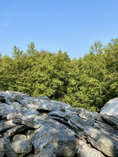
At mile 0.45, hikers will take a right-hand turn on the Appalachian Trail (white blazes) to hike up to Pulpit Rock. You'll want to keep-right at the following trail junction to stay on the AT, near mile 0.5. Once on the AT, the hike up to Pulpit Rock is fairly easy at first -- the trail follows a rocky path with a moderate grade for approximately 0.9-miles before the real ascent begins. Around mile 1.45, the hike up to Pulpit Rock becomes a lot harder as the trail begins to follow a much steeper elevation grade. This steep elevation continues until the hiker reaches the summit of Pulpit Rock, but along the way you'll pass boulder fields while traversing a very-rocky path of the Appalachian Trail.
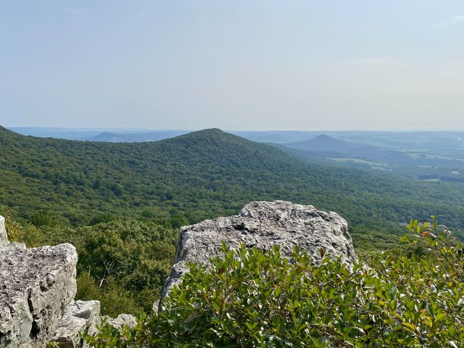
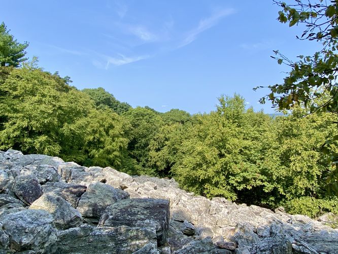
Pulpit Rock Overlook - Mile 2.25
Finally, the trail levels out around mile 2.2 with Pulpit Rock just ahead. Hikers will reach Pulpit Rock around mile 0.25 where you can chill out, enjoying the views of the neighboring mountain peaks and vast panoramic valley views. Pulpit Rock sits on the edge of a steep cliff that has sheer drops of what appeared to be well-over 60-feet in height, so watch your step while exploring the ledge. Pulpit Rock isn't the last stunning view along this hike, so once rested up, you'll want to head on to The Pinnacle next.
Hiking to The Pinnacle - Mile 2.25 to 4.5
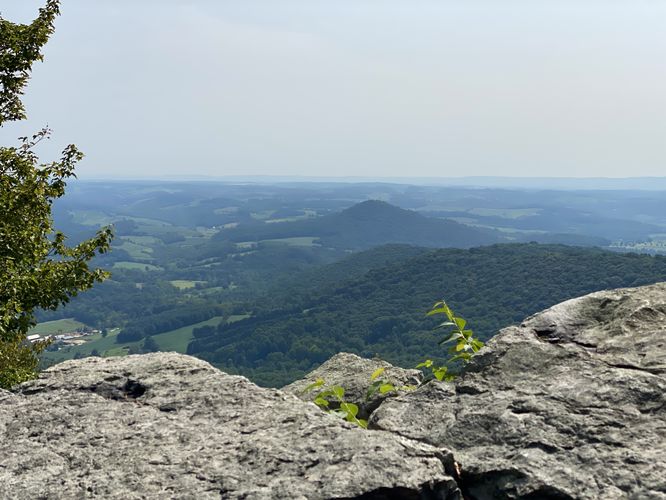
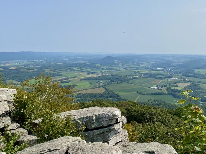
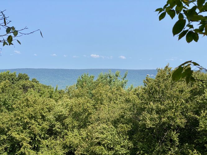
After leaving Pulpit Rock, hikers will head north along the Appalachian Trail as it runs along the mountain's ridge to reach The Pinnacle overlook. Along the way, hikers will find a neat "view" of a boulder field -- likely till dropped by glaciers thousands of years ago -- around mile 2.75. This boulder field is the most-interesting POI along this section of the trail until you approach The Pinnacle. Just before hikers reach the sweeping views of The Pinnacle, around mile 4.4 is a very large stone pile that appears to have been deposited by a glacier long ago and that hikers continue to add to today. Keep-right at the large stone pile to reach The Pinnacle around mile 4.5. The Pinnacle sits at the eastern end of Blue Mountain range at the very tip with a large rock outcropping and rocky cliffs that wrap around the ridge line. From here, you'll find more sweeping valley views and similar vistas of the mountains you saw at Pulpit Rock. Watch out during warm months though as this rocky outcropping is essentially home to Eastern Copperhead and Timber Rattlesnakes.
The Pinnacle to Furnace Creek Trail - Mile 4.5 to 6.25
From The Pinnacle, hikers will follow the Appalachian Trail as it runs along the northern ridge line of Blue Mountain. Just to the west of The Pinnacle is another boulder field with views into the distance toward another AT section near Dan's Pulpit. After passing the boulder field, the trail keeps-right to head west along the north side of the ridge. There's nothing to see or note along this section until you reach the junction with the Furnace Creek Trail at mile 6.25.
Hiking to Hamburg Reservoir - Mile 6.25 to 7.6
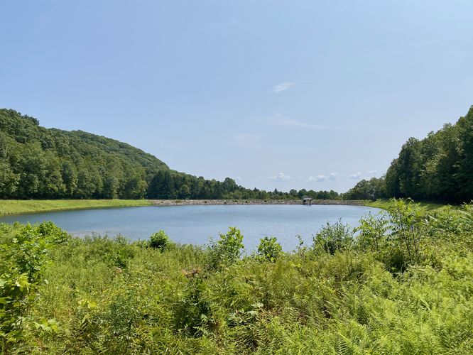
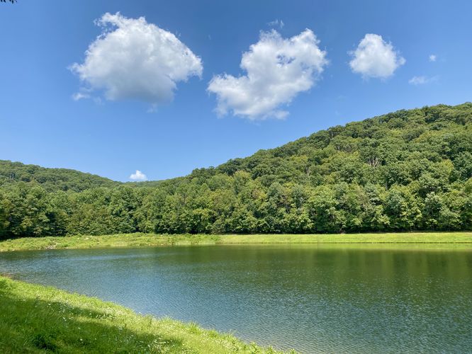
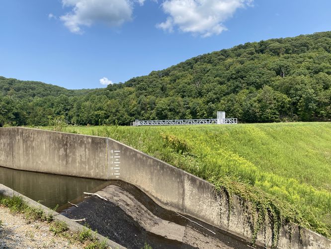
The hike down the Furnace Creek Trail is relatively easy as it leads downhill for most of the hike. Along the way, it passes several creek junctions with large old rhododendrons where you can filter water if need-be (at your own risk). The trail eventually reaches the scenic Hamburg Reservoir around mile 7.6 where you'll find views of the water below Pulpit Rock. The trail wraps around the southwest side of the reservoir to reach a spillway waterfall at mile 8.6.
Hamburg Reservoir to Parking - Mile 7.8 to 8.6
The hike from Hamburg Reservoir to parking is straight forward -- hike straight down the hill and then hike down the crushed gravel stone service road you initially hiked-in on. Complete the loop hike at parking around mile 8.4.
Popularity
This is one of the most popular day hikes in Pennsylvania, so plan on seeing plenty of other hikers especially on weekends. Weekdays are quieter, but still busy during Summer months. During our hike in late August 2024, we showed up around 8:45AM with the parking lot at about 80% full.
Parking
Hikers will find a large parking lot at the coordinates provided, located at the very end of Reservoir Road in Hamburg, PA. The lot is large enough to fit a couple-dozen vehicles as of August 2024.
Pets
Dogs are allowed only if leashed and must be cleaned up after.
Warnings
Venomous Snakes: During warm months (April - October), hikers may spot Timber Rattlesnakes or Eastern Copperheads along the trail. They mostly like to sunbathe on open rocky outcroppings, which comprise both Pulpit Rock and The Pinnacle. The Pinnacle appears to have nearby dens as we encountered two Eastern Copperhead snakes along with on Timber Rattlesnake with her several babies. Last, we found a large Black Rat snake -- all of the snakes we found were at The Pinnacle tucked away under rocks, hiding from day hikers. If you find any rattlers or copperheads, it's best to give them plenty of space.
Steep cliffs: This hike leads to very steep cliffs that have sheer drops of over 60-feet in height. Hike safe while exploring the overlooks.
Trails
Reservoir Road, Appalachian Trail (white blazes), Furnace Creek Trail (blue blazes).
Hike
This hike begins at the main trailhead located at the end of Reservoir Road and follows the crushed stone service road that connects to the Appalachian Trail.
AT to Pulpit Rock - Mile 0.45
At mile 0.45, hikers will take a right-hand turn on the Appalachian Trail (white blazes) to hike up to Pulpit Rock. You'll want to keep-right at the following trail junction to stay on the AT, near mile 0.5. Once on the AT, the hike up to Pulpit Rock is fairly easy at first -- the trail follows a rocky path with a moderate grade for approximately 0.9-miles before the real ascent begins. Around mile 1.45, the hike up to Pulpit Rock becomes a lot harder as the trail begins to follow a much steeper elevation grade. This steep elevation continues until the hiker reaches the summit of Pulpit Rock, but along the way you'll pass boulder fields while traversing a very-rocky path of the Appalachian Trail.
Pulpit Rock Overlook - Mile 2.25
Finally, the trail levels out around mile 2.2 with Pulpit Rock just ahead. Hikers will reach Pulpit Rock around mile 0.25 where you can chill out, enjoying the views of the neighboring mountain peaks and vast panoramic valley views. Pulpit Rock sits on the edge of a steep cliff that has sheer drops of what appeared to be well-over 60-feet in height, so watch your step while exploring the ledge. Pulpit Rock isn't the last stunning view along this hike, so once rested up, you'll want to head on to The Pinnacle next.
Hiking to The Pinnacle - Mile 2.25 to 4.5
After leaving Pulpit Rock, hikers will head north along the Appalachian Trail as it runs along the mountain's ridge to reach The Pinnacle overlook. Along the way, hikers will find a neat "view" of a boulder field -- likely till dropped by glaciers thousands of years ago -- around mile 2.75. This boulder field is the most-interesting POI along this section of the trail until you approach The Pinnacle. Just before hikers reach the sweeping views of The Pinnacle, around mile 4.4 is a very large stone pile that appears to have been deposited by a glacier long ago and that hikers continue to add to today. Keep-right at the large stone pile to reach The Pinnacle around mile 4.5. The Pinnacle sits at the eastern end of Blue Mountain range at the very tip with a large rock outcropping and rocky cliffs that wrap around the ridge line. From here, you'll find more sweeping valley views and similar vistas of the mountains you saw at Pulpit Rock. Watch out during warm months though as this rocky outcropping is essentially home to Eastern Copperhead and Timber Rattlesnakes.
The Pinnacle to Furnace Creek Trail - Mile 4.5 to 6.25
From The Pinnacle, hikers will follow the Appalachian Trail as it runs along the northern ridge line of Blue Mountain. Just to the west of The Pinnacle is another boulder field with views into the distance toward another AT section near Dan's Pulpit. After passing the boulder field, the trail keeps-right to head west along the north side of the ridge. There's nothing to see or note along this section until you reach the junction with the Furnace Creek Trail at mile 6.25.
Hiking to Hamburg Reservoir - Mile 6.25 to 7.6
The hike down the Furnace Creek Trail is relatively easy as it leads downhill for most of the hike. Along the way, it passes several creek junctions with large old rhododendrons where you can filter water if need-be (at your own risk). The trail eventually reaches the scenic Hamburg Reservoir around mile 7.6 where you'll find views of the water below Pulpit Rock. The trail wraps around the southwest side of the reservoir to reach a spillway waterfall at mile 8.6.
Hamburg Reservoir to Parking - Mile 7.8 to 8.6
The hike from Hamburg Reservoir to parking is straight forward -- hike straight down the hill and then hike down the crushed gravel stone service road you initially hiked-in on. Complete the loop hike at parking around mile 8.4.
Popularity
This is one of the most popular day hikes in Pennsylvania, so plan on seeing plenty of other hikers especially on weekends. Weekdays are quieter, but still busy during Summer months. During our hike in late August 2024, we showed up around 8:45AM with the parking lot at about 80% full.
Parking
Hikers will find a large parking lot at the coordinates provided, located at the very end of Reservoir Road in Hamburg, PA. The lot is large enough to fit a couple-dozen vehicles as of August 2024.
Pets
Dogs are allowed only if leashed and must be cleaned up after.
Warnings
Venomous Snakes: During warm months (April - October), hikers may spot Timber Rattlesnakes or Eastern Copperheads along the trail. They mostly like to sunbathe on open rocky outcroppings, which comprise both Pulpit Rock and The Pinnacle. The Pinnacle appears to have nearby dens as we encountered two Eastern Copperhead snakes along with on Timber Rattlesnake with her several babies. Last, we found a large Black Rat snake -- all of the snakes we found were at The Pinnacle tucked away under rocks, hiding from day hikers. If you find any rattlers or copperheads, it's best to give them plenty of space.
Steep cliffs: This hike leads to very steep cliffs that have sheer drops of over 60-feet in height. Hike safe while exploring the overlooks.