Pleasant Mountain via Ledges Trail at Pleasant Mountain Preserve near Denmark, Maine is a moderate 3.8-mile out-and-back hike that leads to southerly ledge views and views of the White Mountains from the summit.
Trails
This hike follows on named trail: Ledges Trail (blue blazes).
Hike
This hike begins at the main trailhead for the Ledges Trail, located at the trailhead coordinates provided on the west side of Mountain Road. The trail starts off by heading uphill to reach an information kiosk. During our hike here in May 2024, we found a handful of hand-carved walking sticks, likely provided by the land trust or some locals. If you use them, please return the hiking sticks for others to use.
Ascent to The Ledges - Mile 0 to 1.1
From the trailhead to mile 0.7, the trail leads up Pleasant Mountain at a moderate grade -- following a rocky path that leads through a buggy forest. The trail has no views, no water sources, or anything to see during this section. It then starts to follow switchbacks between mile 0.7 to 1. These switchbacks are not very difficult, as the trails elevation grade continues following a moderate slope. Finally, around mile 1.1, hikers will reach The Ledges -- where you'll find south-facing views.
The Ledges Views - Mile 1.1 to 1.35
At mile 1.2, hikers will reach the first set of views along The Ledges of Pleasant Mountain. Here, you'll find views of Moose Pond, located at the foot of Pleasant Mountain just below your feet. You can also spot Beaver Pond located to the southwest and surrounding hills and mountains. The views along The Ledges lasts for about a quarter-mile and "end" around mile 1.35. The Ledges also provides views of Pleasant Mountains southern peak, which adorns a radio tower as of May 2024.
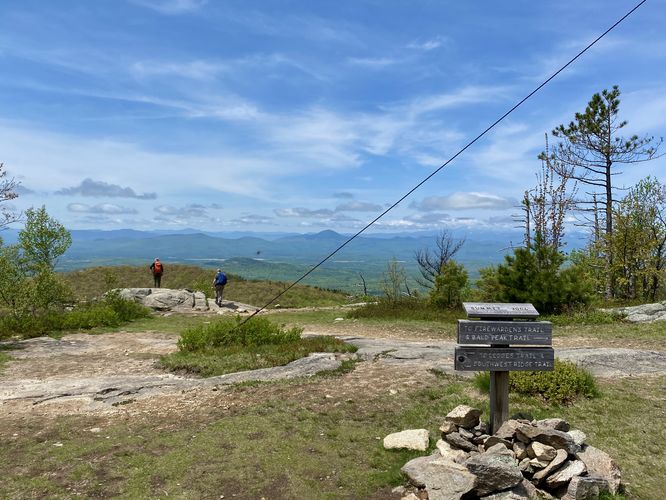
Summit Junction - Mile 1.65
At mile 1.65, hikers will reach a junction with the SW Ridge Trail. Keep-right here to continue onward to Pleasant Mountain's summit.
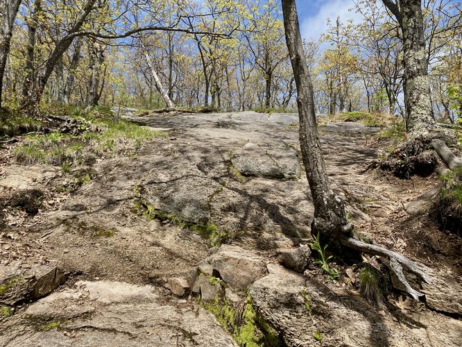
Steep Bedrock / Light Scramble - Mile 1.7
Just beyond the summit sign is a section of very-steep bedrock that hikers will have to lightly scramble up to continue toward the summit. This is less of a scramble and more of just steep bedrock that's somewhat difficult to traverse. If you head the wrong way, you might need to scramble.
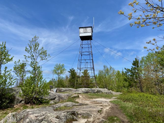
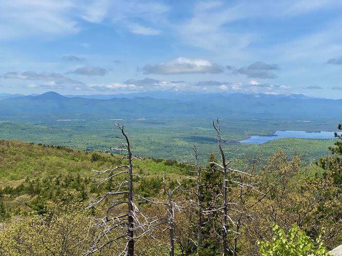
Summit, Lookout Tower, and Views - Mile 1.9
Hikers will continue uphill along the trail before it finally levels out to reach the summit and the old firetower / lookout tower, located around mile 1.87. Here, you'll find a summit sign and a rocky outcropping located to the west where you'll find views. At mile 1.9, you'll reach the viewpoint located at the western section of Pleasant Mountain's summit. The view from the summit includes a massive swath of the White Mountains and lakes or ponds below. During our hike here in late May 2024, we could spot Mt. Washington off in the distance, still covered in a thick layer of snowpack. The views from Pleasant Mountain are some of the best views around, making the hike up to the top well worth it.
Hiking Out - Mile 1.9 to 3.7
The hike out follows the same trail as the hike-in, but obviously is mostly all downhill. The hardest section of the hike out is the steep bedrock traverse, located just below the summit of the mountain. Take this section slow and watch your step. The trail provides a fairly easy hike out as most of the elevation grade is moderate, making for a "softer" descent for the knees. The best part about the hike out is you'll be able to enjoy the view from The Ledges before you descend back into the forest to reach the trailhead.
Parking
Hikers will find a large parking lot at the coordinates provided, located on the east side of Mountain Road. The lot is large enough to fit over a dozen vehicles as of May 2024.
Pets
Dogs are allowed only if leashed and should be cleaned up after.
Warning
Poison ivy: This trail has section of poison ivy that should be avoided. I noted poison ivy around mile 1.45, where the ledges end and the forest hiking begins again. There are likely more section of poison ivy beyond this one patch, so be on the lookout.
Trails
This hike follows on named trail: Ledges Trail (blue blazes).
Hike
This hike begins at the main trailhead for the Ledges Trail, located at the trailhead coordinates provided on the west side of Mountain Road. The trail starts off by heading uphill to reach an information kiosk. During our hike here in May 2024, we found a handful of hand-carved walking sticks, likely provided by the land trust or some locals. If you use them, please return the hiking sticks for others to use.
Ascent to The Ledges - Mile 0 to 1.1
From the trailhead to mile 0.7, the trail leads up Pleasant Mountain at a moderate grade -- following a rocky path that leads through a buggy forest. The trail has no views, no water sources, or anything to see during this section. It then starts to follow switchbacks between mile 0.7 to 1. These switchbacks are not very difficult, as the trails elevation grade continues following a moderate slope. Finally, around mile 1.1, hikers will reach The Ledges -- where you'll find south-facing views.
The Ledges Views - Mile 1.1 to 1.35
At mile 1.2, hikers will reach the first set of views along The Ledges of Pleasant Mountain. Here, you'll find views of Moose Pond, located at the foot of Pleasant Mountain just below your feet. You can also spot Beaver Pond located to the southwest and surrounding hills and mountains. The views along The Ledges lasts for about a quarter-mile and "end" around mile 1.35. The Ledges also provides views of Pleasant Mountains southern peak, which adorns a radio tower as of May 2024.
Summit Junction - Mile 1.65
At mile 1.65, hikers will reach a junction with the SW Ridge Trail. Keep-right here to continue onward to Pleasant Mountain's summit.
Steep Bedrock / Light Scramble - Mile 1.7
Just beyond the summit sign is a section of very-steep bedrock that hikers will have to lightly scramble up to continue toward the summit. This is less of a scramble and more of just steep bedrock that's somewhat difficult to traverse. If you head the wrong way, you might need to scramble.
Summit, Lookout Tower, and Views - Mile 1.9
Hikers will continue uphill along the trail before it finally levels out to reach the summit and the old firetower / lookout tower, located around mile 1.87. Here, you'll find a summit sign and a rocky outcropping located to the west where you'll find views. At mile 1.9, you'll reach the viewpoint located at the western section of Pleasant Mountain's summit. The view from the summit includes a massive swath of the White Mountains and lakes or ponds below. During our hike here in late May 2024, we could spot Mt. Washington off in the distance, still covered in a thick layer of snowpack. The views from Pleasant Mountain are some of the best views around, making the hike up to the top well worth it.
Hiking Out - Mile 1.9 to 3.7
The hike out follows the same trail as the hike-in, but obviously is mostly all downhill. The hardest section of the hike out is the steep bedrock traverse, located just below the summit of the mountain. Take this section slow and watch your step. The trail provides a fairly easy hike out as most of the elevation grade is moderate, making for a "softer" descent for the knees. The best part about the hike out is you'll be able to enjoy the view from The Ledges before you descend back into the forest to reach the trailhead.
Parking
Hikers will find a large parking lot at the coordinates provided, located on the east side of Mountain Road. The lot is large enough to fit over a dozen vehicles as of May 2024.
Pets
Dogs are allowed only if leashed and should be cleaned up after.
Warning
Poison ivy: This trail has section of poison ivy that should be avoided. I noted poison ivy around mile 1.45, where the ledges end and the forest hiking begins again. There are likely more section of poison ivy beyond this one patch, so be on the lookout.