Loading...

🎉 Enjoy a Free 7-Day Supporter Trial and Unlock Exclusive Perks — No Credit Card Required. Learn more.

Pitchoff Mountain and Balanced Rocks Hike

Directions
Map
Pictures
Send to App
Distance:
3.1 Miles / 5.0 km
Type:
Out-and-Back
Difficulty:
Hard
Time to Hike:
1 hour, ~33 minutes
Features:
Surface Type:
Dirt
Park:
Adirondack Park
Town:
North Elba, New York
Directions:
44.219007, -73.887383
Added:
October 18, 2024
Updated:
June 11, 2025
Copy Trail Link Hiking this trail? Send a friend or family member a link to this trail guide for your own safety. Hike at your own risk (disclaimer)
Loading...
Loading...
885'

Total Change
985'

Ascent
973'

Descent

Download the Trail Route for Offline Use

Supporters get exclusive access to download trail routes to the MyHikes app for offline use. Stay prepared on your adventure, even without an internet connection! Become a Supporter today to unlock this feature and hike with confidence.

Send to App

Pitchoff Mountain and Balanced Rocks Hike

The Pitchoff Mountain Trail to Balanced Rocks at Adirondack Park near North Elba, New York is a difficult 3.1-mile out-and-back hike that leads to the beautiful vista point at Balanced Rocks with views that peer into the High Peaks Wilderness.

Trail names: Pitchoff Mountain Trail, Balanced Rocks Trail

Location: Route 73, Sentinel Range Wilderness Area, Keene, NY

Permitted uses: Hiking, Nature Study

Prohibited uses: No motorized equipment

Hours: There are no posted hours.

Fees and Parking: There is no fee to park or use the trails. Parking is very limited but there are three lots near the trailhead, less than a quarter of a mile. We parked in the lot closest to the start of the trail and there was only room for about 4 vehicles. If you park in another lot, use extreme caution while walking on Route 73. Route 73 is heavy with traffic, both fast moving vehicles as well as cyclist training and there is not a sidewalk and a very narrow shoulder.

Pets: Dogs are allowed on a leash.

Accessibility: This hike was not wheelchair accessible.

Hiker amenities: There were two gender neutral portable toilets at the parking lot we parked at. There is no water or trash bins. Carry out what you carry in.

Length and Trail information: CAUTION! The trailhead is diagonal and across from the parking area and is poorly marked. The sign for the entrance to the trail is small and in desperate need of repair. When crossing Route 73, use extreme caution. Traffic can be very dangerous here. The steps leading from Route 73 to the trailhead are in disrepair as well and caution is needed to get up the steps safely. Once you get up the steps and into the woods, there is an information kiosk with a posted map and a hikers registration book. If there is room in the registration book you are encouraged to register as you enter and exit this area.

This hike was done as an out and back hike and is approximately 3.15 miles long. It is a very hard hike with numerous steep ascents and descents. There is a lot of rock scrambling and a very rocky rooted substrate that can be muddy and slippery. The trail is supposed to have red trail blazes, but we also saw yellow ones.

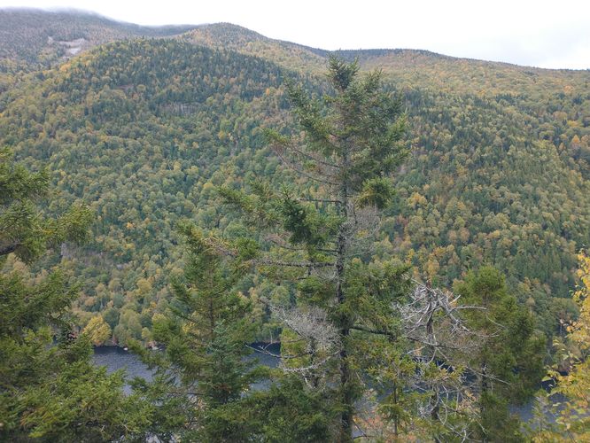
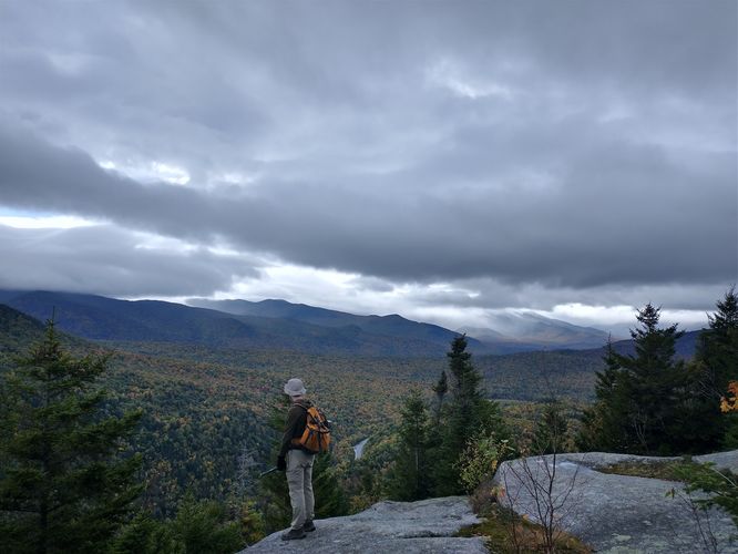
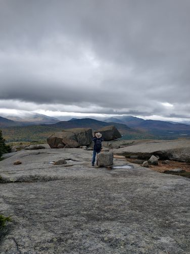
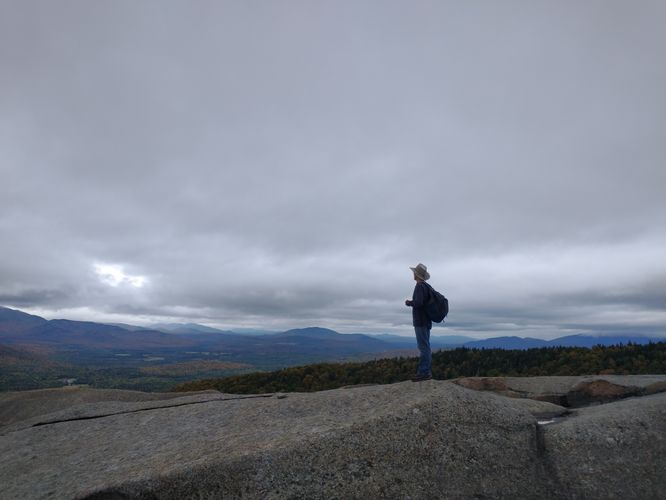
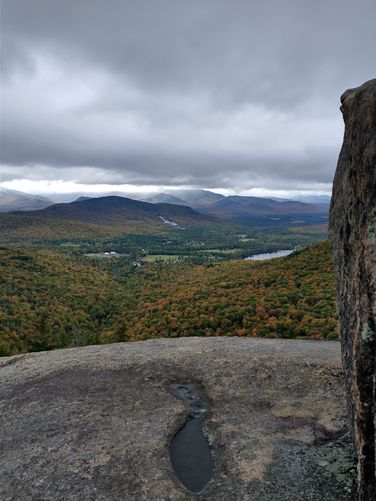
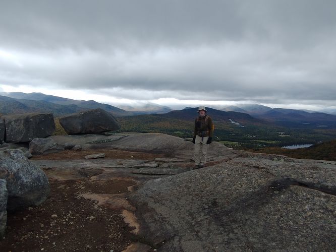
Our goal for this hike was to reach the Balanced Rocks located at about 3000 feet and check out the views. Along the way we were able to see from above both the Upper and Lower Cascade Lakes in the valley below. Before reaching the Balanced Rocks, we came upon an area along the trail with some good sized boulders oddly situated on a wide rocky ledge. I mistook these relatively “small” rocks as THE Balanced Rocks, but that was not the case. The actual Rocks are a bit further down the trail through some low growing trees. Once we cleared the trees we found a massively large exposed rocky plaza with VERY large boulders curiously perched near the edge. The 360 degree views from this plaza are beyond my ability to describe, as I find terms like “breathtaking” and “awe inspiring” insufficient for what we experienced.The plaza is very interesting to explore but be careful while walking around as there are large deep fissures in the rock bed. While we were there we were able to hear, observe and identify a Boreal Chickadee living in the low growing trees around the rocky plaza. After spending some time enjoying the tremendous views of the surrounding landscape and grand vistas, we made our way back to the trail and headed down the steep descent to finish our day of hiking.

Explore 35 trails near North Elba, NY
  1. Parking

    44.219007, -73.887383
  2. Main Trailhead

    44.218992, -73.887498
  3. Glimpse of Cascade Lake below

    44.225351, -73.879297
    Glimpse of Cascade Lake below
  4. Beautiful views

    44.22936, -73.877968
    Beautiful views
  5. THE Balanced Rocks!

    44.229587, -73.878168
    THE Balanced Rocks!
  6. Amazing views from the large rocky plaza

    44.229646, -73.877806
    Amazing views from the large rocky plaza
  7. Views from Balanced Rocks

    44.229466, -73.878364
    Views from Balanced Rocks
  8. The views stretch for miles and miles

    44.229813, -73.878138
    The views stretch for miles and miles
No community routes found. To add your own hike as a Community Route for this Trail guide, leave a Trip Report with an attached GPX file.

Hazards

Ticks - Lyme Disease More Info (CDC)
Poison Ivy/Oak
Rockfalls / Ledges / or Scrambles

Seasons

All

Blaze Color

Red

Blaze Dot

Yellow

Weather Forecast

In North Elba, NY

Explore Hiking Trails

You May Also Like

Colorado's Million Dollar Highway - Plan a day's drive adventure along the iconic Million Dollar Highway in Colorado. Explore the best short trails, roadside stops, waterfalls, vistas, ghost towns, and hot springs within a ~6 hour road trip.
Explore

Colorado's Million Dollar Highway

Plan a day's drive adventure along the iconic Million Dollar Highway in Colorado. Explore the best short trails, roadside stops, waterfalls, vistas, ghost towns, and hot springs within a ~6 hour road trip.

Read
Glacier's Going-to-the-Sun Road - Discover the breathtaking beauty of Glacier National Park along the iconic Going-to-the-Sun Road. From stunning roadside stops to picturesque waterfalls and vistas, this engineering marvel offers endless opportunities for exploration.
Explore

Glacier's Going-to-the-Sun Road

Discover the breathtaking beauty of Glacier National Park along the iconic Going-to-the-Sun Road. From stunning roadside stops to picturesque waterfalls and vistas, this engineering marvel offers endless opportunities for exploration.

Read
New York's Best Waterfalls - Whether you're planning a day hike, roadside stop, or a leisurely short walk, this guide provides hikers, travelers, and locals alike with 63 different locations to over 100 scenic waterfalls to help plan your next adventure!
Explore

New York's Best Waterfalls

Whether you're planning a day hike, roadside stop, or a leisurely short walk, this guide provides hikers, travelers, and locals alike with 63 different locations to over 100 scenic waterfalls to help plan your next adventure!

Read

Before you boogie...

Find our trail guides useful? Consider becoming a Supporter to unlock perks!

MyHikes is an indie platform that makes exploring public trails easier for everyone. The platform has no investors, no ads, and is owned and operated by one person, Dave Miller. Dave has personally mapped and written over 1,800 trail guides on MyHikes for the public to explore. MyHikes has helped millions outdoor enthusiasts plan their next adventure.

But it takes a lot of time 🕦, money 💰, work, and espresso shots ☕ to run MyHikes, including hiking , mapping , writing , and publishing new trails with high-quality (accurate) information... along with software engineering (coding) the platform like building new features, website and mobile app development (iOS and Android), site maintainance . and much much more.

Supporters unlock website and mobile app perks with an annual one-time payment of $25 (you renew) 😎👍. Or you can simply make a Donation of your choice. Otherwise, you can support us by telling your friends about MyHikes - both quick and free 🎉

Admin user profile picture

Dave Miller
MyHikes Founder