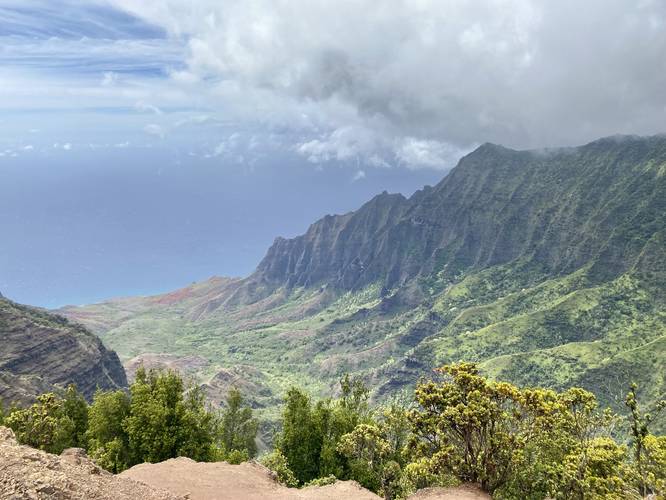
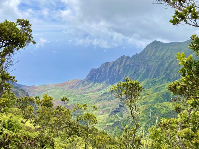
The Pihea Trail Vistas at Koke'e State Park near Waimea, Hawaii (Kauai) is a moderate 0.5-mile out-and-back hike that runs along a scenic mountain ridge, located around 4,200-feet in altitude, and features breathtaking views to the west of the Kalalau Valley and the surrounding mountain range's dramatic ridges in addition to the mountainous plateau highlands of Waimea Canyon to the east.
Hike Description
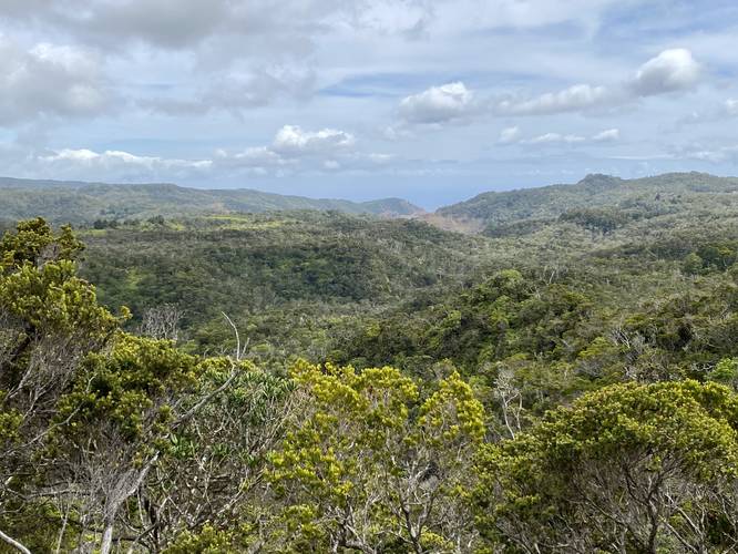
This trail begins at the main parking lot for the Pu'u o Kila Lookout or the Pihea Trail and follows the paved path up a small hill to where the main trailhead for the Pihea Trail starts. Here, the trail changes to a dirt path and immediately begins its moderate descent along a mountain ridge high above the Kalalau Valley. Along the way are plenty of vista points that feature stunning views of the valley below along with the rugged - and waterfall-eroded - mountain ridges with lush rainforests covering the mountain tops. Hikers will also find prehistoric-looking plants like the Hapu'u I'i fern scattered along the trail.
While the Pihea Trail continues on to reach the Pihea Mountain summit, we didn't have enough time to explore the entire trail and simply turned around approximately 0.25-miles down the trail, making for a short 0.5-mile out-and-back hike. Despite this being a very short hike, the views along the trail were worth the visit and thus hikers really don't have to explore very far to get a great view.
Parking & Fees
Visitors will find a large parking lot at the coordinates provided. The lot is large enough to fit several dozen vehicles and overflow parking can be found on the road. There's a vehicle entry fee in addition to individual fees as of June, 2022. By paying for one parking lot, the tickets are valid for all parking lots that require fees for both the Waimea Canyon State Park and Koke'e State Park. Note that for visitors with valid Hawaiian drivers licenses, there are no fees to park or enter.
Warning
Cliffs: Watch your step if you choose to walk near the edge of the mountain ridge as these cliffs are thousands of feet tall.
Respecting the Land
Hawaiian land is considered sacred to native Hawaiians and many locals, so please stay on-trail, take nothing but photos, and leave nothing but footprints. Respect the locals - don't stay for long and have a backup hike planned in case the parking lot is full.
Hike Description
This trail begins at the main parking lot for the Pu'u o Kila Lookout or the Pihea Trail and follows the paved path up a small hill to where the main trailhead for the Pihea Trail starts. Here, the trail changes to a dirt path and immediately begins its moderate descent along a mountain ridge high above the Kalalau Valley. Along the way are plenty of vista points that feature stunning views of the valley below along with the rugged - and waterfall-eroded - mountain ridges with lush rainforests covering the mountain tops. Hikers will also find prehistoric-looking plants like the Hapu'u I'i fern scattered along the trail.
While the Pihea Trail continues on to reach the Pihea Mountain summit, we didn't have enough time to explore the entire trail and simply turned around approximately 0.25-miles down the trail, making for a short 0.5-mile out-and-back hike. Despite this being a very short hike, the views along the trail were worth the visit and thus hikers really don't have to explore very far to get a great view.
Parking & Fees
Visitors will find a large parking lot at the coordinates provided. The lot is large enough to fit several dozen vehicles and overflow parking can be found on the road. There's a vehicle entry fee in addition to individual fees as of June, 2022. By paying for one parking lot, the tickets are valid for all parking lots that require fees for both the Waimea Canyon State Park and Koke'e State Park. Note that for visitors with valid Hawaiian drivers licenses, there are no fees to park or enter.
Warning
Cliffs: Watch your step if you choose to walk near the edge of the mountain ridge as these cliffs are thousands of feet tall.
Respecting the Land
Hawaiian land is considered sacred to native Hawaiians and many locals, so please stay on-trail, take nothing but photos, and leave nothing but footprints. Respect the locals - don't stay for long and have a backup hike planned in case the parking lot is full.