The Perimeter Trail at the Cleveland Lakefront Nature Preserve in Cleveland, Ohio is an easy 1.8-mile loop hike that features views of Lake Erie and the City of Cleveland and is a very-popular bird-watching trail.
Hike Description
This hike begins at the entrance trail to the Cleveland Lakefront Nature Preserve, located at the back corner of the massive parking lot for the park. Hikers will follow this path for 0.1 mile before reaching the actual Perimeter Trail, hence the distance of this hike is 0.2-miles longer than the official length. This recording follows the trail in a counter-clockwise direction, thus all mileage will be based on that direction starting from the parking lot.
Boardwalk - Mile 0.17
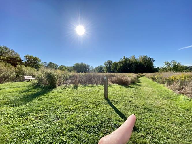
Once at the junction with the Perimeter Trail, hikers will find a very-popular bird-watching spot in the wetlands. After taking a right-hand turn onto the Perimeter Trail, hikers will reach a short boardwalk around mile 0.17 - this is the first true POI along this hike.
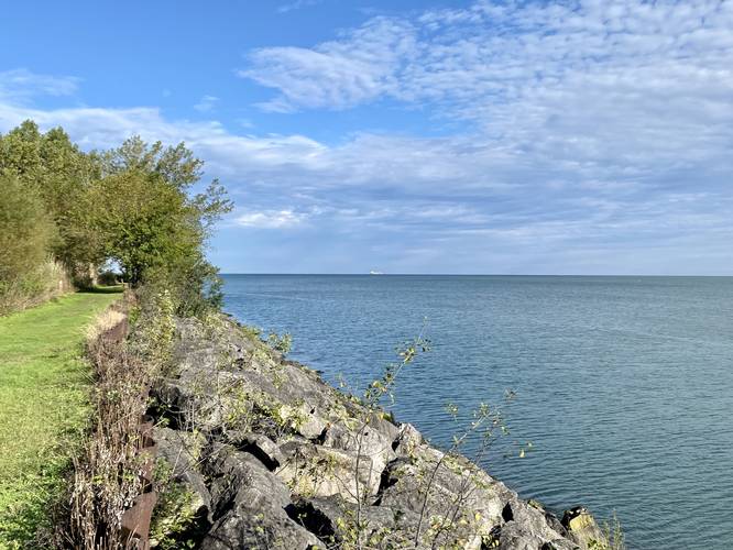
Lake Erie Views - Mile 0.38 & 0.48
After passing the boardwalk, the trail will head downhill to follow a very-flat path as it circles the nature preserve. Once on this flatter, and grassier, section of the trail hikers will reach two vistas of Lake Erie - at mile 0.38 and at mile 0.48. At the mile 0.48 vista, as of September 2022, there's a bench hikers can use to take a short break.
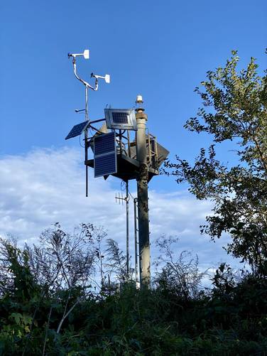
Weather Station - Mile 0.7
At mile 0.7, hikers will pass a metal structure that appears to be a weather station. After passing the weather station, there's not much to see other than the wispy tall grass, some wildflowers, and the potential for bird-watching.
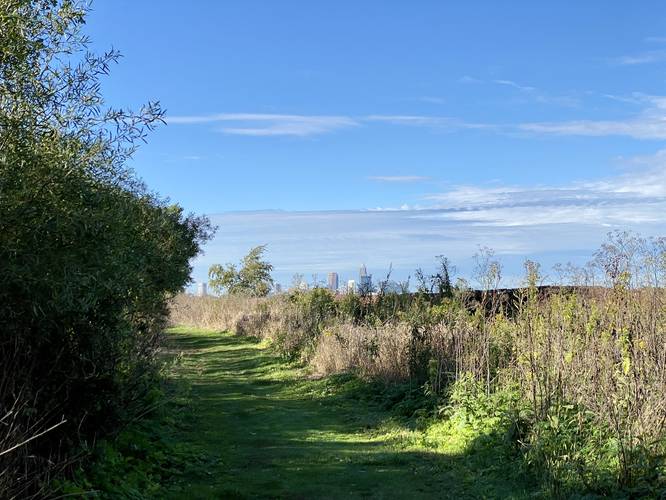
Cleveland Obstructed City View - Mile 0.9
Around mile 0.9, hikers will find the City of Cleveland's tall buildings poking up over the grass during warmer months. During cold months, the city is likely in a more clear view.
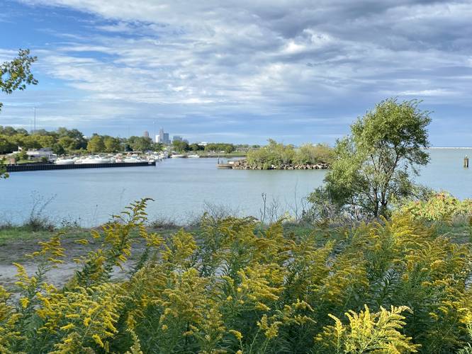
City of Cleveland Overlook - Mile 1.1 to 1.15
At mile 1.1, hikers will take a right-hand turn to follow a short spur trail that leads to the overlook that features a view of the City of Cleveland. This overlook, as of September 2022, is adorned with a large metal fence that's decorated with birds, leaves, butterflies, and feathers that adds scenery to the foreground. To the right of the city view is a very large jetty or breakwater that juts out into Lake Erie to form the Cleveland Harbor. After enjoying the overlook, hikers will follow the spur trail back to the loop, taking a right-hand turn to continue.
Left-Hand Turn - Mile 1.3
Around mile 1.3, hikers will reach a junction - stay left here.
Right-Hand Turn - Mile 1.4
At mile 1.4, hikers will reach a junction with a couple of trails - take a right-hand turn at a 90-degree angle to continue following the Perimeter Trail.
View - Mile 1.45
Around mile 1.45, hikers will pass one last view of Lake Erie's water and the City of Cleveland.
Eventually the Perimeter Trail will make its way back to the official loop trailhead, which is located at the end of the entrance spur trail. Hikers will take a right-hand turn onto the entrance trail to hike back to the parking lot for a 1.8-mile hike.
Pets
Dogs are not allowed on this trail.
Parking
Hikers will find a massive parking lot at the coordinates provided. The lot is large enough to fit many-dozens of vehicles.
Restrooms
There are restrooms located in the south end of the main parking lot.
Water
When the Cleveland Metroparks office is open (was closed in September 2022), they might have a water fountain available for public use.
Hike Description
This hike begins at the entrance trail to the Cleveland Lakefront Nature Preserve, located at the back corner of the massive parking lot for the park. Hikers will follow this path for 0.1 mile before reaching the actual Perimeter Trail, hence the distance of this hike is 0.2-miles longer than the official length. This recording follows the trail in a counter-clockwise direction, thus all mileage will be based on that direction starting from the parking lot.
Boardwalk - Mile 0.17
Once at the junction with the Perimeter Trail, hikers will find a very-popular bird-watching spot in the wetlands. After taking a right-hand turn onto the Perimeter Trail, hikers will reach a short boardwalk around mile 0.17 - this is the first true POI along this hike.
Lake Erie Views - Mile 0.38 & 0.48
After passing the boardwalk, the trail will head downhill to follow a very-flat path as it circles the nature preserve. Once on this flatter, and grassier, section of the trail hikers will reach two vistas of Lake Erie - at mile 0.38 and at mile 0.48. At the mile 0.48 vista, as of September 2022, there's a bench hikers can use to take a short break.
Weather Station - Mile 0.7
At mile 0.7, hikers will pass a metal structure that appears to be a weather station. After passing the weather station, there's not much to see other than the wispy tall grass, some wildflowers, and the potential for bird-watching.
Cleveland Obstructed City View - Mile 0.9
Around mile 0.9, hikers will find the City of Cleveland's tall buildings poking up over the grass during warmer months. During cold months, the city is likely in a more clear view.
City of Cleveland Overlook - Mile 1.1 to 1.15
At mile 1.1, hikers will take a right-hand turn to follow a short spur trail that leads to the overlook that features a view of the City of Cleveland. This overlook, as of September 2022, is adorned with a large metal fence that's decorated with birds, leaves, butterflies, and feathers that adds scenery to the foreground. To the right of the city view is a very large jetty or breakwater that juts out into Lake Erie to form the Cleveland Harbor. After enjoying the overlook, hikers will follow the spur trail back to the loop, taking a right-hand turn to continue.
Left-Hand Turn - Mile 1.3
Around mile 1.3, hikers will reach a junction - stay left here.
Right-Hand Turn - Mile 1.4
At mile 1.4, hikers will reach a junction with a couple of trails - take a right-hand turn at a 90-degree angle to continue following the Perimeter Trail.
View - Mile 1.45
Around mile 1.45, hikers will pass one last view of Lake Erie's water and the City of Cleveland.
Eventually the Perimeter Trail will make its way back to the official loop trailhead, which is located at the end of the entrance spur trail. Hikers will take a right-hand turn onto the entrance trail to hike back to the parking lot for a 1.8-mile hike.
Pets
Dogs are not allowed on this trail.
Parking
Hikers will find a massive parking lot at the coordinates provided. The lot is large enough to fit many-dozens of vehicles.
Restrooms
There are restrooms located in the south end of the main parking lot.
Water
When the Cleveland Metroparks office is open (was closed in September 2022), they might have a water fountain available for public use.