The Peak-A-Boo Vista hike via STS at
Susquehannock State Forest near Galeton, Pennsylvania is a moderate 2.1-mile out-and-back hike that features scenic creeks and leads to a view of Lyman Run Lake from the mountainside view called, Peak-A-Boo Vista.
Hiking to the Peak-A-Boo Vista
This hike begins along the south side of Lyman Run Road, just west of
Lyman Run State Park. To locate the trailhead, simply be on the lookout for a trail sign labeled "
STS" or "
Fish Trail to B & S Trail".
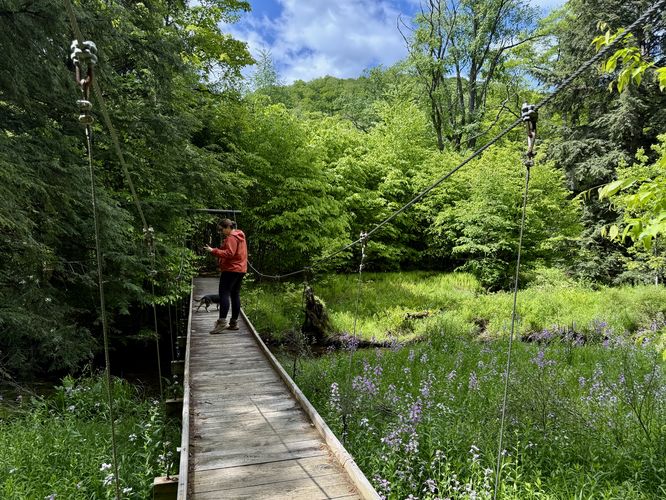
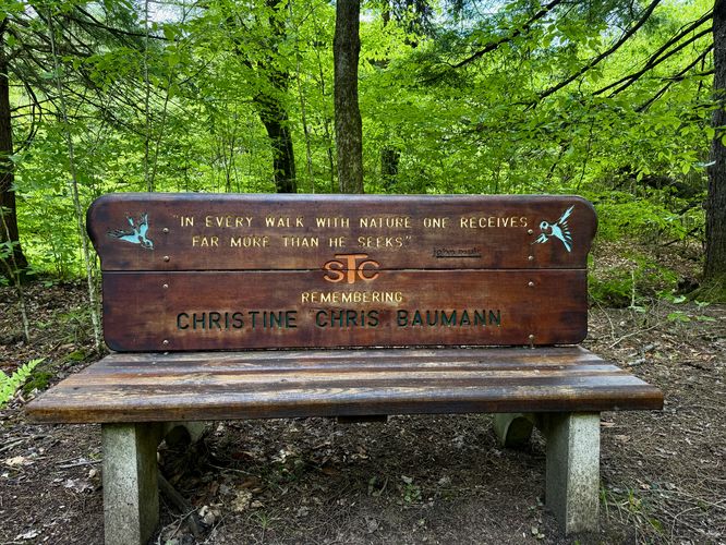
The majority of this hike follows the STS (Susquehannock Trail System) and most hikers will not be disappointed. The STS crew puts a lot of time and effort into maintaining this system of trails and it shows. First, you'll follow a suspension footbridge that spans Lyman Run. This bridge was built in July of 1998 by the Susquehannock Trail Club (STC) with volunteer labor and funding. As you step across the bridge, you may find yourself surrounded by wild flox (wildflowers) as Lyman Run flows under your feet. On our hike here, we found a mallard duck swimming down the creek quacking away, at seemingly nothing. Very scenic. Just beyond the first bridge crossing is a bench in memorial of Christine "Chris" Baumann, crafted by the STC.
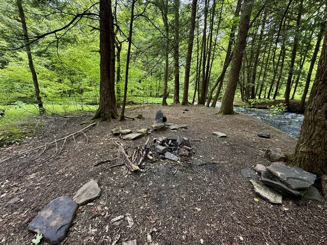
Footbridge Crossing & Campsite - Mile 0.1
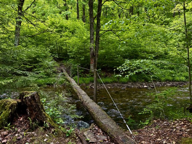
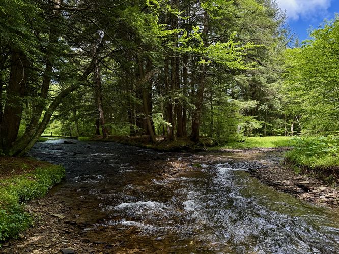
Just 0.1-miles from the trailhead sits a campsite area, located off-trail, and is situated between two creeks -- what appears to be a fork in Lyman Run. This campsite is a beautiful place to setup shop if you're backpacking the entire 90-miles of the STS or if you just need to get away from town to sleep out in the forest for a night. Located on-trail, however, is a very skinny and sometimes slippery footbridge that spans the creek. This footbridge is the crux of the hike -- the rope to hold on to for balance can be wobbly, the tree (used as a bridge) can be slippery when wet, so go slow and take your time. Just beyond the 2nd footbridge sits some nice views of Lyman Run.
Hiking to the ATV Trail - Mile 0.2 to 0.9
After passing the creekside views, the STS heads up the neighboring mountain as it makes its way toward the ATV Trail that runs atop the plateau. The hike up is pretty straight forward. At mile 0.4, keep right at the junction to stay on course. The trail will become skinnier with steep slopes located to the side. Along the way up, if you're hiking during warm months, you'll find an open forest with plenty of ferns covering the forest floor. While the uphill hiking is not easy, it should be considered moderate for most hikers, however, some may find the difficulty harder.
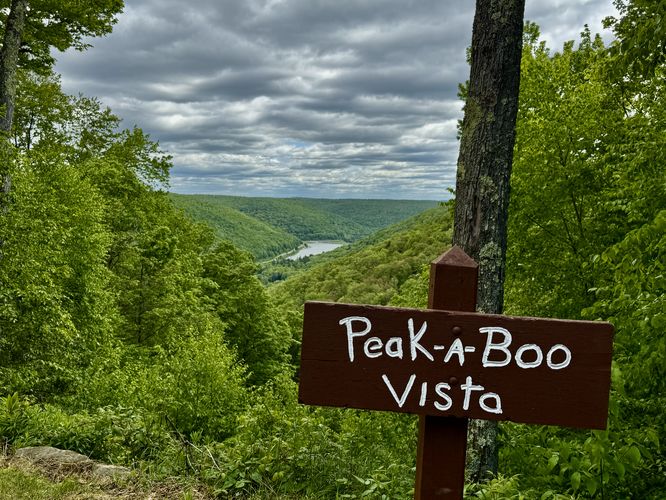
ATV Trail to Peak-A-Boo Vista - Mile 0.9 to 1
Around mile 0.9, hikers will reach the "top" of the mountain's plateau where you'll find a junction with the very-wide ATV Trail -- which basically looks like a dirt road. Take a right-hand turn, leaving the STS behind for now, to follow the ATV Trail north as it leads to Peak-A-Boo Vista. Finally, around mile 1, you'll reach Peak-A-Boo Vista where you'll find views of the mountains that surround Lyman Run Lake in the valley below. During our hike here, we showed up around noon on a weekend to find a group of ATVers already enjoying the view. Depending on what time of day or time of the week you hike this, you might just find yourself all alone at the Peak-A-Boo Vista with beautiful east-facing views of Lyman Run Lake.
Hiking Out - Mile 1 to 2.1
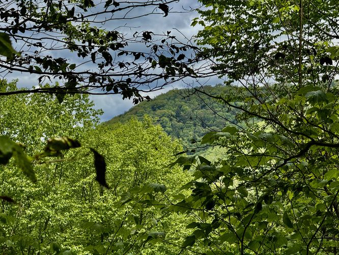
The hike out if simple -- just hike back down the way you came. On your way down, you might notice some obstructed views from the trail, located around mile 1.4, albeit it's just a tiny window of a neighboring mountain slope during warm months. In this route, I stopped at the campsite (near the trailhead), to map that and photograph the camping area and streams. If you skip walking to/from the campsite, you'll likely shave about 0.1-miles off of the hike in total. Enjoy the scenery of Lyman Run and the footbridges on your way out and be sure to be on the lookout for wildlife near or in the creeks, like mallard ducks. The hike wraps up at the trailhead for a moderate-to-difficult 2.1-mile hike.
Parking
Hikers will find a small parking turnout at the coordaintes provided, located on the south side of Lyman Run Road. The turnout is large enough to fit 3 vehicles (max) as of June 2025.
Pets
Dogs are allowed if leashed and must be cleaned up after.
Warning
Timber rattlesnakes: This area is home to the Timber Rattlesnake which can be found roaming the forest floor between the months of April and October each year. Be mindful and if you find any rattlers, give them plenty of space.