The Peachtree Rock and Waterfall Hike at Peachtree Rock Heritage Preserve in Lexington, South Carolina is a moderate 1-mile out-and-back hike that features a 12-foot waterfall and a collapsed rock formation, Peachtree Rock.
Trails
This hike follows one named trail: Blue Trail (blue blazes).
Hike
This hike begins at the main entrance for Peachtree Rock Heritage Preserve located on Peachtree Rock Road near the junction with SC-6. The main trailhead is for the Blue Trail, which leads hikers further into the park. Right off the bat, the Blue Trail heads downhill following a sandy pathway. The initial grade of the trail is steeper than expected, hence the "moderate" difficulty for the hike back to parking; however, the hike-in is easy.
Junction & Rock Ledges - Mile 0.27
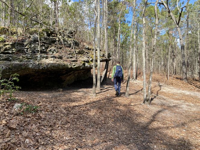
Around mile 0.27, hikers will reach a junction with the Red Trail (red blazes) and a large ledge-like rock outcropping. Here, you'll want to hike northward passing the rock ledge to continue along the Blue Trail to reach Peachtree Rock. This rock ledge, however, is just a small glimpse of the sandstone outcroppings you'll see more of just down the trail.
Peachtree Rock (toppled) - Mile 0.45
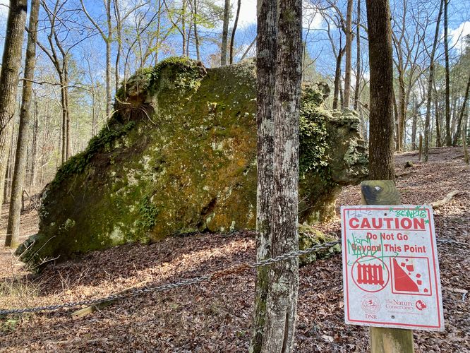
At mile 0.45, hikers will have walked down the hillside to reach a large boulder sitting on the forest floor surrounded by a single linked chain with signs saying "keep back". This rock is the toppled-over Peachtree Rock. Peachtree Rock is a rock formation that used to be balanced upright, shaped like an upside down pyramid. On December 7, 2013, a hiker noticed that the rock had fallen over and is now resting on its side. There's a smaller, similarly-shapred rock formation known as Little Peachtree Rock located in the preserve but further down the trail. If you wish to hike to that rock, please check out the park map for more details on how to get there. These rock formations were created by erosion when the Atlantic waters receded long ago.
12-foot tall Waterfall - Mile 0.5
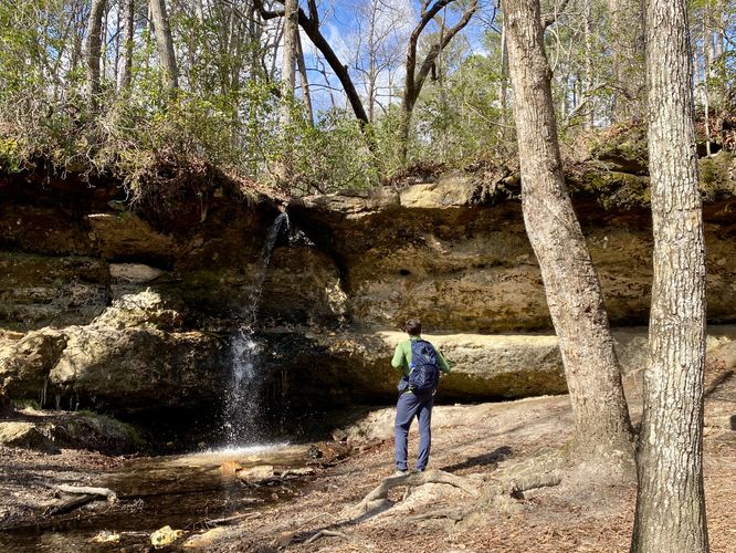
Just beyond Peachtree Rock is a 12-foot tall waterfall that spills down the sandstone bedrock. This waterfall is the only naturally occurring waterfall in the Coastal Plain region of South Carolina. The waterfall's formation is the result of a perched water table that sits higher than the surrounding area. During our hike here in early March 2024, the waterfall was flowing steadily; however, the waterfall's flow may change depending on when and what time of year you visit.
Sandstone Ledges - Mile 0.5
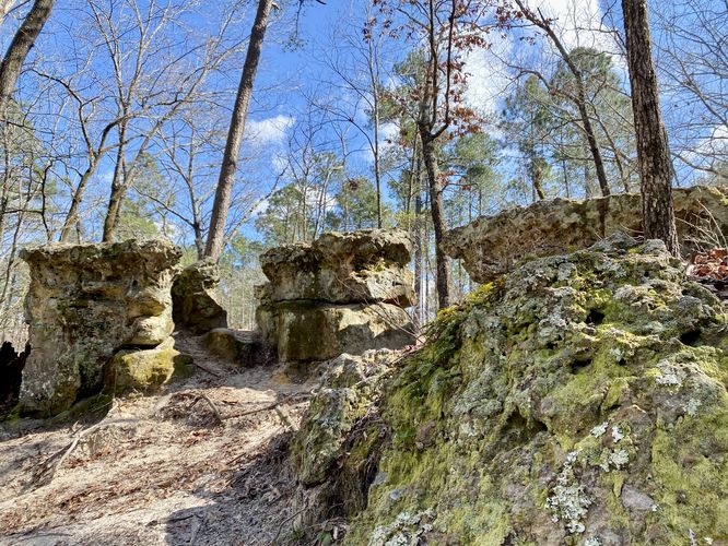
Aside from the 12-foot tall waterfall, at mile 0.5 hikers will also find neat sandstone ledges that separate the higher water table area from the lower "gorge-like" area that Peachtree Rock sits in. One of the more interesting rock formations in these ledges is along the Blue Trail uphill from Peachtree Rock. In the data, it's located around mile 0.42 on the hike in or 0.54 on the hike out. The rock formation are low-lying table-like rocks that have a split between both. In a way, they kind of look like a bottom row of giant's teeth with space between each.
Hiking Out
After exploring the area near mile 0.5, taking in the waterfall, Peachtree Rock, and the surrounding rock formations and ledges, this hike sends you back to parking for a short 1-mile out-and-back. The hike back to parking is simple - keep right at the trail junction with the Red Trail. Take your time up the steep and short climb out of the valley through the pine forest to reach the parking area.
Parking
Hikers will find a small parking lot at the junction of Peachtree Rock Road and SC-6 at the coordinates provided. The lot is large enough to fit a half-dozen vehicles or slightly more as of March 2024.
Pets
Dogs are allowed only if leashed and must be cleaned up after.
Trails
This hike follows one named trail: Blue Trail (blue blazes).
Hike
This hike begins at the main entrance for Peachtree Rock Heritage Preserve located on Peachtree Rock Road near the junction with SC-6. The main trailhead is for the Blue Trail, which leads hikers further into the park. Right off the bat, the Blue Trail heads downhill following a sandy pathway. The initial grade of the trail is steeper than expected, hence the "moderate" difficulty for the hike back to parking; however, the hike-in is easy.
Junction & Rock Ledges - Mile 0.27
Around mile 0.27, hikers will reach a junction with the Red Trail (red blazes) and a large ledge-like rock outcropping. Here, you'll want to hike northward passing the rock ledge to continue along the Blue Trail to reach Peachtree Rock. This rock ledge, however, is just a small glimpse of the sandstone outcroppings you'll see more of just down the trail.
Peachtree Rock (toppled) - Mile 0.45
At mile 0.45, hikers will have walked down the hillside to reach a large boulder sitting on the forest floor surrounded by a single linked chain with signs saying "keep back". This rock is the toppled-over Peachtree Rock. Peachtree Rock is a rock formation that used to be balanced upright, shaped like an upside down pyramid. On December 7, 2013, a hiker noticed that the rock had fallen over and is now resting on its side. There's a smaller, similarly-shapred rock formation known as Little Peachtree Rock located in the preserve but further down the trail. If you wish to hike to that rock, please check out the park map for more details on how to get there. These rock formations were created by erosion when the Atlantic waters receded long ago.
12-foot tall Waterfall - Mile 0.5
Just beyond Peachtree Rock is a 12-foot tall waterfall that spills down the sandstone bedrock. This waterfall is the only naturally occurring waterfall in the Coastal Plain region of South Carolina. The waterfall's formation is the result of a perched water table that sits higher than the surrounding area. During our hike here in early March 2024, the waterfall was flowing steadily; however, the waterfall's flow may change depending on when and what time of year you visit.
Sandstone Ledges - Mile 0.5
Aside from the 12-foot tall waterfall, at mile 0.5 hikers will also find neat sandstone ledges that separate the higher water table area from the lower "gorge-like" area that Peachtree Rock sits in. One of the more interesting rock formations in these ledges is along the Blue Trail uphill from Peachtree Rock. In the data, it's located around mile 0.42 on the hike in or 0.54 on the hike out. The rock formation are low-lying table-like rocks that have a split between both. In a way, they kind of look like a bottom row of giant's teeth with space between each.
Hiking Out
After exploring the area near mile 0.5, taking in the waterfall, Peachtree Rock, and the surrounding rock formations and ledges, this hike sends you back to parking for a short 1-mile out-and-back. The hike back to parking is simple - keep right at the trail junction with the Red Trail. Take your time up the steep and short climb out of the valley through the pine forest to reach the parking area.
Parking
Hikers will find a small parking lot at the junction of Peachtree Rock Road and SC-6 at the coordinates provided. The lot is large enough to fit a half-dozen vehicles or slightly more as of March 2024.
Pets
Dogs are allowed only if leashed and must be cleaned up after.