Otis Falls Trail at Tolland State Forest in Otis, Massachusetts is a moderate 0.2-mile out-and-back hike that leads to two 40-foot waterfalls known as Otis Falls and Otis Tributary Falls.
Hike Description
This hike begins at the very small parking lot along the west side of Tolland Road on the western side of the reservoir. There's an unmarked trail, located behind the "Otis Reservoir Dam" sign that leads into the woods and down the hill to reach the base of Otis Falls. The trail itself is mostly wide, leaf-covered, and leads to a steep hillside. At the steep hill, the trail leads down following rocks and roots to reach the base of both 40-foot waterfalls.
Otis Falls - Mile 0.1
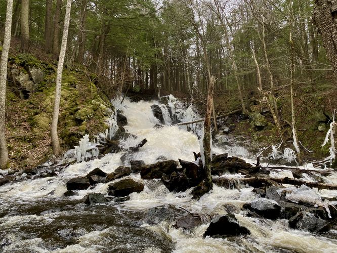
Hikers will find the 40-foot multi-tiered cascade of Otis Falls as it plunges down from the reservoir, located directly ahead in the brook. You won't be able to see the entire waterfall as part of it are cascading down the bedrock around the corner from the viewing area at the base of the falls, but Otis Falls is quite the force to be reckoned with. The strong currents coming out of the Otis Reservoir force their way down Otis Falls and continue onward via the brook. The waterfall is hard to miss, but there's another 40-foot waterfall located to your left.
Otis Tributary Falls - Mile 0.11
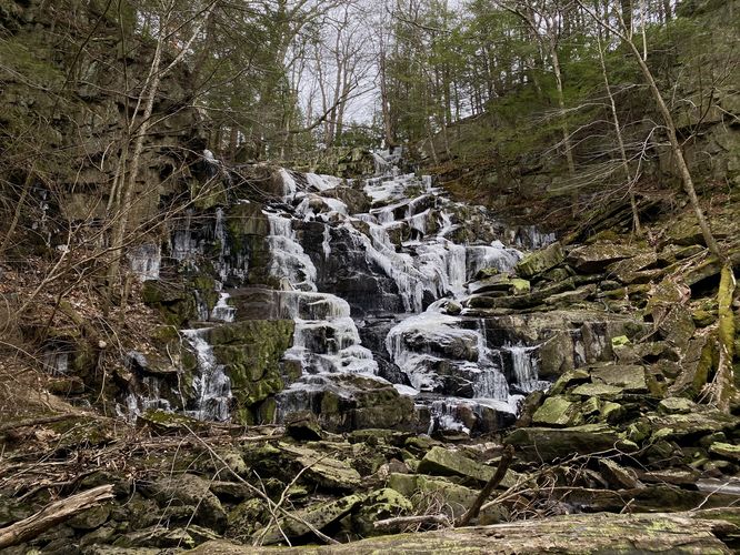
Hike just a bit further, about 100-feet more or so, to get a nice view of Otis Tributary Falls -- another 40-foot waterfall. Note that Otis Tributary Falls has a lot less water, so most of the water that runs out of the reservoir is directed to Otis Falls proper (right-hand side). Otis Tributary Falls is more of a sheer drop and it's possible that this waterfall exists more or less when there's an overflow of water, hence the "trickling" falls instead of the raging cascades of Otis Falls.
After visiting both waterfalls, the hike is done -- head out the way you came in by hiking up the hill and back to parking for a 0.2-mile out-and-back hike.
Parking
Hikers will find a very small parking lot at the coordinates provided, located on the west side of Tolland Road along Otis Reservoir Dam. The parking lot, as of December 2023, is large enough to fit about 3 vehicles max.
Pets
Dogs are allowed only if leashed and must be cleaned up after.
Warning
Slippery rocks: At the base of both waterfalls, the rocks are generally wet from the mist produced by the falls -- during the winter this can be really dangerous without ice spikes. During warmer months, this can be dangerous due to slippery rocks. Watch your step and take your time traversing near the base of the waterfalls.
Hike Description
This hike begins at the very small parking lot along the west side of Tolland Road on the western side of the reservoir. There's an unmarked trail, located behind the "Otis Reservoir Dam" sign that leads into the woods and down the hill to reach the base of Otis Falls. The trail itself is mostly wide, leaf-covered, and leads to a steep hillside. At the steep hill, the trail leads down following rocks and roots to reach the base of both 40-foot waterfalls.
Otis Falls - Mile 0.1
Hikers will find the 40-foot multi-tiered cascade of Otis Falls as it plunges down from the reservoir, located directly ahead in the brook. You won't be able to see the entire waterfall as part of it are cascading down the bedrock around the corner from the viewing area at the base of the falls, but Otis Falls is quite the force to be reckoned with. The strong currents coming out of the Otis Reservoir force their way down Otis Falls and continue onward via the brook. The waterfall is hard to miss, but there's another 40-foot waterfall located to your left.
Otis Tributary Falls - Mile 0.11
Hike just a bit further, about 100-feet more or so, to get a nice view of Otis Tributary Falls -- another 40-foot waterfall. Note that Otis Tributary Falls has a lot less water, so most of the water that runs out of the reservoir is directed to Otis Falls proper (right-hand side). Otis Tributary Falls is more of a sheer drop and it's possible that this waterfall exists more or less when there's an overflow of water, hence the "trickling" falls instead of the raging cascades of Otis Falls.
After visiting both waterfalls, the hike is done -- head out the way you came in by hiking up the hill and back to parking for a 0.2-mile out-and-back hike.
Parking
Hikers will find a very small parking lot at the coordinates provided, located on the west side of Tolland Road along Otis Reservoir Dam. The parking lot, as of December 2023, is large enough to fit about 3 vehicles max.
Pets
Dogs are allowed only if leashed and must be cleaned up after.
Warning
Slippery rocks: At the base of both waterfalls, the rocks are generally wet from the mist produced by the falls -- during the winter this can be really dangerous without ice spikes. During warmer months, this can be dangerous due to slippery rocks. Watch your step and take your time traversing near the base of the waterfalls.