The Olowalu Trail in Olowalu, Hawaii (Maui) is an easy 2.8-mile out-and-back paved trail that features views of the West Maui Mountains, an old abandoned reservoir, Molokini Crater, and the islands of Kaho'olawe and Lanai.
Hike Description
This hike begins at a very tiny parking turnout located next to the trailhead on Luawai Street in Olowalu. Hikers have a choice of which way to walk first - heading west includes views of the West Maui Mountains and the abandoned reservoir, while heading east connects to an upscale neighborhood located at the top of Luawai Street. This track heads west first, then backtracks east, and then back to parking
Olowalu Trail (West) - Mile 0 to 1
If following this GPS track, hikers will head west first to follow this as an out-and-back for 1-mile total. The path, heading west, is almost entirely flat which makes for easy walking. It also has the best views of the West Maui Mountains. As of February 2023, this trail is seemingly still under-construction, so walkers and hikers may find dirt mounds on the side of the trail with white plastic pipes sticking out - it appears as though these mounds are meant for growing new plants and trees that may not grow here otherwise. The pipes are used for irrigation to water the plants.
Views of Kilea (Cinder Cone)
You may also notice the cinder cone known as Kilea at the foreground of the West Maui Mountains - this is actually a spot hikers can checkout too, known as the Olowalu Petroglyphs.
Abandoned Reservoir - Mile 0.4 to 0.5
Soon, the hiker will cross a dirt path that intersects with the paved trail and just beyond here is the old abandoned reservoir. This reservoir is quite large and the trail follows the top of it for about 0.1-miles before reaching the Olowalu Stream. Hikers may notice the large cut-out in the reservoir located on the northeast corner, which was either deliberately destroyed or may have been an accident in the past; however, there's no signage or historical information about this reservoir.
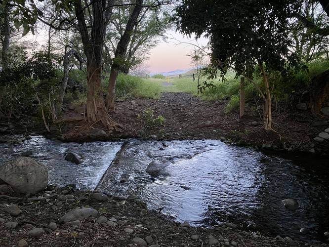
Olowalu Stream - Mile 0.5 (turn-around)
At mile 0.5, hikers will reach a stream crossing with the Olowalu Stream. Since this was our last morning on Maui, and were not prepared to get our feet wet, we turned back here.
Olowalu Trail (East) - Mile 1 to 2.75
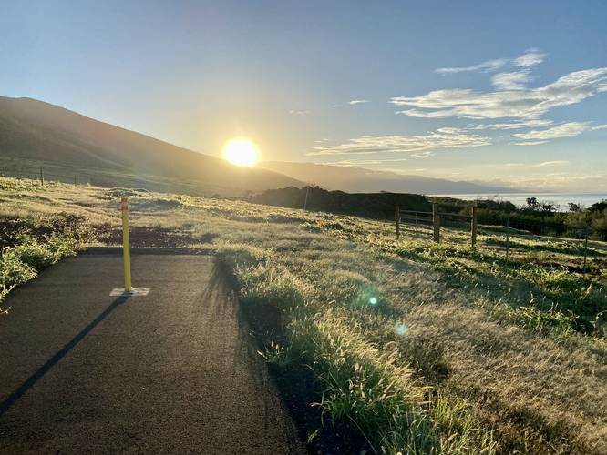
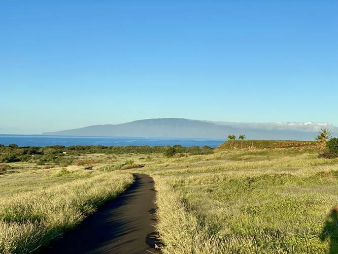
After checking out the west side of the Olowalu Trail, hikers may want to explore the eastern half too. Albeit, the western side is more interesting, the eastern half provides views and an uphill section for exercise. The paved path heads uphill at a gradual pace before reaching a trail junction. At the trail junction, this recording heads uphill to reach the upscale neighborhood along Luawai Street first. At Luawai Street, there's another parking turnout for the trail, but it's small too - no more than 3 vehicles can fit. Note that the pavement ends in the last 0.1-miles headed uphill to Luawai Street. On the way down from Luawai Street, hikers will get beautiful views of the Pacific Ocean wrapped around Maui and Olowalu's shoreline, Haleakala's slopes to the east, Molokini Crater, and the islands of Kaho'olawe and Lanai in the distance. Once back at the trail junction, hikers may want to head east to checkout the last section of the trail - it follows a mostly-flat grade as it heads east passing large flat-topped stone piles before reaching a dead-end after just 0.2-miles. As someone without any prior history or knowledge to the area, these massive flat-topped stone piles are intriguing, but I have no idea what they are or why they exist.
Hiking Out
The obvious choice, after reaching the final dead-end, is to hike back to parking. If following this route, the hike back to parking is very easy and either mostly-flat or mostly downhill.
Pets
Dogs are allowed if leashed and they must be cleaned-up after.
Biking
It's assumed that biking this trail is permitted.
Parking
Hikers will find two parking turnouts for this hike - both of which are very very small. The coordinates provided will bring you to the "lowland" parking lot, which is further away from the Luawai Street's upscale community. You can also park uphill along Luawai Street at 20.817494, -156.610008, which provides another very small parking turnout. Each parking turnout is large enough to fit less than 3 vehicles. Please do not overcrowd.
Accessibility
This trail follows a paved path for almost the entirety of the GPS track provided. Note that this trail is almost accessible - the parking lots are not universally accessible as the main parking turnout is on grass and the other parking turnout is located on rocks. If parking at the main turnout, it's "easier" to get onto pavement of the road and the trail itself. The uphill parking turnout connects to a rock path that eventually connects to pavement, thus is not accessible. The western side of the trail is mostly flat while the eastern side provides an uphill ascent that might not be fully accessible.
Official Trail Name
Please note that this trail name is made-up (Olowalu Trail). As of February 2023, this paved trail seemed to be entirely brand new. Neither trailhead had any signage with information or even a trail name. It's hard to tell what's going on with this public trail, but my assumption is that it was built for these newer housing developments in Olowalu and thus serves as a public space to connect these communities.
Mostly Locals
As of February 2023, this trail seemed to be only used by locals because tourists don't really know it exists (yet). We got some funny looks from local walkers on this trail and you may too, if this spot never becomes very popular. As of February 2023, this might be the only trail on Maui that 99.9% of tourists don't know about. Sorry locals, I had to map it :)
Respecting the Land
Hawaiian land is considered sacred to native Hawaiians and many locals, so please stay on-trail, take nothing but photos, and leave nothing but footprints. Respect the locals - don't stay for long and have a backup hike planned in case the parking lot is full.
Hike Description
This hike begins at a very tiny parking turnout located next to the trailhead on Luawai Street in Olowalu. Hikers have a choice of which way to walk first - heading west includes views of the West Maui Mountains and the abandoned reservoir, while heading east connects to an upscale neighborhood located at the top of Luawai Street. This track heads west first, then backtracks east, and then back to parking
Olowalu Trail (West) - Mile 0 to 1
If following this GPS track, hikers will head west first to follow this as an out-and-back for 1-mile total. The path, heading west, is almost entirely flat which makes for easy walking. It also has the best views of the West Maui Mountains. As of February 2023, this trail is seemingly still under-construction, so walkers and hikers may find dirt mounds on the side of the trail with white plastic pipes sticking out - it appears as though these mounds are meant for growing new plants and trees that may not grow here otherwise. The pipes are used for irrigation to water the plants.
Views of Kilea (Cinder Cone)
You may also notice the cinder cone known as Kilea at the foreground of the West Maui Mountains - this is actually a spot hikers can checkout too, known as the Olowalu Petroglyphs.
Abandoned Reservoir - Mile 0.4 to 0.5
Soon, the hiker will cross a dirt path that intersects with the paved trail and just beyond here is the old abandoned reservoir. This reservoir is quite large and the trail follows the top of it for about 0.1-miles before reaching the Olowalu Stream. Hikers may notice the large cut-out in the reservoir located on the northeast corner, which was either deliberately destroyed or may have been an accident in the past; however, there's no signage or historical information about this reservoir.
Olowalu Stream - Mile 0.5 (turn-around)
At mile 0.5, hikers will reach a stream crossing with the Olowalu Stream. Since this was our last morning on Maui, and were not prepared to get our feet wet, we turned back here.
Olowalu Trail (East) - Mile 1 to 2.75
After checking out the west side of the Olowalu Trail, hikers may want to explore the eastern half too. Albeit, the western side is more interesting, the eastern half provides views and an uphill section for exercise. The paved path heads uphill at a gradual pace before reaching a trail junction. At the trail junction, this recording heads uphill to reach the upscale neighborhood along Luawai Street first. At Luawai Street, there's another parking turnout for the trail, but it's small too - no more than 3 vehicles can fit. Note that the pavement ends in the last 0.1-miles headed uphill to Luawai Street. On the way down from Luawai Street, hikers will get beautiful views of the Pacific Ocean wrapped around Maui and Olowalu's shoreline, Haleakala's slopes to the east, Molokini Crater, and the islands of Kaho'olawe and Lanai in the distance. Once back at the trail junction, hikers may want to head east to checkout the last section of the trail - it follows a mostly-flat grade as it heads east passing large flat-topped stone piles before reaching a dead-end after just 0.2-miles. As someone without any prior history or knowledge to the area, these massive flat-topped stone piles are intriguing, but I have no idea what they are or why they exist.
Hiking Out
The obvious choice, after reaching the final dead-end, is to hike back to parking. If following this route, the hike back to parking is very easy and either mostly-flat or mostly downhill.
Pets
Dogs are allowed if leashed and they must be cleaned-up after.
Biking
It's assumed that biking this trail is permitted.
Parking
Hikers will find two parking turnouts for this hike - both of which are very very small. The coordinates provided will bring you to the "lowland" parking lot, which is further away from the Luawai Street's upscale community. You can also park uphill along Luawai Street at 20.817494, -156.610008, which provides another very small parking turnout. Each parking turnout is large enough to fit less than 3 vehicles. Please do not overcrowd.
Accessibility
This trail follows a paved path for almost the entirety of the GPS track provided. Note that this trail is almost accessible - the parking lots are not universally accessible as the main parking turnout is on grass and the other parking turnout is located on rocks. If parking at the main turnout, it's "easier" to get onto pavement of the road and the trail itself. The uphill parking turnout connects to a rock path that eventually connects to pavement, thus is not accessible. The western side of the trail is mostly flat while the eastern side provides an uphill ascent that might not be fully accessible.
Official Trail Name
Please note that this trail name is made-up (Olowalu Trail). As of February 2023, this paved trail seemed to be entirely brand new. Neither trailhead had any signage with information or even a trail name. It's hard to tell what's going on with this public trail, but my assumption is that it was built for these newer housing developments in Olowalu and thus serves as a public space to connect these communities.
Mostly Locals
As of February 2023, this trail seemed to be only used by locals because tourists don't really know it exists (yet). We got some funny looks from local walkers on this trail and you may too, if this spot never becomes very popular. As of February 2023, this might be the only trail on Maui that 99.9% of tourists don't know about. Sorry locals, I had to map it :)
Respecting the Land
Hawaiian land is considered sacred to native Hawaiians and many locals, so please stay on-trail, take nothing but photos, and leave nothing but footprints. Respect the locals - don't stay for long and have a backup hike planned in case the parking lot is full.