The Okolehau Trail at the Hanalei National Wildlife Refuge in Princeville, Hawaii (Kauai) is a moderate 1.4-mile out-and-back trail that leads up to a bench with a vista point at a power line crossing and features views of Hanalei Bay, the massive mountains that surround the bay, and taro fields in the valley below. This is the only publicly-accessible trail in the wildlife refuge as of June, 2022.
Hike Description
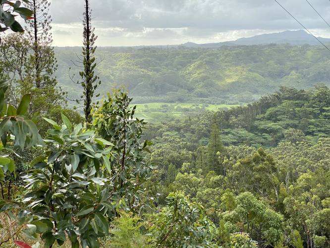
This trail begin just south of the main parking lot - where a small footbridge crosses a stream that runs adjacent to the road. After or during a rainfall, this bridge can be a bit slippery. The trail begins by gradually heading uphill within the first 0.1-miles, but then the steeper elevation grade kicks in just before mile 0.15. When the trail is wet, the clay-like substrate (hardened Kauai red dirt) becomes extremely slick, so there's black netting placed along the trail to help hikers from slipping and falling. Trekking poles help a ton on this trail as well. Note that some parts of this trail are a bit overgrown, but the jungle-like feel of this hike is well-worth the experience if you're not used to seeing the tropical plants that inhabit the Hanalei Bay area.
Hard Climb - Mile 0.4
Around mile 0.4, the trail follows an even steeper elevation grade, but still has plenty of patches of black netting to help keep your footing. Note that a slip on this grade could easily mean that you end up at the bottom of the hill, 120-feet downhill, so taking your time - using trekking poles - and walking on the netting will keep you safe.
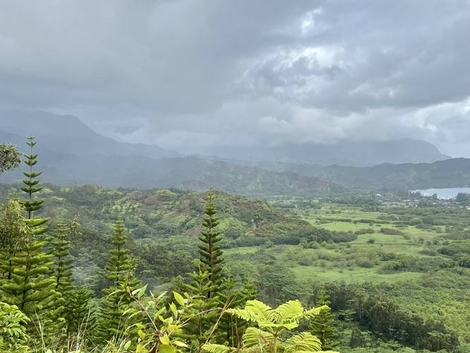
Hanalei Bay Vista - Mile 0.7
Finally, the trail will hit a switchback as it changes to a more gradual ascent. Just beyond the switchback, the hike ends at the bench located just underneath the power lines. There are views to both sides of the mountain since the benches are located on a mountain ridge. To the west, hikers get stunning views of Hanalei Bay and the mountains that surround them. On a clear day, it's likely possible that hikers get a view of the massive 2,500+ foot waterfall that cascades down one of these giants; however, I was not lucky enough to have the weather cooperate on the day I hiked this. Below are taro fields which are managed by the wildlife refuge and potentially leased out to local farmers. To the east, hikers will find a nice view of the surrounding hills towards Princeville, Hawaii.
Hiking Out
As mentioned, the slick wet substrate of the trail can make this hike a bit dangerous. Take your time heading downhill and always walk on the black netting on the trail to ensure your feet have less of a chance to slip. The hike down is not terrible and is generally a bit faster than the uphill climb, especially with trekking poles.
Parking
Hikers will find a parking lot by the coordinates provided. It's large enough to fit about 10 cars or less. There's another turnout across from the trailhead that can fit a few more vehicles.
Pets
Dogs are allowed if leashed at all times.
Warnings
Slippery trail: As stated several times, after or during a rainfall, this trail becomes very slippery. Its best to bring trekking poles and always walk on the black netting placed on the trail, which helps with traction.
Respecting the Land
Hawaiian land is considered sacred to native Hawaiians and many locals, so please stay on-trail, take nothing but photos, and leave nothing but footprints. Respect the locals - don't stay for long and have a backup hike planned in case the parking lot is full.
Hike Description
This trail begin just south of the main parking lot - where a small footbridge crosses a stream that runs adjacent to the road. After or during a rainfall, this bridge can be a bit slippery. The trail begins by gradually heading uphill within the first 0.1-miles, but then the steeper elevation grade kicks in just before mile 0.15. When the trail is wet, the clay-like substrate (hardened Kauai red dirt) becomes extremely slick, so there's black netting placed along the trail to help hikers from slipping and falling. Trekking poles help a ton on this trail as well. Note that some parts of this trail are a bit overgrown, but the jungle-like feel of this hike is well-worth the experience if you're not used to seeing the tropical plants that inhabit the Hanalei Bay area.
Hard Climb - Mile 0.4
Around mile 0.4, the trail follows an even steeper elevation grade, but still has plenty of patches of black netting to help keep your footing. Note that a slip on this grade could easily mean that you end up at the bottom of the hill, 120-feet downhill, so taking your time - using trekking poles - and walking on the netting will keep you safe.
Hanalei Bay Vista - Mile 0.7
Finally, the trail will hit a switchback as it changes to a more gradual ascent. Just beyond the switchback, the hike ends at the bench located just underneath the power lines. There are views to both sides of the mountain since the benches are located on a mountain ridge. To the west, hikers get stunning views of Hanalei Bay and the mountains that surround them. On a clear day, it's likely possible that hikers get a view of the massive 2,500+ foot waterfall that cascades down one of these giants; however, I was not lucky enough to have the weather cooperate on the day I hiked this. Below are taro fields which are managed by the wildlife refuge and potentially leased out to local farmers. To the east, hikers will find a nice view of the surrounding hills towards Princeville, Hawaii.
Hiking Out
As mentioned, the slick wet substrate of the trail can make this hike a bit dangerous. Take your time heading downhill and always walk on the black netting on the trail to ensure your feet have less of a chance to slip. The hike down is not terrible and is generally a bit faster than the uphill climb, especially with trekking poles.
Parking
Hikers will find a parking lot by the coordinates provided. It's large enough to fit about 10 cars or less. There's another turnout across from the trailhead that can fit a few more vehicles.
Pets
Dogs are allowed if leashed at all times.
Warnings
Slippery trail: As stated several times, after or during a rainfall, this trail becomes very slippery. Its best to bring trekking poles and always walk on the black netting placed on the trail, which helps with traction.
Respecting the Land
Hawaiian land is considered sacred to native Hawaiians and many locals, so please stay on-trail, take nothing but photos, and leave nothing but footprints. Respect the locals - don't stay for long and have a backup hike planned in case the parking lot is full.