The Ohlone Wilderness Trail at the Ohlone Regional Wilderness is a strenuous 28 mile one-way trail that features stunning mountain vistas and connects the Del Valle Regional Park to Mission Peak Regional Preserve in Fremont, CA.
The trail passes through the Ohlone Regional Wilderness and Sunol Regional Wilderness, as well a large section of land that's owned by the San Francisco Water District. Please note that in the water district section, you are not allowed to leave the trail.
The trail is 28 miles in length, which does not include detours to campsites, vista points, stopping points, or hiking to the top of Mission Peak. The area serves plenty of hiking options, so day hikers can plan a multitude of out-and-back day trips throughout the trails in this area and are not stuck to hiking 28 miles one-way.
Trip Details
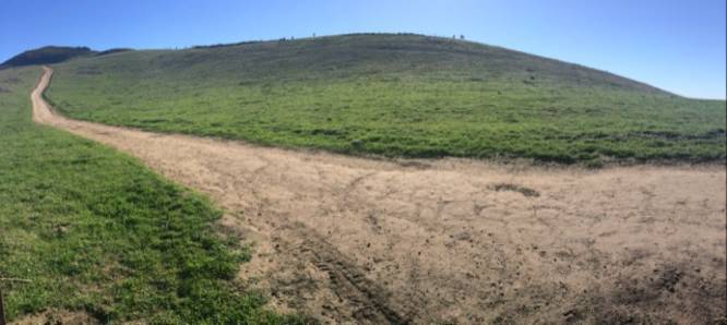
From the parking lot, the trail ascends a very steep hill that continues on for almost 1-mile before reaching the Ohlone Wilderness Trail sign. At this point, hikers must sign-in and have their permits, including day hikers. From here, the hike continues onward for another 1,000 feet or so toward Boyd Camp and the Rocky Ridge Trail.
After reaching the top of the first main climb, the trail descends toward Williams Gultch. From Williams Gultch onward is yet another massive climb, the Big Burn, with 1,200 feet of elevation gain in less than 2 miles. At the top of the Big Burn is Shlieper Rock - a large rocky outcropping overlooking neighboring hills.
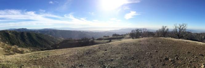
After reaching Shlieper Rock, the trail undulates a couple-hundred feet as it winds its way over to Rose Peak. Hikers can take in the vistas from Rose Peak before heading downhill toward Maggie's Half Acre - another campsite available for backpackers which lies less than a half-mile from Rose Peak summit. Maggie's Half Acre campsite generally has potable water for refilling.
The trail from Maggie's Half Acre heading toward the Sunol Regional Wilderness is mostly all downhill for about 9 miles. Along the hike down, hikers will pass through forests and rolling hills that usually have grazing cows.
Just before the trail continues back uphill toward Mission Peak is the Sunol Visitor Center - another stop where hikers can refill their water bottles.
On the way to Mission Peak is where hikers will pass through the San Francisco Water District section of the trail which is fairly large. You may not leave the trail in this section, as stated previously.
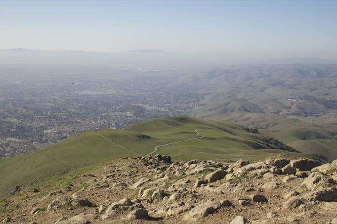
Once you reach Mission peak, hikers get plenty of stunning vistas of the surrounding area. Mission Peak is another very popular day hike for hikers coming in from the west along the Hidden Valley Trail.
From Mission Peak, the hike out is just over 4 miles down a very steep mountain trail and out to the end of this 28 mile trek.
Permit and Fee Requirements
A permit is required for both day hikers and thru-hiking backpackers. There is also a small fee collected ranging between $2 and $4 per person. More information can be found at https://www.ebparks.org/parks/ohlone/
Backpacking and Camping
A separate camping reservation is required for backpackers and campers. Camping is only allowed at designated campsites. Camping reservations are required to be placed two days before the start of your trip by calling the Reservations Department at 1-888-327-2757, option 2 (8:30am-4:00pm PST, M-F). More information can be found at https://www.ebparks.org/parks/ohlone
Shuttle Services
A shuttle or other transportation arrangement is required to thru-hike the entire 28 miles.
Parking
Hikers will find a very large parking lot at the coordinates provided, but be warned that this lot is often very busy. Sometimes hikers will need to park outside of the lot along the roadside.
Warning
Mountain lion, while seldom seen, are known to inhabit these woods. It's best to not hike along and make noise while you hike to scare away any unseen mountain lions. If hiking with children, keep them close, as mountain lions are attracted more to children than anything.
For more trip details, check out this NorCal Hiker blogpost.
The trail passes through the Ohlone Regional Wilderness and Sunol Regional Wilderness, as well a large section of land that's owned by the San Francisco Water District. Please note that in the water district section, you are not allowed to leave the trail.
The trail is 28 miles in length, which does not include detours to campsites, vista points, stopping points, or hiking to the top of Mission Peak. The area serves plenty of hiking options, so day hikers can plan a multitude of out-and-back day trips throughout the trails in this area and are not stuck to hiking 28 miles one-way.
Trip Details
From the parking lot, the trail ascends a very steep hill that continues on for almost 1-mile before reaching the Ohlone Wilderness Trail sign. At this point, hikers must sign-in and have their permits, including day hikers. From here, the hike continues onward for another 1,000 feet or so toward Boyd Camp and the Rocky Ridge Trail.
After reaching the top of the first main climb, the trail descends toward Williams Gultch. From Williams Gultch onward is yet another massive climb, the Big Burn, with 1,200 feet of elevation gain in less than 2 miles. At the top of the Big Burn is Shlieper Rock - a large rocky outcropping overlooking neighboring hills.
After reaching Shlieper Rock, the trail undulates a couple-hundred feet as it winds its way over to Rose Peak. Hikers can take in the vistas from Rose Peak before heading downhill toward Maggie's Half Acre - another campsite available for backpackers which lies less than a half-mile from Rose Peak summit. Maggie's Half Acre campsite generally has potable water for refilling.
The trail from Maggie's Half Acre heading toward the Sunol Regional Wilderness is mostly all downhill for about 9 miles. Along the hike down, hikers will pass through forests and rolling hills that usually have grazing cows.
Just before the trail continues back uphill toward Mission Peak is the Sunol Visitor Center - another stop where hikers can refill their water bottles.
On the way to Mission Peak is where hikers will pass through the San Francisco Water District section of the trail which is fairly large. You may not leave the trail in this section, as stated previously.
Once you reach Mission peak, hikers get plenty of stunning vistas of the surrounding area. Mission Peak is another very popular day hike for hikers coming in from the west along the Hidden Valley Trail.
From Mission Peak, the hike out is just over 4 miles down a very steep mountain trail and out to the end of this 28 mile trek.
Permit and Fee Requirements
A permit is required for both day hikers and thru-hiking backpackers. There is also a small fee collected ranging between $2 and $4 per person. More information can be found at https://www.ebparks.org/parks/ohlone/
Backpacking and Camping
A separate camping reservation is required for backpackers and campers. Camping is only allowed at designated campsites. Camping reservations are required to be placed two days before the start of your trip by calling the Reservations Department at 1-888-327-2757, option 2 (8:30am-4:00pm PST, M-F). More information can be found at https://www.ebparks.org/parks/ohlone
Shuttle Services
A shuttle or other transportation arrangement is required to thru-hike the entire 28 miles.
Parking
Hikers will find a very large parking lot at the coordinates provided, but be warned that this lot is often very busy. Sometimes hikers will need to park outside of the lot along the roadside.
Warning
Mountain lion, while seldom seen, are known to inhabit these woods. It's best to not hike along and make noise while you hike to scare away any unseen mountain lions. If hiking with children, keep them close, as mountain lions are attracted more to children than anything.
For more trip details, check out this NorCal Hiker blogpost.