The Nu'alolo Trail (Nualolo Trail) at Koke'e State Park near Wainiha, Hawaii (Kauai) is a difficult 8-mile out-and-back hike that leads to the breathtaking Lolo Vista which sits along Hawaii's most-stunning coastline, the Na Pali coast.
Hike Description
This hike begins at the small parking lot for the Nu'alolo Trail at the coordinates provided and immediately heads in along a short switchback before the trail makes an initial ascent up to a small hill. At the top of this small hill, as of June 2022, is an information sign about fences in the forest - which is a sign of good forestry by the Koke'e State Park to keep certain wildlife in or out from the mountain ridge. Hikers will spot this fence further into the hike, it's obvious and a boring sight, but you may see hunters come and go through the small gate on your hike.
After the initial small hill ascent, the trail is mostly all downhill until the hiker reaches the Lolo Vista. Along the way, hikers will find several different plant species along this trail's ever-changing ecosystem as you meander your way from the cooler high-elevation Hawaiian jungle-like forest down to the warmer scrubland-like lower growing elevation plant species closer to the vista.
Old Growth Tree, Blackberry Bushes - Mile 0.5 - 0.7
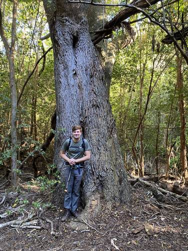
Around mile 0.5, hikers may notice a very large old growth tree on the right-hand side of the trail (heading west). Just around this area is an abundance of blackberry bushes that hikers can snack on on their way.
Jungle-like Forest - Mile 0.8
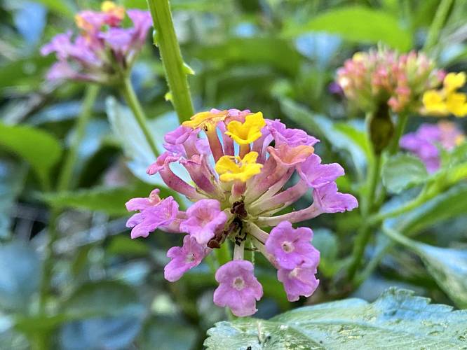
Around mile 0.8, hikers will enter a more jungle-like Hawaiian forest which is filled with Kahili Ginger and lantana wildflowers in addition to shampoo ginger plants ('Awapuhi). The Kahili Ginger plants are the most prominant of the wildflowers in this section since they stand out with large cylindrical displays of large but thin yellow wildflowers which have orange-red stamens. The lantana wildflower also add a beautiful touch to this part of the forest since these large perennials are essentially trees with ever-blooming pink, orange, and yellow bunches of wildflowers.
Hillside View - Mile 2.1
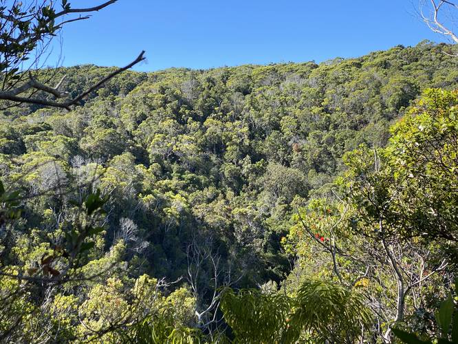
Around mile 2.1, hikers will reach the first view along the trail, but it's simply a view of the neighboring mountain's hillside. While not worthy of much attention, this vista serves well as a "halfway point" marker for hikers. This is also where the trail becomes worse in terms of terrain and elevation loss (or gain on the returning ascent).
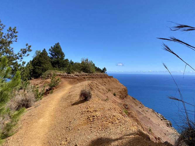
Ocean Views & Steeper Descent Begins - Mile 2.45 to 2.6
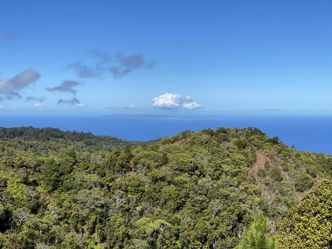
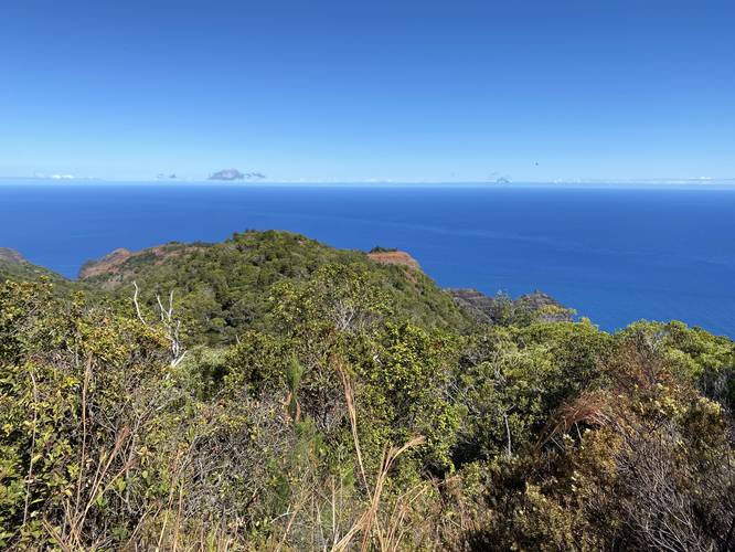
Once the hiker reaches mile 2.45, they'll encounter the first views that actually include the ocean; however, the views aren't very spectacular just yet. Hikers will be able to see the island of Ni'ihau and the Lehua Crater from this vista though which is a welcomed sight. Upon our hike we assumed we'd have a nice breeze at this point, but none really existed here (or anywhere else for that matter). Here is also where the steeper descents begin with a few of them along the way down.
Nu'alolo Cliff Trail Junction - Mile 3
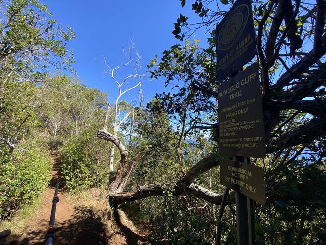
Around mile 3, hikers will reach the junction with the Nu'alolo Cliff Trail. To stay on the easier safer route, stay left at this junction; however, if you take that trail and then stay left again, you will reach the Nu'alolo Trail once more for a longer route.
Steep Descent - Mile 3.3 to 3.6
The hardest section of this hike lies between miles 3.3 and 3.6 where the trail, in certain areas, drops down about 3-feet vertical every foot forward or so. If you can't picture that, picture a steep muddy rutted-out trail with weird footholds and roots that descends for 250 vertical feet. We used trekking poles on this hike and they came in handy for this and every steep grade we encountered.
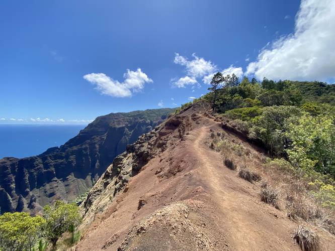
Volcanic Ridge Crossing, 1,800-foot vertical Cliff Ledges - Mile 3.65 to 3.85
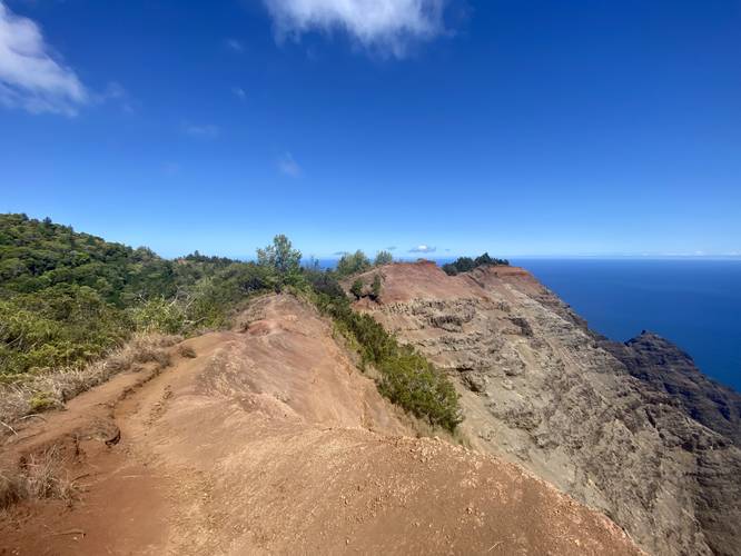
The most dangerous sections of the trail begin around mile 6.65, starting with what I've nicknamed the "Volcanic Ridge Crossing". For about 200-feet the hiker must traverse a very skinny, sketchy, and super steep mountain ridge that has no handrails to keep you safe. To the northern side is a 1,800-foot vertical drop and on the southern side, the lesser of the two evils, is a 50-foot (or maybe less) vertical drop which could still cause series injury or death regardless. The Volcanic Ridge Crossing is not for those who are afraid of heights, like myself, but for some hikes you just have to overcome those fears to enjoy something different - here, we trekked on and crossed the ridge. Just beyond the ridge, the trail traverses alongside the cliffs once again which feels terrifying but hikers can keep about 4 or 5-feet away from the ledge at all times which helps. The entire horrifying cliff hiking lasts for a total of about 0.2-miles before the trail reaches a gradual flatter area just before the Lolo Vista.
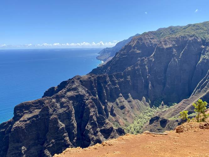
Lolo Vista - Mile 4
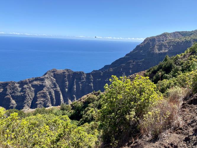
At mile 4, hikers will reach the "end" of the trail which is marked by a metal guardrail - this is the Lolo Vista. The Lolo Vista features breathtaking views of the Na Pali coast, which is probably one of the most scenic coastlines in all of the Hawaiian islands. The sheer 1,800-foot vertical mountain ridges, with their ever-eroding volcanic rock will forever be changing - causing even more dramatic landscape changes as time goes on. For now, hikers can appreciate the jagged mountain ridge lines, the beautiful blue and turquoise waters of the Pacific Ocean, tourist boats circling extremely-remote northwestern Kauai beaches, and tourist helicopters flying spectators overhead on a constant schedule. The Lolo Vista, if you can physically make the journey, is one of the most spectacular oceanside vistas, likely in the world.
Hiking out and Mountain Ascents - Miles 4 - 8
Between miles 4 and 6, hikers will be faced with a rough mountain ascent. Despite not "summitting" any real mountain along this hike, the elevation gain is worthy of a mountain ascent due to the sheer steepness of sections of this trail along with the fact that you are in fact hiking back up an ancient volcanic mountain. Some of these steep sections of trail require you to hold on to roots to help pull yourself up. Trekking poles certainly help a lot in these situations as well. Between miles 6 and 8, the trail is certainly easier to hike, but still follows a mostly-moderate ascent. The last push is around mile 7.45 as the trail becomes a bit more steep as it ascends the last hill before the short descent to parking at mile 8.
Warnings
Sheer cliff ledges: This hike follows several areas that sit adjacent to massive cliff ledges that plunge over 1,800 vertical feet to the valley below. Due to this, hikers must take extreme cautions, and hike slowly, as you make your way along these mountain ridges and cliff edges.
Sun exposure and heat exhaustion: About half of this hike, closer to the end of trail, dips in and out of large sunny spots with some shady areas in between. From mile 3.6 to mile 4, there's virtually no protection from the shade except for one patch of trees near the Lolo Vista. Hikers should come prepared with sunscreen and a hat to protect yourself from the UV index 11 sun rays. Additionally, wearing clothing like shorts (unlike what we did) also helps reduce the chance of overheating or getting heat stroke. Temperatures certainly reach the high 70s in these mountains and it becomes hotter as you lose elevation heading toward the Lolo Vista.
Elevation gain and difficulty: The Koke'e State Park's website listed this hike as ~1,500 vertical feet of elevation gain; however, this estimation does not take into the consideration of the trail's undulating total elevation gain which is much closer to 2,300 vertical feet. While, for the experienced hiker, this much elevation gain is not horrendous over 8-miles, it's still challenging due to the heat and terrain. For those who are not experienced hikers, it's recommended to find another hike - you do not want to succumb to heat exhaustion or need to be rescued here.
Lack of cell service: For most of this hike, there's no cell service - especially closest to the Lolo Vista. If you're in dire need for help and cannot hike back from the Lolo Vista, hikers can create signs in the dirt near the vista to try and alert the tourist helicopters that fly overhead on constant schedules during daylight hours. By writing "SOS" in the dirt in large letters, a tourist helicopter is bound to see it and report it to authorities to get you help. Do not do this unless you're in dire need of actually being rescued and cannot hike back - all fines by the state are applied to anyone who needs to be rescued and this can cost thousands of dollars and person hours.
Lack of breeze: When we hiked this in late June 2022, we assumed there would be a ton of air movement on this trail, especially closer to the ocean at the end of the hike. What we found was the opposite - there was very little air movement in the form of any breezes. This made it feel suffocating when being roasted by the sun in the exposed areas, especially at the Lolo Vista and hiking back from the vista. It's worth noting because most hikers wouldn't guess this is the case; however, it's possible the time of year caused for a lack of breeze on this part of the island.
No water: This hike has no streams to filter water from. On this hike, it took us ~5 hours to complete, and we only carried 1 full liter of water per person. This was a mistake, we should have been carrying at least 1.5 liters per person due to the lack of shade, UV index 11 sun rays, and lack of water along this hike.
Pets
Dogs are not allowed on this trail; however, we did find some kids hunting for wild pigs with their dog upon our hike here. Laws might be different for hunters, but the general public should not walk their dogs on this trail due to state park rules and regulations.
Parking
Hikers will find a small parking lot at the coordinates provided. The lot is large enough to fit less than 10 vehicles.
Popularity
This hike is not very popular, compared to other hikes on Kauai and thus is lightly trafficked. Please note that not all hikes are for everyone and this one should certainly weed out the general public. 8-miles is a long distance and ~2,300-feet of vertical elevation gain in total should really not be attempted by the general public when hiking on vacation unless you and your hiking partner(s) are in very good physical condition and can handle this type of hiking.
Respecting the Land
Hawaiian land is considered sacred to native Hawaiians and many locals, so please stay on-trail, take nothing but photos, and leave nothing but footprints. Respect the locals - don't stay for long and have a backup hike planned in case the parking lot is full.
Hike Description
This hike begins at the small parking lot for the Nu'alolo Trail at the coordinates provided and immediately heads in along a short switchback before the trail makes an initial ascent up to a small hill. At the top of this small hill, as of June 2022, is an information sign about fences in the forest - which is a sign of good forestry by the Koke'e State Park to keep certain wildlife in or out from the mountain ridge. Hikers will spot this fence further into the hike, it's obvious and a boring sight, but you may see hunters come and go through the small gate on your hike.
After the initial small hill ascent, the trail is mostly all downhill until the hiker reaches the Lolo Vista. Along the way, hikers will find several different plant species along this trail's ever-changing ecosystem as you meander your way from the cooler high-elevation Hawaiian jungle-like forest down to the warmer scrubland-like lower growing elevation plant species closer to the vista.
Old Growth Tree, Blackberry Bushes - Mile 0.5 - 0.7
Around mile 0.5, hikers may notice a very large old growth tree on the right-hand side of the trail (heading west). Just around this area is an abundance of blackberry bushes that hikers can snack on on their way.
Jungle-like Forest - Mile 0.8
Around mile 0.8, hikers will enter a more jungle-like Hawaiian forest which is filled with Kahili Ginger and lantana wildflowers in addition to shampoo ginger plants ('Awapuhi). The Kahili Ginger plants are the most prominant of the wildflowers in this section since they stand out with large cylindrical displays of large but thin yellow wildflowers which have orange-red stamens. The lantana wildflower also add a beautiful touch to this part of the forest since these large perennials are essentially trees with ever-blooming pink, orange, and yellow bunches of wildflowers.
Hillside View - Mile 2.1
Around mile 2.1, hikers will reach the first view along the trail, but it's simply a view of the neighboring mountain's hillside. While not worthy of much attention, this vista serves well as a "halfway point" marker for hikers. This is also where the trail becomes worse in terms of terrain and elevation loss (or gain on the returning ascent).
Ocean Views & Steeper Descent Begins - Mile 2.45 to 2.6
Once the hiker reaches mile 2.45, they'll encounter the first views that actually include the ocean; however, the views aren't very spectacular just yet. Hikers will be able to see the island of Ni'ihau and the Lehua Crater from this vista though which is a welcomed sight. Upon our hike we assumed we'd have a nice breeze at this point, but none really existed here (or anywhere else for that matter). Here is also where the steeper descents begin with a few of them along the way down.
Nu'alolo Cliff Trail Junction - Mile 3
Around mile 3, hikers will reach the junction with the Nu'alolo Cliff Trail. To stay on the easier safer route, stay left at this junction; however, if you take that trail and then stay left again, you will reach the Nu'alolo Trail once more for a longer route.
Steep Descent - Mile 3.3 to 3.6
The hardest section of this hike lies between miles 3.3 and 3.6 where the trail, in certain areas, drops down about 3-feet vertical every foot forward or so. If you can't picture that, picture a steep muddy rutted-out trail with weird footholds and roots that descends for 250 vertical feet. We used trekking poles on this hike and they came in handy for this and every steep grade we encountered.
Volcanic Ridge Crossing, 1,800-foot vertical Cliff Ledges - Mile 3.65 to 3.85
The most dangerous sections of the trail begin around mile 6.65, starting with what I've nicknamed the "Volcanic Ridge Crossing". For about 200-feet the hiker must traverse a very skinny, sketchy, and super steep mountain ridge that has no handrails to keep you safe. To the northern side is a 1,800-foot vertical drop and on the southern side, the lesser of the two evils, is a 50-foot (or maybe less) vertical drop which could still cause series injury or death regardless. The Volcanic Ridge Crossing is not for those who are afraid of heights, like myself, but for some hikes you just have to overcome those fears to enjoy something different - here, we trekked on and crossed the ridge. Just beyond the ridge, the trail traverses alongside the cliffs once again which feels terrifying but hikers can keep about 4 or 5-feet away from the ledge at all times which helps. The entire horrifying cliff hiking lasts for a total of about 0.2-miles before the trail reaches a gradual flatter area just before the Lolo Vista.
Lolo Vista - Mile 4
At mile 4, hikers will reach the "end" of the trail which is marked by a metal guardrail - this is the Lolo Vista. The Lolo Vista features breathtaking views of the Na Pali coast, which is probably one of the most scenic coastlines in all of the Hawaiian islands. The sheer 1,800-foot vertical mountain ridges, with their ever-eroding volcanic rock will forever be changing - causing even more dramatic landscape changes as time goes on. For now, hikers can appreciate the jagged mountain ridge lines, the beautiful blue and turquoise waters of the Pacific Ocean, tourist boats circling extremely-remote northwestern Kauai beaches, and tourist helicopters flying spectators overhead on a constant schedule. The Lolo Vista, if you can physically make the journey, is one of the most spectacular oceanside vistas, likely in the world.
Hiking out and Mountain Ascents - Miles 4 - 8
Between miles 4 and 6, hikers will be faced with a rough mountain ascent. Despite not "summitting" any real mountain along this hike, the elevation gain is worthy of a mountain ascent due to the sheer steepness of sections of this trail along with the fact that you are in fact hiking back up an ancient volcanic mountain. Some of these steep sections of trail require you to hold on to roots to help pull yourself up. Trekking poles certainly help a lot in these situations as well. Between miles 6 and 8, the trail is certainly easier to hike, but still follows a mostly-moderate ascent. The last push is around mile 7.45 as the trail becomes a bit more steep as it ascends the last hill before the short descent to parking at mile 8.
Warnings
Sheer cliff ledges: This hike follows several areas that sit adjacent to massive cliff ledges that plunge over 1,800 vertical feet to the valley below. Due to this, hikers must take extreme cautions, and hike slowly, as you make your way along these mountain ridges and cliff edges.
Sun exposure and heat exhaustion: About half of this hike, closer to the end of trail, dips in and out of large sunny spots with some shady areas in between. From mile 3.6 to mile 4, there's virtually no protection from the shade except for one patch of trees near the Lolo Vista. Hikers should come prepared with sunscreen and a hat to protect yourself from the UV index 11 sun rays. Additionally, wearing clothing like shorts (unlike what we did) also helps reduce the chance of overheating or getting heat stroke. Temperatures certainly reach the high 70s in these mountains and it becomes hotter as you lose elevation heading toward the Lolo Vista.
Elevation gain and difficulty: The Koke'e State Park's website listed this hike as ~1,500 vertical feet of elevation gain; however, this estimation does not take into the consideration of the trail's undulating total elevation gain which is much closer to 2,300 vertical feet. While, for the experienced hiker, this much elevation gain is not horrendous over 8-miles, it's still challenging due to the heat and terrain. For those who are not experienced hikers, it's recommended to find another hike - you do not want to succumb to heat exhaustion or need to be rescued here.
Lack of cell service: For most of this hike, there's no cell service - especially closest to the Lolo Vista. If you're in dire need for help and cannot hike back from the Lolo Vista, hikers can create signs in the dirt near the vista to try and alert the tourist helicopters that fly overhead on constant schedules during daylight hours. By writing "SOS" in the dirt in large letters, a tourist helicopter is bound to see it and report it to authorities to get you help. Do not do this unless you're in dire need of actually being rescued and cannot hike back - all fines by the state are applied to anyone who needs to be rescued and this can cost thousands of dollars and person hours.
Lack of breeze: When we hiked this in late June 2022, we assumed there would be a ton of air movement on this trail, especially closer to the ocean at the end of the hike. What we found was the opposite - there was very little air movement in the form of any breezes. This made it feel suffocating when being roasted by the sun in the exposed areas, especially at the Lolo Vista and hiking back from the vista. It's worth noting because most hikers wouldn't guess this is the case; however, it's possible the time of year caused for a lack of breeze on this part of the island.
No water: This hike has no streams to filter water from. On this hike, it took us ~5 hours to complete, and we only carried 1 full liter of water per person. This was a mistake, we should have been carrying at least 1.5 liters per person due to the lack of shade, UV index 11 sun rays, and lack of water along this hike.
Pets
Dogs are not allowed on this trail; however, we did find some kids hunting for wild pigs with their dog upon our hike here. Laws might be different for hunters, but the general public should not walk their dogs on this trail due to state park rules and regulations.
Parking
Hikers will find a small parking lot at the coordinates provided. The lot is large enough to fit less than 10 vehicles.
Popularity
This hike is not very popular, compared to other hikes on Kauai and thus is lightly trafficked. Please note that not all hikes are for everyone and this one should certainly weed out the general public. 8-miles is a long distance and ~2,300-feet of vertical elevation gain in total should really not be attempted by the general public when hiking on vacation unless you and your hiking partner(s) are in very good physical condition and can handle this type of hiking.
Respecting the Land
Hawaiian land is considered sacred to native Hawaiians and many locals, so please stay on-trail, take nothing but photos, and leave nothing but footprints. Respect the locals - don't stay for long and have a backup hike planned in case the parking lot is full.