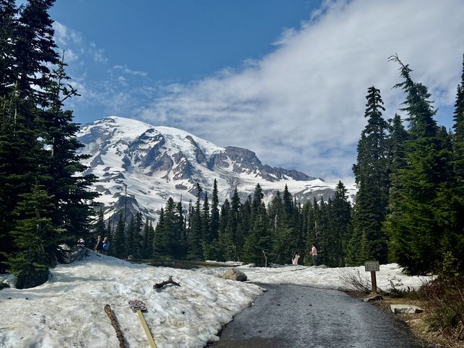
The Nisqually Vista Trail at Mt. Rainier National Park near Ashford, WA is an easy 1.1-mile loop hike that leads to overlooks high above the Nisqually Valley and features views of Mt. Rainier and its glacier-capped slopes.
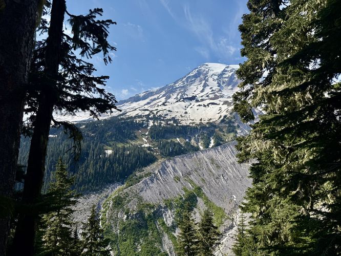
Starting from the trailhead, hikers will find Mt. Rainier towering overhead with its glacier-capped slopes and jagged rock outcroppings. Unless you're visiting on a cloudy day, the mountain will be visible throughout a good portion of this hike. After you climb the staircase at the trailhead, keep-left at the fork to continue along the semi-paved path as it makes its way out toward eastern cliffs of the Nisqually Valley.
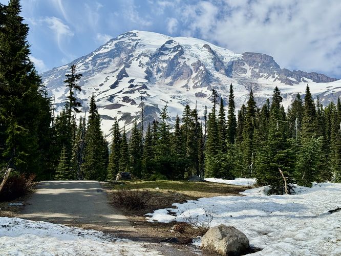
The trail winds in and out of evergreen forests where Mt. Rainier will pop-up from time to time, providing visitors with spectacular views without having to walk very far. This route leads hikers clockwise along the loop, so keep-left at trail junctions to follow along the same path. Eventually, the trail dips back into the forest for a short while, between miles 0.26 and 0.55.
Snowpack: If you arrive in late spring or early summer, you'll likely find that the trail is completely covered in several feet of snowpack. This can be dangerous in some places as the snow creates precipices and steep slopes that often plummet 20-feet or more into trees below. Hike at your own risk and bring ice spikes for traction if you assume there will be snow.
Hiking the Nisqually Vistas
This short and easy hike at Mt. Rainier National Park is one of the best quick-hit trails that the park's Paradise area has to offer visitors. While the distance isn't much, you'll get plenty of payouts throughout the trail, even long before you reach the valley overlooks.Starting from the trailhead, hikers will find Mt. Rainier towering overhead with its glacier-capped slopes and jagged rock outcroppings. Unless you're visiting on a cloudy day, the mountain will be visible throughout a good portion of this hike. After you climb the staircase at the trailhead, keep-left at the fork to continue along the semi-paved path as it makes its way out toward eastern cliffs of the Nisqually Valley.
The trail winds in and out of evergreen forests where Mt. Rainier will pop-up from time to time, providing visitors with spectacular views without having to walk very far. This route leads hikers clockwise along the loop, so keep-left at trail junctions to follow along the same path. Eventually, the trail dips back into the forest for a short while, between miles 0.26 and 0.55.
Nisqually Vista & Mt. Rainier Views - Mile 0.55
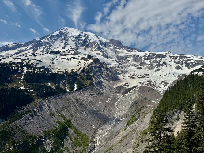
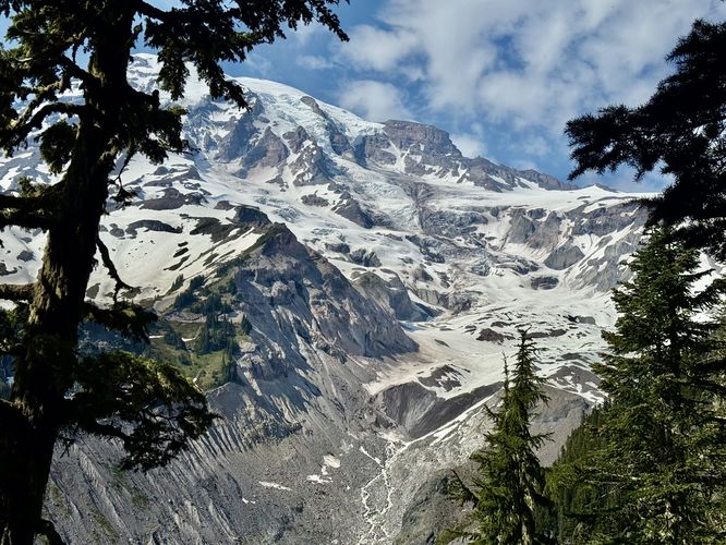
After the trail curves around through the forest, near mile 0.5, it juts out to reach the eastern cliffs that sit high above the Nisqually Valley. Here, around mile 0.55, is the named vista — Nisqually Vista. From the top of the Nisqually Valley, the Nisqually Vista provides breathaking views of Mt. Rainier, its glacier and snow-capped slopes, along with the massive hundreds-of-feet tall waterfalls that spill down into the valley below. The expansive views of Mt. Rainier are difficult for the brain to comprehend, but the breathtaking scenery is well-worth the short hike. The views along the route aren't over though!More Nisqually Vistas - Mile 0.55 to 0.65
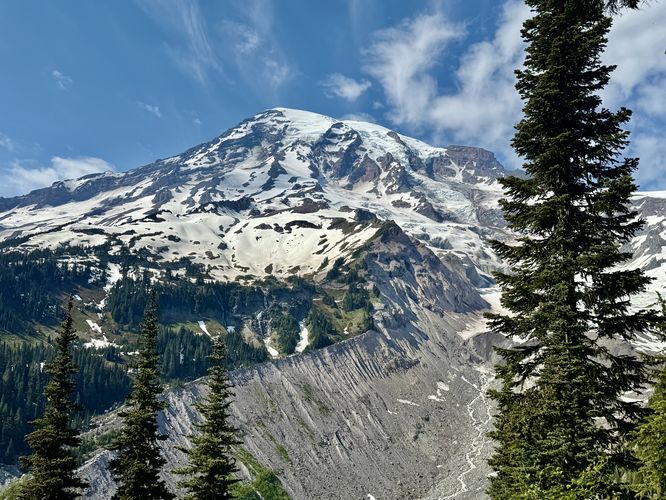
While the views are similar, if not identical, hikers will find three more vista points along the cliffs above the Nisqually Valley. Between miles 0.55 and 0.65 are several spots where you can stop to appreciate similar views of Mt. Rainier from slightly-different perspectives. While some of these views are a bit more obstructed by the evergreen trees that surround them, they're a great way to get away from other hikers or let people pass you on the trail while you soak up the scenery.Hiking Out - Mile 0.65 to 1.1
After exploring the vistas high above the Nisqually Valley, the trail leads hikers back to parking by following a path that winds through the forest. Along the way, you'll have opportunities to turn around and find more views of Mt. Rainier as it pokes its glacier-capped peak over and between the evergreens. Finally, the trail ends around mile 1.1 at the parking lot for an easy but scenic day hike at Mt. Rainier National Park.Parking & Fees
Hikers will find a massive parking lot at the coordinates provided, located just west of the Paradise visitor center parking lot. The lot is large enough to fit many dozens of vehicles as of June 2025. As of June 2025, there's a $25 entry fee for the park which is good for several days. If you plan ahead, you can speed up your entry with an Annual National Park's Pass.Pets
All pets, including dogs, are not allowed on any trails within Mt. Rainier National Park, so please leave your dogs at home.Warning
Cliffs: This hike follows along a cliff line above the Nisqually Valley. For your own safety, always stay on-trail and do not cross the fences at the vistas as there are sheer drop-offs that plummet for hundreds of feet.Snowpack: If you arrive in late spring or early summer, you'll likely find that the trail is completely covered in several feet of snowpack. This can be dangerous in some places as the snow creates precipices and steep slopes that often plummet 20-feet or more into trees below. Hike at your own risk and bring ice spikes for traction if you assume there will be snow.