The Nailiilihaele Falls & Dam is an easy 0.1-mile out-and-back walk that leads to an old dam with a small spillway waterfall and features views of small cascades within the Nailiilihaele Stream from the Road to Hana.
Walk Description
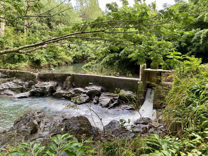
This is not a hike, but rather a short walk that leads along the Road to Hana (HI-360) and down a trail that leads up the Nailiilihaele Stream. Where the trail "ends" is an old dam that includes a very small human-made spillway waterfall. On the right-side of the dam, which is arguably more-interesting, lies a human-made flume that sends water down the stream at a faster rate than the small spillway waterfall. This human-made water flume cuts about 5-feet deep and 4-feet wide into the bedrock, then cuts a tunnel through the hillside, sending water down a separate part of the stream. The dam itself appears to be still in-use as it holds back a large amount of water upstream in a reservoir.
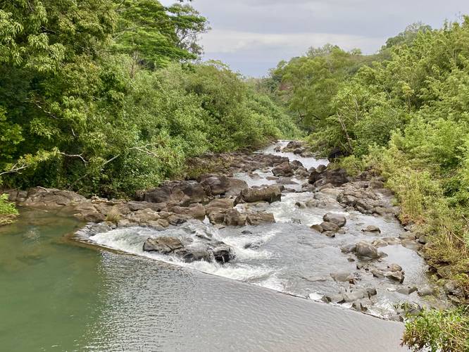
After visiting the old dam, or before heading down the trail, walkers can quickly check out the stream as it passes under the Road to Hana and out toward the ocean. Very small waterfalls can be seen from the road, facing downstream.
Parking
Visitors can find a parking turnout at the coordinates provided (on the east side of the bridge) or, more safely, there's a similar-sized parking turnout on the west side of the bridge as well.
Warnings
Flash Floods: Hawaii is known for their flash floods and this stream is no exception. It's best to keep an eye on the weather, especially upstream, before heading out to this or any stream in Hawaii.
Traffic: If parking on the east side of the bridge that spans the stream, watch the traffic flow and give vehicles the right-of-way before crossing the one-lane bridge.
Respecting the Land
Hawaiian land is considered sacred to native Hawaiians and many locals, so please stay on-trail, take nothing but photos, and leave nothing but footprints. Respect the locals - don't stay for long and have a backup hike planned in case the parking lot is full.
Walk Description
This is not a hike, but rather a short walk that leads along the Road to Hana (HI-360) and down a trail that leads up the Nailiilihaele Stream. Where the trail "ends" is an old dam that includes a very small human-made spillway waterfall. On the right-side of the dam, which is arguably more-interesting, lies a human-made flume that sends water down the stream at a faster rate than the small spillway waterfall. This human-made water flume cuts about 5-feet deep and 4-feet wide into the bedrock, then cuts a tunnel through the hillside, sending water down a separate part of the stream. The dam itself appears to be still in-use as it holds back a large amount of water upstream in a reservoir.
After visiting the old dam, or before heading down the trail, walkers can quickly check out the stream as it passes under the Road to Hana and out toward the ocean. Very small waterfalls can be seen from the road, facing downstream.
Parking
Visitors can find a parking turnout at the coordinates provided (on the east side of the bridge) or, more safely, there's a similar-sized parking turnout on the west side of the bridge as well.
Warnings
Flash Floods: Hawaii is known for their flash floods and this stream is no exception. It's best to keep an eye on the weather, especially upstream, before heading out to this or any stream in Hawaii.
Traffic: If parking on the east side of the bridge that spans the stream, watch the traffic flow and give vehicles the right-of-way before crossing the one-lane bridge.
Respecting the Land
Hawaiian land is considered sacred to native Hawaiians and many locals, so please stay on-trail, take nothing but photos, and leave nothing but footprints. Respect the locals - don't stay for long and have a backup hike planned in case the parking lot is full.