Munising Falls at Pictured Rocks National Lakeshore in Munising, Michigan is an easy 0.4-mile out-and-back hike that leads to the 50-foot waterfall, Munising Falls.
Universal Accessibility
This trail is universally accessible from the parking lot to the view downstream at the base of Munising Falls. Note that the two other viewing areas are not universally accessible. The trail follows a crushed stone path.
Hike Description
While this is not much of a hike, this short walk leads out to the 50-foot waterfall, Munising Falls, and is one of the most popular day hikes at Pictured Rocks National Lakeshore. The trail leads into the gorge and runs along Munising Falls Creek before reaching a staircase junction on the right-hand side. Skip the staircase (for now) to reach the base of the waterfall at mile 0.16.
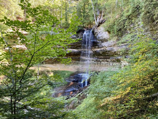
Munising Falls Base View - Mile 0.16
At mile 0.16, hikers will reach the wooden viewing platform which sits just downstream from the base of Munising Falls. This is by far the best place to get a view of the waterfall as it cascades down the sandstone cliff.
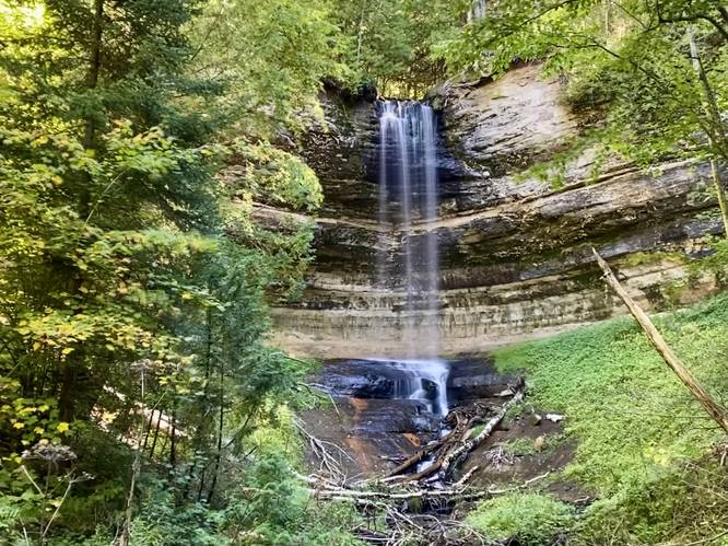
Munising Falls Upper View - Mile 0.19
After visiting the lower viewing platform along the creek, hikers may want to explore the other viewing opportunities. This track leads to both, but first hits the northern "Upper View" platform at mile 0.19. The view here is a bit obstructed, but still nice.
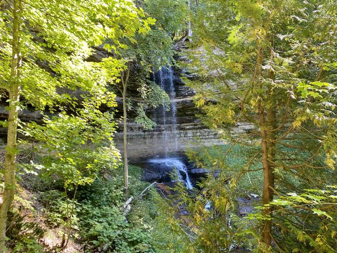
Munising Falls Cliff View - Mile 0.25
After visiting the two closest viewing platforms, hikers can backtrack and hike up the first set of stairs to reach the southern "Cliff View" of Munising Falls. This cliff area is really interesting as it brings hikers around, and slightly under, a sandstone cliff to reach the viewing platform. This viewing platform, as of September 2022, had better views than the "Upper View".
Hiking out is as simple as heading back to the parking lot - whether from the staircase(s) or from the main creek side waterfall view.
Parking & Fees
Hikers will find a large parking lot at the coordinates provided, located off of Sand Point Road in Munising. The lot is large enough to fit several dozen vehicles. There's a $10 fee, cash-only, and must have exact change, as of September 2022.
Popularity
This is by far one of the most popular hikes at Pictured Rocks National Lakeshore. The trail is usually busy unless you show up early.
Pets
Dogs are allowed and their waste must be carried out by the hiker.
Warnings
Erosion, falling rocks: Due to the erosion of the sandstone cliffs, hikers must stay on the trail at all times to avoid any accidental injuries.
Universal Accessibility
This trail is universally accessible from the parking lot to the view downstream at the base of Munising Falls. Note that the two other viewing areas are not universally accessible. The trail follows a crushed stone path.
Hike Description
While this is not much of a hike, this short walk leads out to the 50-foot waterfall, Munising Falls, and is one of the most popular day hikes at Pictured Rocks National Lakeshore. The trail leads into the gorge and runs along Munising Falls Creek before reaching a staircase junction on the right-hand side. Skip the staircase (for now) to reach the base of the waterfall at mile 0.16.
Munising Falls Base View - Mile 0.16
At mile 0.16, hikers will reach the wooden viewing platform which sits just downstream from the base of Munising Falls. This is by far the best place to get a view of the waterfall as it cascades down the sandstone cliff.
Munising Falls Upper View - Mile 0.19
After visiting the lower viewing platform along the creek, hikers may want to explore the other viewing opportunities. This track leads to both, but first hits the northern "Upper View" platform at mile 0.19. The view here is a bit obstructed, but still nice.
Munising Falls Cliff View - Mile 0.25
After visiting the two closest viewing platforms, hikers can backtrack and hike up the first set of stairs to reach the southern "Cliff View" of Munising Falls. This cliff area is really interesting as it brings hikers around, and slightly under, a sandstone cliff to reach the viewing platform. This viewing platform, as of September 2022, had better views than the "Upper View".
Hiking out is as simple as heading back to the parking lot - whether from the staircase(s) or from the main creek side waterfall view.
Parking & Fees
Hikers will find a large parking lot at the coordinates provided, located off of Sand Point Road in Munising. The lot is large enough to fit several dozen vehicles. There's a $10 fee, cash-only, and must have exact change, as of September 2022.
Popularity
This is by far one of the most popular hikes at Pictured Rocks National Lakeshore. The trail is usually busy unless you show up early.
Pets
Dogs are allowed and their waste must be carried out by the hiker.
Warnings
Erosion, falling rocks: Due to the erosion of the sandstone cliffs, hikers must stay on the trail at all times to avoid any accidental injuries.