Mt. Wantastiquet & Madame Sherri Castle at Madame Sherri Forest in Chesterfield, New Hampshire is a moderate 3.9-mile out-and-back hike that features stunning views of Indian Pond, the Connecticut River, downtown Brattleboro, and views into Vermont from Wantastiquet Mountain.
Hiking to Indian Pond - Mile 0.35
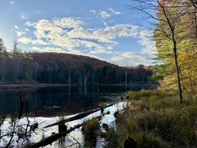
Hikers will reach a right-hand turn near mile 0.35 in the route provided which leads uphill further toward Indian Pond and toward the summit of the mountain. This right-hand turn follows a fairly-easy grade as it runs uphill. Near mile 0.7, hikers will reach another right-hand turn which heads directly up the mountain, however, along the way is a short stop with a view of Indian Pond from a small hill that sits just above its northern shore. The view here is a nice place to take a little break before sending it up the steepest part of the hike.
Slippery leaves/rocks: This trail leads through areas of jutting rocks including slabs of slanted granite bedrock. When wet, these rocks can be very slippery. During autumn, the leaves increase the chance you might get hurt by accidentally sliding down the bedrock which can often be hidden below. Take your time and evaluate each step to ensure your own safety.
Exploring the Madame Sherri Castle
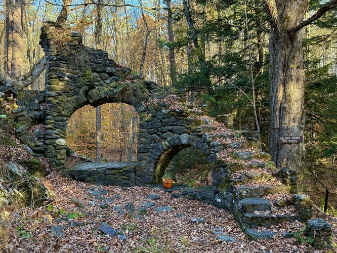
This hike begins along the eastern slopes of Mt. Wantastiquet where the trail leads into the Madame Sherri Forest by crossing a footbridge that spans an outflow creek from a dammed pond. Within a couple-hundred feet of the trailhead is a right-hand turn, with signage, for the Madame Sherri "Castle" -- this route leads to the castle first. Hikers will find the remnants of a 1920's home ("castle") owned by Madame Antoinette Sherri. The main attraction for the castle is the roman arch stairway that once lead up to Madame Sherri's "castle", which can be found nestled within this tranquil forest. Do not climb the arched steps, for safety but also to keep them intact for future hikers. Instead, you can walk up the large stone steps on the left that lead right into the home. From the top of the hill, you'll be standing inside of Madame Sherri's castle with its stone foundation, pillars, and mostly-destroyed fireplace in the center. During our hike here in October 2024, we found an old rug sitting in the middle of the remnants of Madame Sherri's home, however, this must be a new "addition" by locals who maybe were looking for a way to get rid of one of their rugs. Regardless, the rug provides an reminder that you're standing inside of someone's old home.Hiking up Mt. Wantastiquet
After exploring the Madame Sherri Castle, the hike up to the top of Mt. Wantastiquet is moderate and rocky. First, hikers will pass a beaver pond located near parking as the Ann Stokes LoopTrail traverses along its western shores.Hiking to Indian Pond - Mile 0.35
Hikers will reach a right-hand turn near mile 0.35 in the route provided which leads uphill further toward Indian Pond and toward the summit of the mountain. This right-hand turn follows a fairly-easy grade as it runs uphill. Near mile 0.7, hikers will reach another right-hand turn which heads directly up the mountain, however, along the way is a short stop with a view of Indian Pond from a small hill that sits just above its northern shore. The view here is a nice place to take a little break before sending it up the steepest part of the hike. Steep Ascent & View of Indian Pond - Mile 0.8 to 1.1
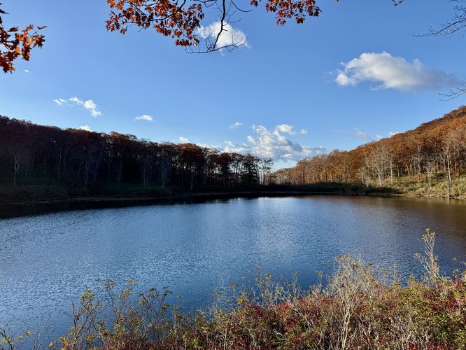
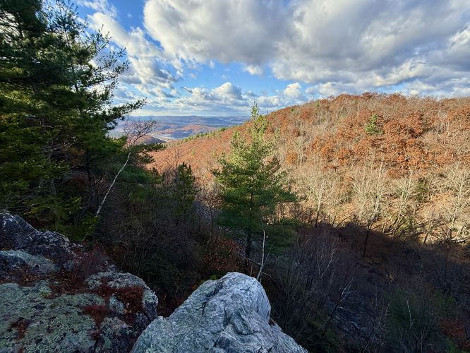
After exploring the low-elevation view of Indian Pond, the trail leads up the steepest section of Mt. Wantastiquet where hikers will find a trail littered with jutting rocks and slanted slabs of granite rock. This section of the hike, during most of the year, is not too difficult but you must mind the rocks to not twist an ankle. Note that during autumn, the trail is littered with leaves and makes for a much-more dangerous hike on this steep slope as you can easily surf down the granite slabs of bedrock without any warning. On your way up to the top of the mountain is a beautiful view of Indian Pond and the surrounding hills that surround it. The view of Indian Pond is located just off-trail near mile 0.95.Mine Ledge Overlook - Mile 1.45 1.5
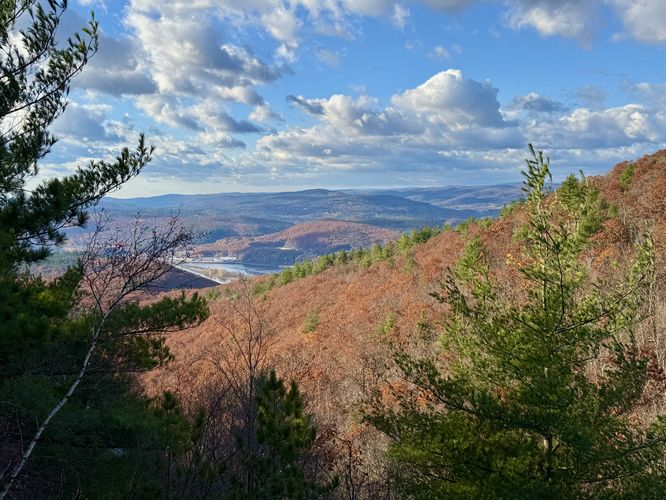
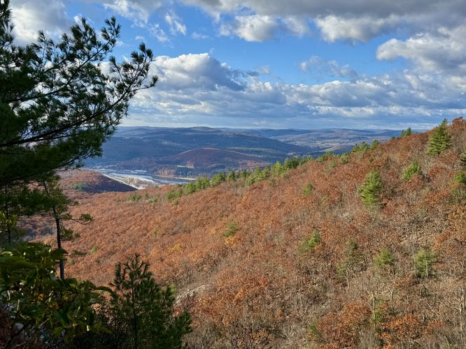
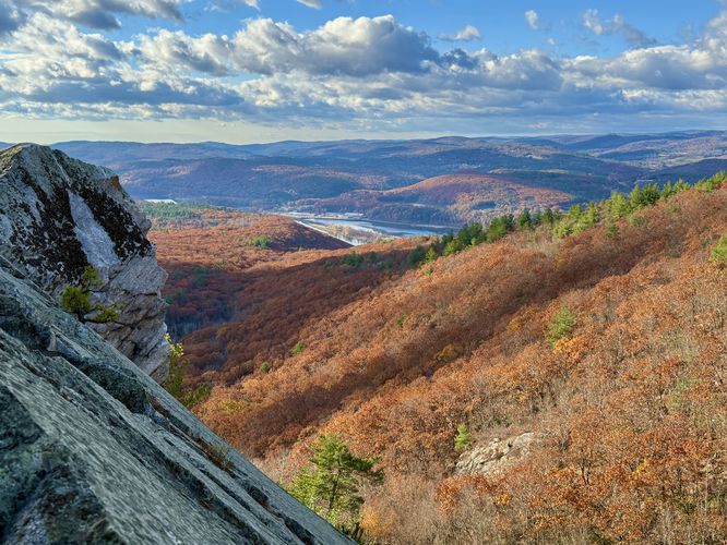
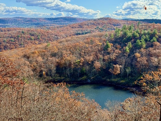
Once you reach the "top" of Mt. Wantastiquet, the trail continues to undulate its way through the forest over easy ground and jutting or sloped slabs of granite bedrock. Near mile 1.4, hikers will reach a junction in the trail with signage for "Mine Ledge" -- take this turn to head to the Mine Ledge overlooks. The overlooks at Mine Ledge begin around mile 1.45 where you'll find several rocky outcroppings and southwestern views into Vermont and the Connecticut River below. Watch your step as there are sheer drops at Mine Ledge that plummet over 60-feet to an abandoned mine area below. If you hike further, traversing over more jutting bedrock, you'll reach the best view from Mine Ledge, located near mile 1.5. Here, you'll find sweeping southwestern views into Vermont, the Connecticut River, and distant mountains. To the east is another view, but is less stunning than the southwestern view. Regardless, Mine Ledge is by-far the best view along this hike and should be considered a spot to take a break to take-in the scenery.Hiking to the Brattleboro Overlook - Mile 1.5 to 2.1
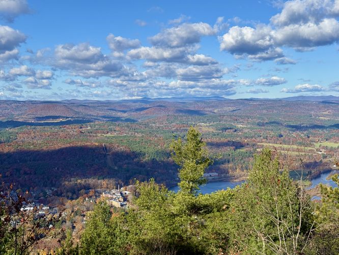
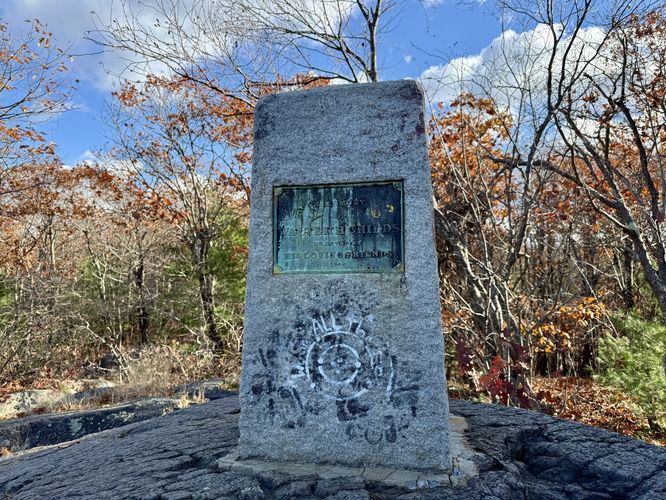
After exploring the overlooks at Mine Ledge, the hike leads back to the main path where you'll take another left-hand turn to continue north and west along the blue-blazed trail. The trail immediately heads down another series of jutting granite bedrock to where it leads to more undulating rocky terrain. The trail leads through the forest, with really nothing to see but more jutting bedrock along the way. Eventually the trail reaches a wider and easier-to-follow path which leads northwest. At mile 2.05 hikers will find a left-hand turn that leads to the Brattleboro Overlook atop Mt. Wantastiquet. At mile 2.1, you'll reach a granite bedrock perch with a stone monument. Here, you'll find westerly views into Vermont with Brattleboro's downtown and the Connecticut River below. The views here are less stunning than at Mine Ledge, but this overlook is a great way to enjoy more views into Vermont including the bustling Brattleboro.Hiking Out - Mile 2.1 to 3.9
This route follows the opposite trail to reach parking, so there isn't much else to note about the hike out. The only warning I'd suggest to hikers is to be mindful of the steep and rocky terrain as you descend the mountain, especially during autumn when the leaves make for a somewhat dangerous descent. On your way out, don't forget to stop at the Indian Pond overlook located on the slopes of the mountain which will be your last good view along this hike. You can opt to explore the Madame Sherri Castle one more time or check out the beaver pond near parking. At mile 3.9, you'll reach the parking lot to wrap up the hike.History - Who was Madame Antoinette Sherri?
The Madame Sherri Forest is named for Madame Antoinette Sherri, a Paris-born theatrical costume designer who entertained lavishly during parties at her Chesterfield "castle" in the 1920's. Her French chateau featured extensive stonework including a roman arch stairway, ornate interior, and designed landscape gardens. Today, ancient sugar maples surround a stone foundation and stairway, a large empty fireplace taper to a freestanding chimney. This is all that remains of the former summer home of Madame Sherri who died in Brattleboro on October 21, 1965. Late that year, Ann Stokes bought this property from Charles LeMarie. Ann Stokes loved this property and its theatrical legay. She donated the Madame Sherri Forest to the Society for the Protection of NH Forests in February of 1991.Parking
Hikers will find a medium-sized parking lot at the coordinates provided, located on the west side of Gulf Road in Chesterfield. The lot is large enough to fit about 15 vehicles as of October 2024. On weekends the parking lot fills up by 10AM or earlier. When we hiked here, we arrived at 8:30AM and was the 2nd car in the lot on a Saturday. Seasonal parking: please note that this dirt road might not be plowed during the winter -- I did not look into this with the town.Pets
Dogs are allowed only if under control at all times and must be cleaned up after. Dogs are recommended to be leashed, but this area is an off-leash dog area.Warning
Steep cliffs: This hike leads to steep cliffs with plummeting drop-offs. It's best to watch your step and stay away from the edge of the cliffs for your own safety.Slippery leaves/rocks: This trail leads through areas of jutting rocks including slabs of slanted granite bedrock. When wet, these rocks can be very slippery. During autumn, the leaves increase the chance you might get hurt by accidentally sliding down the bedrock which can often be hidden below. Take your time and evaluate each step to ensure your own safety.