Trail name(s): Mt. Roberts Trail
Location: Ossipee Park Road, Castle in the Clouds Conservation Area, Moultonborough NH
Permitted uses: Hiking, Nature Study, low impact activities such as snowshoeing and cross country skiing
Prohibited uses: No Bikes, No Camping or overnight use, No fires. No motorized vehicles
Hours: Open during daylight hours.
Fees and Parking: There is no fee to park or to use the trails. There is an enormous amount of parking at the Castle in the Clouds Conservation area.
Pets: Dogs are allowed on the trails and owners are expected to clean up after them and to keep them leashed. Dog waste bags are provided as well as a trash receptacle for dog waste near the Shannon Pond road entrance.
Accessibility: This hike is not wheelchair accessible.
Hiker amenities: There is no information kiosk at this trailhead. If hikers would like information about the trail, they need to visit the information kiosk at Shannon Pond. At Shannon Pond hikers will find a trash bin, dog waste bags and a dog waste bin. However, hikers are asked to carry out all trash. There are no restrooms. There are picnic tables near Shannon Pond, across from the trailhead parking area.
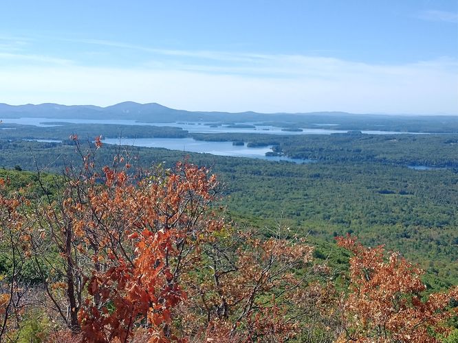
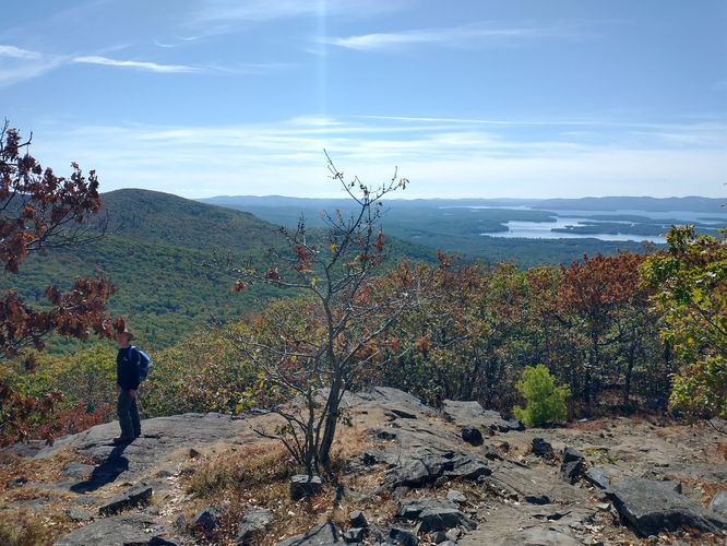
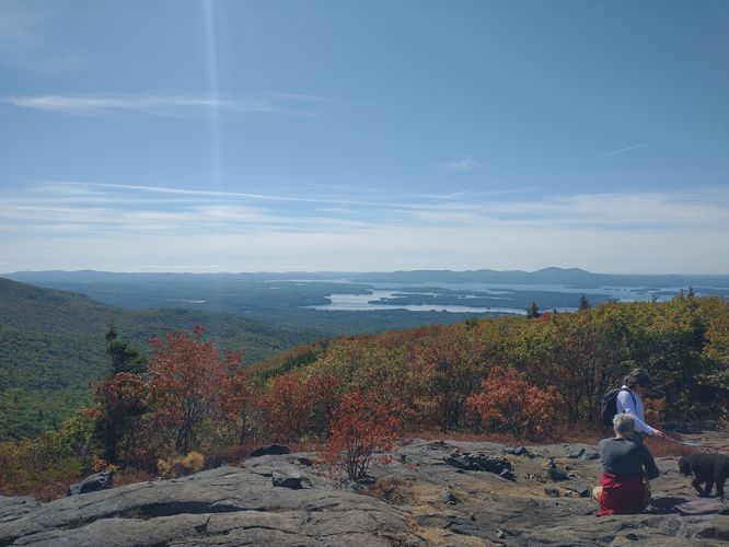
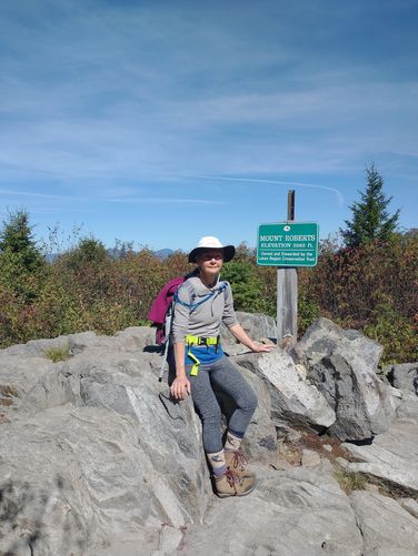
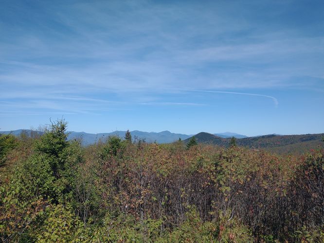
Length and Trail information: The trail is approximately 5.1 miles long and was hiked as an out and back hike. This hike is considered to be moderate to hard and is marked by an orange diamond shaped blaze. Our goal for this hike was to reach the Summit of Mt. Roberts to enjoy the views. From the parking area, we headed to the left following the signage directing us away from Shannon Pond down the paved road and past the restricted Employee parking area. The distance from the parking area to the trailhead is about a quarter of a mile and the paved road turns to gravel just past the fence. There are trail signs posted on a nearby tree and at the entrance of the trailhead off to the right in a large open field. The trail is narrow, a bit wider than a cow path that goes between some shrubs until it reaches the forest. Once inside the forest the trail widens and resembles a class 6 road. The ascent begins and is very gentle at this part of the hike. The trail winds along the edge of the field and back into the woods. Once past the field, the trail begins to ascend in earnest and the substrate is very rocky. The ascent is not overly steep, but it is steady and your heart rate will be pumping. The payoff for your effort will be the multiple open flat rock plaza viewing areas that offer you a beautiful view of the valley below. We probably stopped at least 5 times on our ascent, just to take in the beauty that surrounded us. As we continued our ascent the trail went through a thick Hemlock forest. This offered a nice break from the sun and the temperature dropped dramatically. One of the things we noticed while hiking through this section was the amount of needle drop that we saw on the trail and trail side. There was so much Hemlock needle drop that the trail was slippery. We have never in all our years of hiking experienced this kind of event and we were concerned that this was due to the drought we are currently experiencing in the State of NH. Sadly during our hike we noticed a lot of trees that were dry and dead, and much of the vegetation trail side was crispy and dry to the point of being tinder. One lightning strike here, and the forest could easily ignite. Shortly after hiking in the Hemlock Forest, we reached our goal and found the marker for the Summit of Mt. Roberts. To our surprise we could see all the way to Mt. Chocorua from atop the rocky summit. We didn't spend too much time at the summit, because to be honest, the views on the way up were nicer. We hiked back down the trail to one of our previous stops and had a picnic lunch before packing up and heading back down the trail to the parking area. This is a great hike with great views. It can be a bit strenuous, but totally worth the effort it took to get there.
Location: Ossipee Park Road, Castle in the Clouds Conservation Area, Moultonborough NH
Permitted uses: Hiking, Nature Study, low impact activities such as snowshoeing and cross country skiing
Prohibited uses: No Bikes, No Camping or overnight use, No fires. No motorized vehicles
Hours: Open during daylight hours.
Fees and Parking: There is no fee to park or to use the trails. There is an enormous amount of parking at the Castle in the Clouds Conservation area.
Pets: Dogs are allowed on the trails and owners are expected to clean up after them and to keep them leashed. Dog waste bags are provided as well as a trash receptacle for dog waste near the Shannon Pond road entrance.
Accessibility: This hike is not wheelchair accessible.
Hiker amenities: There is no information kiosk at this trailhead. If hikers would like information about the trail, they need to visit the information kiosk at Shannon Pond. At Shannon Pond hikers will find a trash bin, dog waste bags and a dog waste bin. However, hikers are asked to carry out all trash. There are no restrooms. There are picnic tables near Shannon Pond, across from the trailhead parking area.
Length and Trail information: The trail is approximately 5.1 miles long and was hiked as an out and back hike. This hike is considered to be moderate to hard and is marked by an orange diamond shaped blaze. Our goal for this hike was to reach the Summit of Mt. Roberts to enjoy the views. From the parking area, we headed to the left following the signage directing us away from Shannon Pond down the paved road and past the restricted Employee parking area. The distance from the parking area to the trailhead is about a quarter of a mile and the paved road turns to gravel just past the fence. There are trail signs posted on a nearby tree and at the entrance of the trailhead off to the right in a large open field. The trail is narrow, a bit wider than a cow path that goes between some shrubs until it reaches the forest. Once inside the forest the trail widens and resembles a class 6 road. The ascent begins and is very gentle at this part of the hike. The trail winds along the edge of the field and back into the woods. Once past the field, the trail begins to ascend in earnest and the substrate is very rocky. The ascent is not overly steep, but it is steady and your heart rate will be pumping. The payoff for your effort will be the multiple open flat rock plaza viewing areas that offer you a beautiful view of the valley below. We probably stopped at least 5 times on our ascent, just to take in the beauty that surrounded us. As we continued our ascent the trail went through a thick Hemlock forest. This offered a nice break from the sun and the temperature dropped dramatically. One of the things we noticed while hiking through this section was the amount of needle drop that we saw on the trail and trail side. There was so much Hemlock needle drop that the trail was slippery. We have never in all our years of hiking experienced this kind of event and we were concerned that this was due to the drought we are currently experiencing in the State of NH. Sadly during our hike we noticed a lot of trees that were dry and dead, and much of the vegetation trail side was crispy and dry to the point of being tinder. One lightning strike here, and the forest could easily ignite. Shortly after hiking in the Hemlock Forest, we reached our goal and found the marker for the Summit of Mt. Roberts. To our surprise we could see all the way to Mt. Chocorua from atop the rocky summit. We didn't spend too much time at the summit, because to be honest, the views on the way up were nicer. We hiked back down the trail to one of our previous stops and had a picnic lunch before packing up and heading back down the trail to the parking area. This is a great hike with great views. It can be a bit strenuous, but totally worth the effort it took to get there.