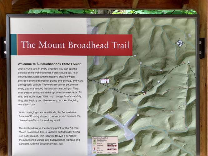
The Mt. Broadhead Trail at Susquehennock State Forest near Galeton, Pennsylvania is a moderate 8.5-mile loop trail that features a stunning view of Potter County's mountains from the Water Tank Vista and includes a seldom-seen mountain ascent that follows an old railroad bed.
Trails
This hike follows one trail, the Mt. Broadhead Trail (yellow blazes), which is technically composed of several different trails that encompass Mount Broadhead. This hike follows yellow blazes - some of which are hard to find.
Hike Description
This hike begins at the eastern-most trailhead along PA-44 at the parking coordinates provided and follows the Mt. Broadhead Trail in a counterclockwise direction. Hikers should note that this seldom-walked trail has a lot of overgrowth during warmer months (May - October) and a lot of this overgrowth is either ferns, nettles, some briar bushes, or all of the above. The most offensive areas for overgrowth are located in the northeast section of the loop with regard to ferns and nettles, (i.e. beginning of this hike), the southwest section of the loop with regard to nettles, and the last 1-mile with regard to ferns and grass. Due to the overgrowth, sometimes hiking on this trail can feel a bit overwhelming while looking for the next yellow blaze marker.
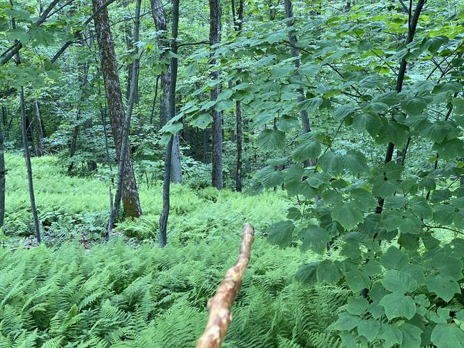
Sea of Ferns - Mile 0 to 1.7
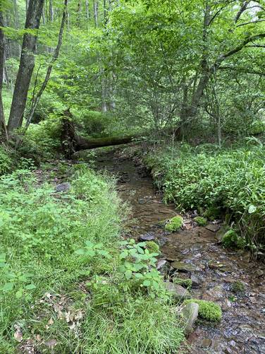
Hikers will encounter a sea of ferns for the first ~1.7-miles. The trail will first begin its descent toward the main branch of the Upper Dry Hollow Run creek as it passes through endless ferns and some small patches of nettles. The trail follows right next to the creek bed as it makes its way down the mountain hollow; however in late June, the creek was totally dried up and seems to be mostly fed by snowmelt. One tricky section is around mile 0.15 as the trail crosses an ATV path or service road as it continues its descent down into the mountain hollow. At the bottom of the mountain, hikers will reach the main branch of the Upper Dry Hollow Run creek. Here, the trail heads west as it meanders through old Hawthorn trees and some apple trees. Around mile 1.7, the trail will head back up Mount Broadhead into a mountain hollow.
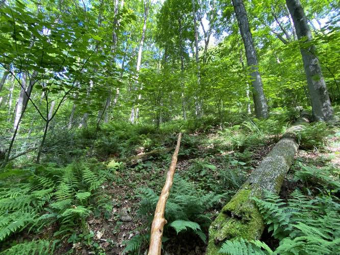
Trail Scramble - Mile 2.1 to 2.2
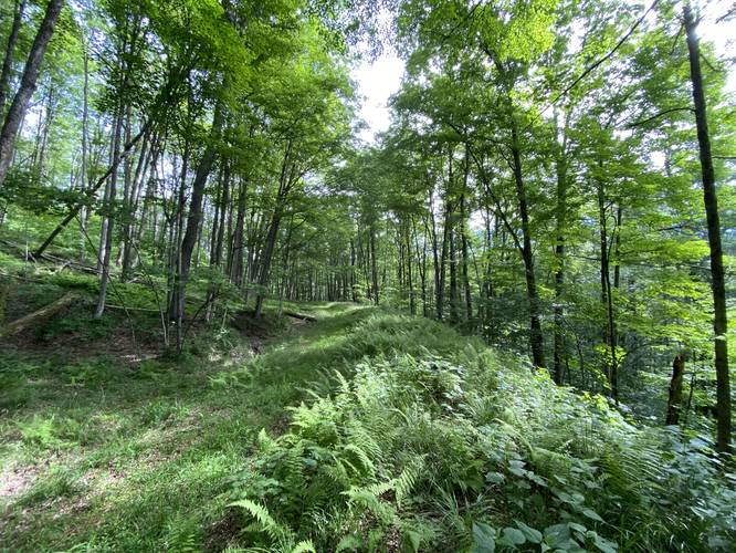
Around mile 2.1, hikers will reach a right-hand turn in the trail where the trail heads almost straight uphill to the old train bed for the Buffalo and Susquehanna Railroads. This is the most difficult section of the hike, in terms of sheer elevation difficulty, but it does not last long. Once at the top of the hill, the trail heads north and then west to wrap around the mountain as it follows the old railroad bed. Hikers with a keen eye may be able to spot slag that was used to build up the bed. Between here and the Water Tank Vista, hikers will not find a whole lot other than a very nice gradual elevation grade, rock ledges, mountain laurel, slag, and some mountain ravines where fill, rock, and soil were built up to construct the railroad bed. Hikers will find a trail registry around mile 4.2 - it's smart to sign-in just in case something happens while on the trail.
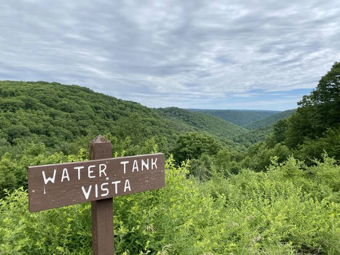
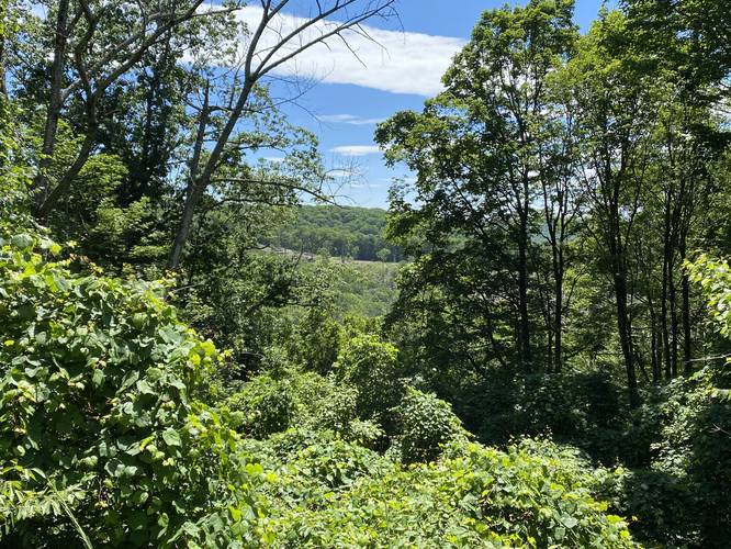
Water Tank Vista - Mile 4.3
At mile 4.3, hikers will reach PA-44 where they'll find Water Tank Vista sitting just off-trail to the west. This is the best vista along the route and along Mount Broadhead. It's worth spending some time here before continuing onward. If you choose to continue along the entire loop, the continuation for the trail can be found just east of the vista on the opposite side of the road.
Water Tank Vista to STS - Mile 4.3 to 5.8
Between miles 4.3 (Water Tank Vista) and 5.8 (STS junction), hikers will encounter a lot of overgrowth in the form of grass, briar, and nettles as the trail descends Mount Broadhead once again. Note that as of June 2022, between miles 4.5 and 4.75 there was a sea of nettles. The trail then meanders down the mountain along a thick forest of young trees - a clear sign that this area had been logged not too long ago (circa 2012) as the trees were not much older than ~10 years or so. The forest then begins to open up once more as the hiker leaves the open area and gets back into the older forest. Not long after, around mile 5.8, you'll reach a junction with the Susquehannock Trail System (STS) where a campsite can also be found. Here, take a left-hand turn to follow the STS.
STS to Log Grade Trail - Mile 5.8 to 6.25
Along the STS, hikers will follow a very well-maintained footpath as it cuts its way through the forest alongside Hogback Hollow Run. Some keen-eyed hikers may be able to spot large Ostrich Ferns off-trail - some growing well-over 6-feet tall.
Log Grade Trail to Parking - Mile 6.25 to 8.5
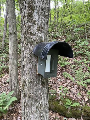
At mile 6.25, hikers will reach the Log Grade Trail junction - a continuation of the Mt. Broadhead Trail. Take a left-hand turn here to start the final ascent up Mount Broadhead. Along the way, as of June 2022, hikers will cross a fallen tree with a rope to guide across Hogback Hollow Run creek which helps keep your feet dry. Eventually, the trail will become more difficult - around mile 7.2 as it begins a steeper climb. Hikers will find a trail registry at mile 7.9, a small off-trail view around mile 8, and then will reach the parking lot at ~8.5-miles to complete the hike.
Parking
Hikers will find two parking turnouts for this hike. The parking coordinates will lead to the eastern trailhead where about four vehicles can fit in the turnout. Hikers can also start the hike at the Water Tank Vista where about three vehicles can fit. Please note that the Water Tank Vista is a popular drive-up view for tourists and visitors to the area, so it's smart to park at the eastern trailhead (parking coordinates provided).
Pets
Dogs are allowed if leashed and their waste should be carried out by the hiker.
Camping and Backpacking
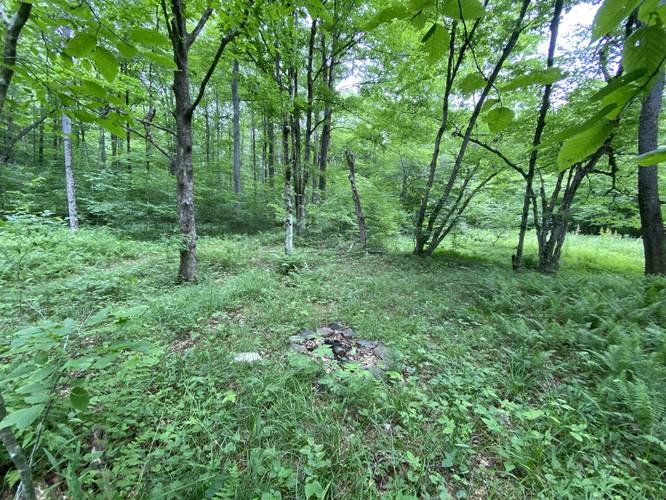
Backpacking is permitted along this trail - please follow all state forest rules and regulations when dispersed / primitive / backcountry camping. Also note that there are not many pre-built campsites along the route since we only found one of these; however, there are plenty of places where one can find a spot to setup a tent or hammock to camp.
Warnings
Lack of water: While this hike is not very difficult, there's not much water along the trails especially during late Spring, Summer, or Fall. Hogback Hollow Run (located along the southern end of the loop) has water, but Upper Dry Hollow Run had no water as of late June, 2022.
No cell service: There's no cell service along this hike except for spots near the summit or ridge of Mount Broadhead.
Timber Rattlesnakes: This area is known to have Timber Rattlesnakes and they often can be found near water sources during hot months drinking or hunting. They can also be found in tall thick grasses in sunny spots or sunning themselves on the trail.
Nettles and briar bushes: There's a bunch of overgrowth along this trail which sometimes includes briar bushes and stinging nettles.
Mountain Name Misspellings
This mount is referred to on some maps as Mt. Brodhead or Mount Brodhead. Even some trail signs on-trail have this misspelling. It appears as though Mt. Broadhead or Mount Broadhead is the proper spelling.
History
The northwestern section of the Mt. Broadhead Trail follows the old railroad bed for the Buffalo and Susquehanna Railroads. This section of the rail line was built in 1895 and operated until flood waters washed it out in 1942. The Goodyear Lumber Company built the rail lines to harvest timber from the vast hemlock forests of Pottery County. The "Switchback Trail" sign located at the western trailhead here indicates an individually-named trail that is part of the Mt. Broadhead Trail system - the "Switchback" referring to railroad switchbacks.
Trails
This hike follows one trail, the Mt. Broadhead Trail (yellow blazes), which is technically composed of several different trails that encompass Mount Broadhead. This hike follows yellow blazes - some of which are hard to find.
Hike Description
This hike begins at the eastern-most trailhead along PA-44 at the parking coordinates provided and follows the Mt. Broadhead Trail in a counterclockwise direction. Hikers should note that this seldom-walked trail has a lot of overgrowth during warmer months (May - October) and a lot of this overgrowth is either ferns, nettles, some briar bushes, or all of the above. The most offensive areas for overgrowth are located in the northeast section of the loop with regard to ferns and nettles, (i.e. beginning of this hike), the southwest section of the loop with regard to nettles, and the last 1-mile with regard to ferns and grass. Due to the overgrowth, sometimes hiking on this trail can feel a bit overwhelming while looking for the next yellow blaze marker.
Sea of Ferns - Mile 0 to 1.7
Hikers will encounter a sea of ferns for the first ~1.7-miles. The trail will first begin its descent toward the main branch of the Upper Dry Hollow Run creek as it passes through endless ferns and some small patches of nettles. The trail follows right next to the creek bed as it makes its way down the mountain hollow; however in late June, the creek was totally dried up and seems to be mostly fed by snowmelt. One tricky section is around mile 0.15 as the trail crosses an ATV path or service road as it continues its descent down into the mountain hollow. At the bottom of the mountain, hikers will reach the main branch of the Upper Dry Hollow Run creek. Here, the trail heads west as it meanders through old Hawthorn trees and some apple trees. Around mile 1.7, the trail will head back up Mount Broadhead into a mountain hollow.
Trail Scramble - Mile 2.1 to 2.2
Around mile 2.1, hikers will reach a right-hand turn in the trail where the trail heads almost straight uphill to the old train bed for the Buffalo and Susquehanna Railroads. This is the most difficult section of the hike, in terms of sheer elevation difficulty, but it does not last long. Once at the top of the hill, the trail heads north and then west to wrap around the mountain as it follows the old railroad bed. Hikers with a keen eye may be able to spot slag that was used to build up the bed. Between here and the Water Tank Vista, hikers will not find a whole lot other than a very nice gradual elevation grade, rock ledges, mountain laurel, slag, and some mountain ravines where fill, rock, and soil were built up to construct the railroad bed. Hikers will find a trail registry around mile 4.2 - it's smart to sign-in just in case something happens while on the trail.
Water Tank Vista - Mile 4.3
At mile 4.3, hikers will reach PA-44 where they'll find Water Tank Vista sitting just off-trail to the west. This is the best vista along the route and along Mount Broadhead. It's worth spending some time here before continuing onward. If you choose to continue along the entire loop, the continuation for the trail can be found just east of the vista on the opposite side of the road.
Water Tank Vista to STS - Mile 4.3 to 5.8
Between miles 4.3 (Water Tank Vista) and 5.8 (STS junction), hikers will encounter a lot of overgrowth in the form of grass, briar, and nettles as the trail descends Mount Broadhead once again. Note that as of June 2022, between miles 4.5 and 4.75 there was a sea of nettles. The trail then meanders down the mountain along a thick forest of young trees - a clear sign that this area had been logged not too long ago (circa 2012) as the trees were not much older than ~10 years or so. The forest then begins to open up once more as the hiker leaves the open area and gets back into the older forest. Not long after, around mile 5.8, you'll reach a junction with the Susquehannock Trail System (STS) where a campsite can also be found. Here, take a left-hand turn to follow the STS.
STS to Log Grade Trail - Mile 5.8 to 6.25
Along the STS, hikers will follow a very well-maintained footpath as it cuts its way through the forest alongside Hogback Hollow Run. Some keen-eyed hikers may be able to spot large Ostrich Ferns off-trail - some growing well-over 6-feet tall.
Log Grade Trail to Parking - Mile 6.25 to 8.5
At mile 6.25, hikers will reach the Log Grade Trail junction - a continuation of the Mt. Broadhead Trail. Take a left-hand turn here to start the final ascent up Mount Broadhead. Along the way, as of June 2022, hikers will cross a fallen tree with a rope to guide across Hogback Hollow Run creek which helps keep your feet dry. Eventually, the trail will become more difficult - around mile 7.2 as it begins a steeper climb. Hikers will find a trail registry at mile 7.9, a small off-trail view around mile 8, and then will reach the parking lot at ~8.5-miles to complete the hike.
Parking
Hikers will find two parking turnouts for this hike. The parking coordinates will lead to the eastern trailhead where about four vehicles can fit in the turnout. Hikers can also start the hike at the Water Tank Vista where about three vehicles can fit. Please note that the Water Tank Vista is a popular drive-up view for tourists and visitors to the area, so it's smart to park at the eastern trailhead (parking coordinates provided).
Pets
Dogs are allowed if leashed and their waste should be carried out by the hiker.
Camping and Backpacking
Backpacking is permitted along this trail - please follow all state forest rules and regulations when dispersed / primitive / backcountry camping. Also note that there are not many pre-built campsites along the route since we only found one of these; however, there are plenty of places where one can find a spot to setup a tent or hammock to camp.
Warnings
Lack of water: While this hike is not very difficult, there's not much water along the trails especially during late Spring, Summer, or Fall. Hogback Hollow Run (located along the southern end of the loop) has water, but Upper Dry Hollow Run had no water as of late June, 2022.
No cell service: There's no cell service along this hike except for spots near the summit or ridge of Mount Broadhead.
Timber Rattlesnakes: This area is known to have Timber Rattlesnakes and they often can be found near water sources during hot months drinking or hunting. They can also be found in tall thick grasses in sunny spots or sunning themselves on the trail.
Nettles and briar bushes: There's a bunch of overgrowth along this trail which sometimes includes briar bushes and stinging nettles.
Mountain Name Misspellings
This mount is referred to on some maps as Mt. Brodhead or Mount Brodhead. Even some trail signs on-trail have this misspelling. It appears as though Mt. Broadhead or Mount Broadhead is the proper spelling.
History
The northwestern section of the Mt. Broadhead Trail follows the old railroad bed for the Buffalo and Susquehanna Railroads. This section of the rail line was built in 1895 and operated until flood waters washed it out in 1942. The Goodyear Lumber Company built the rail lines to harvest timber from the vast hemlock forests of Pottery County. The "Switchback Trail" sign located at the western trailhead here indicates an individually-named trail that is part of the Mt. Broadhead Trail system - the "Switchback" referring to railroad switchbacks.