The Mount Tallac hike at the Eldorado National Forest in South Lake Tahoe, California is a strenuous 9-mile out-and-back trail that features a mountain summit and beautiful views.
This hike also runs through the Desolation Wilderness which is a part of the Eldorado National Forest. Because of the stunning views of Fallen Leaf Lake, Lake Tahoe, and the Desolation Wilderness, this trail is very popular during warmer months.
The hike begins at the parking lot at the end of Mt. Tallac Road and follows the Mt. Tallac Trail the entire way up the mountain for 4.5-miles one-way. The trail continually climbs the mountain, but the elevation grade near the trailhead is easier than further into the hike.
Hikers will find at approximately 1-mile into the hike, there will be a nice lookout point of Fallen Leaf Lake to the east of the trail. Not long after, at about 1.6-miles into the trek, hikers will pass Floating Island Lake, just west of the trail. Floating Island Lake is much smaller than Fallen Leaf Lake, but still a nice stop along the hike. Note that Floating Island Lake does not have an island in it. Some pre-built campsites can be found on the opposite side of the lake.
After leaving Floating Island Lake, hikers will continue along the Mt. Tallac Trail for another 0.8-miles before reaching Cathedral Lake. From here on out, the trail becomes more strenuous as the elevation grade becomes steeper and the trail starts following switchbacks. From the switcbacks, hikers will find views of Fallen Leaf Lake and Lake Tahoe.
After hiking the switchbacks, the trail passes several junctions before reaching the summit. Hikers will find signage and should stay along the Mt. Tallac Trail to reach the peak. Along the way are views of the Desolation Wilderness, Pyramid Peak, and Ralston Peak.
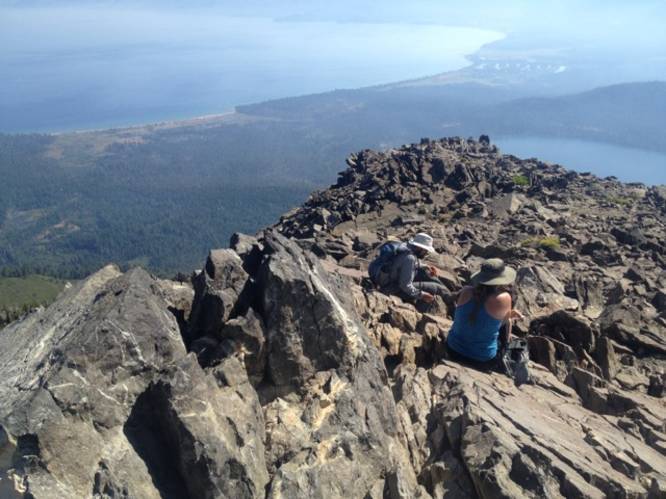
Once at the summit, hikers will get stunning vistas of Gilmore Lake, Lake Tahoe, Fallen Leaf Lake, and more of the Desolation Wilderness. The hike back down is exactly the same as the way up. Trekking poles are helpful when heading back downhill to help spread the weight.
Vistas
Hikers will find plenty of vistas along this trail from views of Lake Tahoe, Fallen Leaf Lake, Gilmore Lake, and the Desolation Wilderness. Hikers do not need to climb to the summit of Mt. Tallac to enjoy views along this hike either, but the views from the top are by far the best.
Permits
Hikers and backpackers will need permits which are self-issued at the trailhead.
Popularity
During the Summer, there are often dozens of people on the summit at once, making this hike a bit overcrowded compared to others. For this reason, starting the hike earlier in the day is the goal for hikers who do not wish to see many people.
Pets
Dogs are allowed if leashed.
For more details, check out the Mount Tallac Norcalhiker blog post
This hike also runs through the Desolation Wilderness which is a part of the Eldorado National Forest. Because of the stunning views of Fallen Leaf Lake, Lake Tahoe, and the Desolation Wilderness, this trail is very popular during warmer months.
The hike begins at the parking lot at the end of Mt. Tallac Road and follows the Mt. Tallac Trail the entire way up the mountain for 4.5-miles one-way. The trail continually climbs the mountain, but the elevation grade near the trailhead is easier than further into the hike.
Hikers will find at approximately 1-mile into the hike, there will be a nice lookout point of Fallen Leaf Lake to the east of the trail. Not long after, at about 1.6-miles into the trek, hikers will pass Floating Island Lake, just west of the trail. Floating Island Lake is much smaller than Fallen Leaf Lake, but still a nice stop along the hike. Note that Floating Island Lake does not have an island in it. Some pre-built campsites can be found on the opposite side of the lake.
After leaving Floating Island Lake, hikers will continue along the Mt. Tallac Trail for another 0.8-miles before reaching Cathedral Lake. From here on out, the trail becomes more strenuous as the elevation grade becomes steeper and the trail starts following switchbacks. From the switcbacks, hikers will find views of Fallen Leaf Lake and Lake Tahoe.
After hiking the switchbacks, the trail passes several junctions before reaching the summit. Hikers will find signage and should stay along the Mt. Tallac Trail to reach the peak. Along the way are views of the Desolation Wilderness, Pyramid Peak, and Ralston Peak.
Once at the summit, hikers will get stunning vistas of Gilmore Lake, Lake Tahoe, Fallen Leaf Lake, and more of the Desolation Wilderness. The hike back down is exactly the same as the way up. Trekking poles are helpful when heading back downhill to help spread the weight.
Vistas
Hikers will find plenty of vistas along this trail from views of Lake Tahoe, Fallen Leaf Lake, Gilmore Lake, and the Desolation Wilderness. Hikers do not need to climb to the summit of Mt. Tallac to enjoy views along this hike either, but the views from the top are by far the best.
Permits
Hikers and backpackers will need permits which are self-issued at the trailhead.
Popularity
During the Summer, there are often dozens of people on the summit at once, making this hike a bit overcrowded compared to others. For this reason, starting the hike earlier in the day is the goal for hikers who do not wish to see many people.
Pets
Dogs are allowed if leashed.
For more details, check out the Mount Tallac Norcalhiker blog post