Miners Castle to Bridalveil Falls at Pictured Rocks National Lakeshore in Munising, Michigan is a moderate 7.4-mile out-and-back hike that features stunning views of the Lake Superior's turquoise water as its juxtaposed alongside sandstone cliffs. This hike features views of Miners Castle, Miners River, Miners Beach, Elliot Falls, and cliffs of the Pictured Rocks from the North Country Trail before turning back at a vista point just beyond the Bridalveil Fall area.
Trails
This hike follows one named trail: North Country Trail / North Country Scenic Trail (NST).
Highly-Trafficked
This is one of the most popular day hike areas at Pictured Rocks National Lakeshore because Miners Castle Overlook is so close to the parking lot. If you show up early, especially middle of the week, you'll have better luck for finding solitude. During peak leaf season, it may be difficult to find solitude here.
Trail Substrate & Universal Access
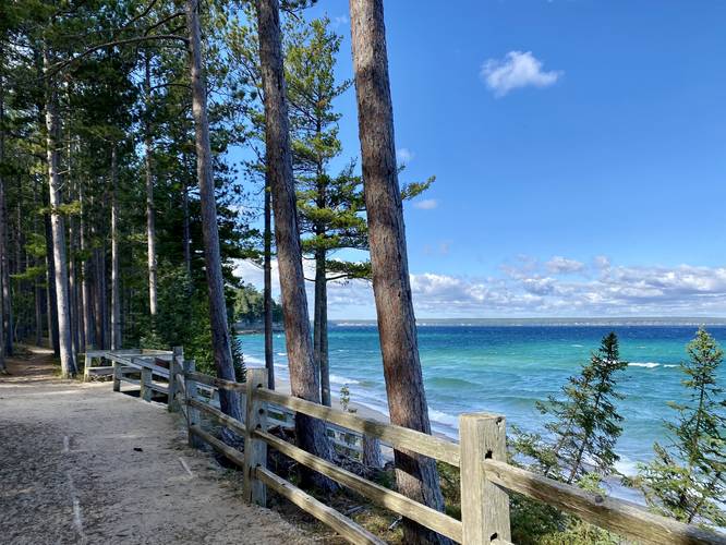
This hike begins along a universally-accessible path that connects to both Miners Castle Overlooks; however, once hikers are on the North Country Trail (NST), this hike is not universally-accessible.
Hike Description
This hike begins at the main parking lot for Miners Castle and passes the main information center along the way. At the wooden information center is where hikers should read the rules before heading on their way.
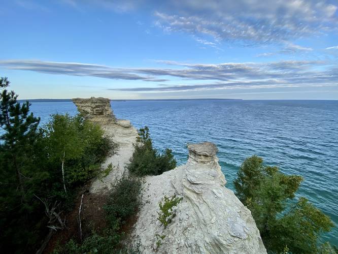
Miners Castle Overlook - Mile 0.06
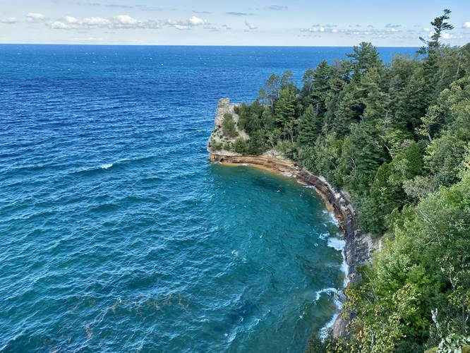
Within just 200-feet from the parking lot lies one of the most scenic spots along the Pictured Rocks National Lakeshore - the Miners Castle Overlook. This overlook is one of the main reasons why people come out here, to view the spectacular turquoise water crash up against the sandstone cliffs, with the jutting rock formation of Miners Castle towering over the water. The time of day and intensity of the sunlight will determine the color variations that visitors see - here and throughout the entire hike's vistas, views, and overlooks.
Miners Castle Lower Overlook - Mile 0.3
After visiting the main overlook for Miners Castle, hikers will head downhill along a paved path as it leads to the lower, up-close, vista for Miners Castle. At mile 0.3 hikers will reach Miners Castle, which provides a less-than-stunning view of the rock formation and the water; however, it's still a nice place to stop and check out Miners Castle in an up-close way before continuing on. Please do not climb the rock formation, there's a serious penalty including a fee and jail time, in addition to potential fatal injuries if you fall off the cliff.
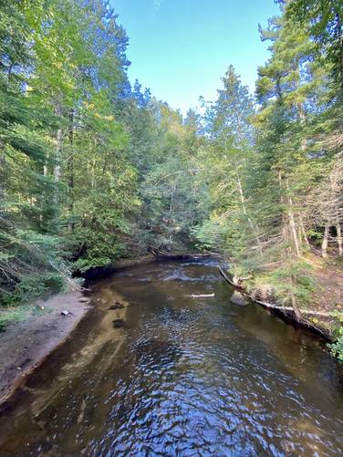
Reaching Miners River - Mile 0.4 to 1.4
Between miles 0.4 and 1.4, hikers will head down a hill with moderate elevation grade for about 150-feet before reaching Miners River. Miners River is oddly scenic - the evergreens sit along sandy banks of the red-tinted water as it slowly flows out to Lake Superior. Along the way is a small footbridge that crosses the river so that hikers don't have to get their feet wet.
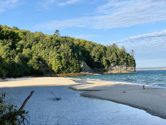
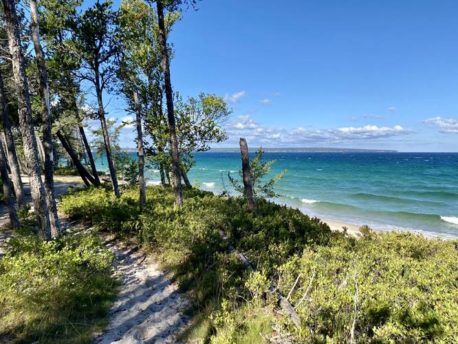
Miners Beach Views - Mile 1.5 to 2.2
Once hikers make it beyond Miners River, there's a nice vista facing west at Miners Beach. From here until mile 2.2, hikers will get awesome views of Lake Superior's turquoise water along Miners Beach with additional views of the distant cliffs of the Pictured Rocks National Lakeshore.
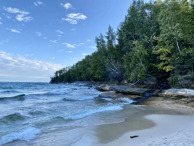
Elliot Falls - Mile 2.26
At mile 2.26, hikers can choose to walk out onto Miners Beach and walk over to where the beach ends on the eastern side. Here is where Elliot Falls spills into Lake Superior. Elliot Falls is a seasonal cascade that flows down sloping bedrock and is not very tall - maybe 10-feet at most.
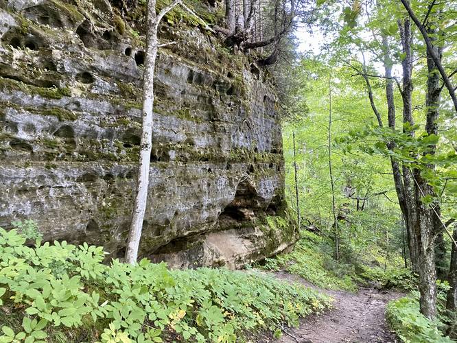
Holey Cliff - Mile 2.5
After passing the Miners Beach / Elliot Falls area, the trail will lead into a parking lot for Miners Beach before heading back up a ~100-foot hill climb. Along this walk back uphill is a large cliff face with countless holes and carvings, likely from water erosion thousands of years ago. The cliff is about 40-feet tall and over 100-feet long and makes for an impressive sight along the trail.
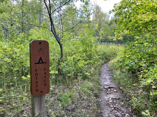
Potato Patch Campsite - Mile 2.56
At mile 2.56, hikers will reach the spur trail that leads to the campsites named "Potato Patch". Please note that all camping here requires a backcountry permit.
Upper Elliot Falls - Mile 2.58
Just beyond Potato Patch, or maybe just to the north of the sign, lies the upper cascade for the seasonally-flowing Elliot Falls. It's far too dangerous to attempt to photograph the cliff that the water flows off of, hence the low-quality photo provided.
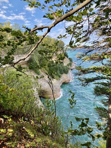
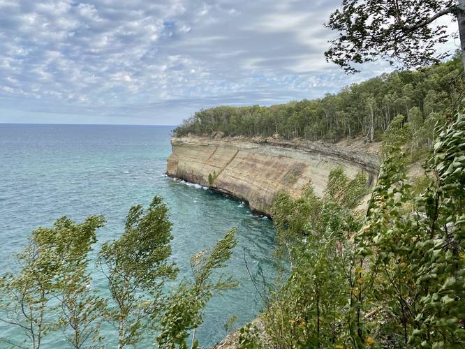
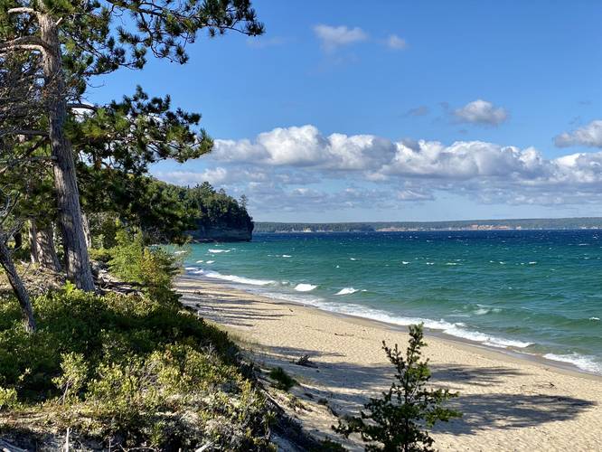
Pictured Rocks Vista - Mile 2.35
After passing Potato Patch and Upper Elliot Falls, the hike becomes a quiet woods walk for a little while as you hike toward the Bridalveil Falls area. Along the way, hikers will pass a stunning vista, facing west, of the Pictured Rocks coastline. There are a couple of vantage points here, but the vista is well-worth the stop.
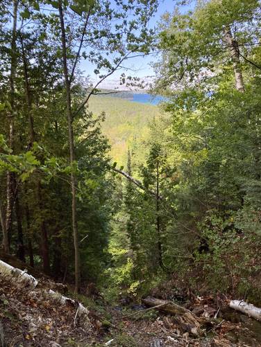
Bridalveil Falls Creek - Mile 3.44
Around mile 3.44, hikers will reach the seasonally-flowing creek that flows north and forms Bridalveil Falls as it cascades down the Pictured Rocks cliffs into Lake Superior. During September 2022, this creek was completely dried up, so we decided to stay on-trail and not follow the creek to the top of the waterfall.
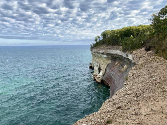
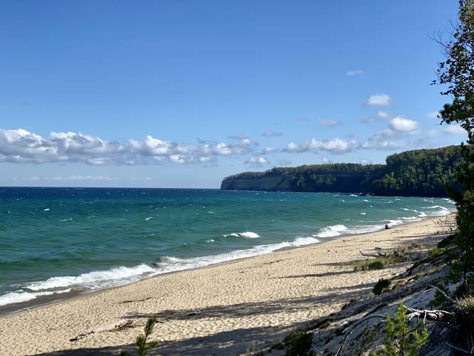
Pictured Rocks Vista - Mile 3.58
After passing the creek, hikers will find another view of the Pictured Rocks cliffs around mile 3.58, which is worth the stop. During our trip in September 2022, the rocks looked as if they were "bleeding" water from the top, which caused a dark staining to appear on the cliffs, making for an interesting landscape alongside the turquoise waters of Lake Superior.
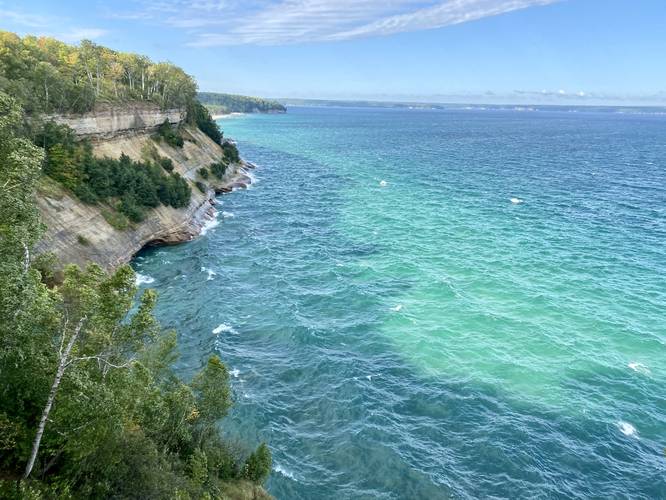
Pictured Rocks Vista / Turnaround - Mile 3.83
The last stop on this short day hike is the last vista of the Pictured Rocks cliffs, located around mile 3.83. This vista has more open views than the last, making it a nice place to turn around for a day hike that's under 8-miles out-and-back.
Hiking Out - Mile 3.83 to 7.24
The hike out obviously follows the opposite hike in; however, there are some things to note. The total distance of the hike out is usually shorter than the hike in since you won't be stopping at all of the vista points and other points-of-interest. Additionally, if this is your last hike along the Pictured Rocks coastline, take in everything you can on your way out, especially when hiking past the first Pictured Rocks vista and along Miners Beach. The hill climb at the end isn't the worst, but it's elevation grade makes this hike "moderate" instead of "easy".
Parking & Fees
Hikers will find a very large parking lot at the coordinates provided which is large enough to fit several dozen vehicles. Please note that there's a fee of about $10 as of September 2022 to park. The park takes fees via an online checkout system and cell service (Verizon) as of September 2022 was spotty at the trailhead, thus made it impossible to pay. When we arrived, at ~8AM, we were the second vehicle in the lot and no one was around to take cash. Knowing this now, it's best to pre-pay for parking before you show up. If you forget to pre-pay, please remember to pay afterward since the funds go toward the national park system to keep Pictured Rocks National Lakeshore open and available to everyone.
Pets
Dogs are not allowed, please leave your furry friend at home.
Warnings
Cliffs: This hike follows areas where beautiful vistas sit atop very steep and dangerous cliffs. Soil can sometimes break free, which could accidentally send a hiker down the cliffs causing serious injury if not death. It's best to enjoy the views of the Pictured Rocks coastline from a further back from the cliff's edge just in case.
Bridalveil Falls - No View: First, Bridalveil Falls is seasonal and second, the waterfall is mostly visible from a boat. If you plan to follow the creek to the top of Bridalveil Falls, it's best to keep back from the cliff's overhanging edge, as you never know when it may break away in the future.
Wind and Sand: Surprisingly, there's a lot of sand that gets kicked up in the wind along this hike. Since Lake Superior can get very windy, the sand ends up whipping past your face, can get into your eyes, and ends up embedding itself in your hair as it works its way onto your scalp. Not much you can do, but it's good to note.
Trails
This hike follows one named trail: North Country Trail / North Country Scenic Trail (NST).
Highly-Trafficked
This is one of the most popular day hike areas at Pictured Rocks National Lakeshore because Miners Castle Overlook is so close to the parking lot. If you show up early, especially middle of the week, you'll have better luck for finding solitude. During peak leaf season, it may be difficult to find solitude here.
Trail Substrate & Universal Access
This hike begins along a universally-accessible path that connects to both Miners Castle Overlooks; however, once hikers are on the North Country Trail (NST), this hike is not universally-accessible.
Hike Description
This hike begins at the main parking lot for Miners Castle and passes the main information center along the way. At the wooden information center is where hikers should read the rules before heading on their way.
Miners Castle Overlook - Mile 0.06
Within just 200-feet from the parking lot lies one of the most scenic spots along the Pictured Rocks National Lakeshore - the Miners Castle Overlook. This overlook is one of the main reasons why people come out here, to view the spectacular turquoise water crash up against the sandstone cliffs, with the jutting rock formation of Miners Castle towering over the water. The time of day and intensity of the sunlight will determine the color variations that visitors see - here and throughout the entire hike's vistas, views, and overlooks.
Miners Castle Lower Overlook - Mile 0.3
After visiting the main overlook for Miners Castle, hikers will head downhill along a paved path as it leads to the lower, up-close, vista for Miners Castle. At mile 0.3 hikers will reach Miners Castle, which provides a less-than-stunning view of the rock formation and the water; however, it's still a nice place to stop and check out Miners Castle in an up-close way before continuing on. Please do not climb the rock formation, there's a serious penalty including a fee and jail time, in addition to potential fatal injuries if you fall off the cliff.
Reaching Miners River - Mile 0.4 to 1.4
Between miles 0.4 and 1.4, hikers will head down a hill with moderate elevation grade for about 150-feet before reaching Miners River. Miners River is oddly scenic - the evergreens sit along sandy banks of the red-tinted water as it slowly flows out to Lake Superior. Along the way is a small footbridge that crosses the river so that hikers don't have to get their feet wet.
Miners Beach Views - Mile 1.5 to 2.2
Once hikers make it beyond Miners River, there's a nice vista facing west at Miners Beach. From here until mile 2.2, hikers will get awesome views of Lake Superior's turquoise water along Miners Beach with additional views of the distant cliffs of the Pictured Rocks National Lakeshore.
Elliot Falls - Mile 2.26
At mile 2.26, hikers can choose to walk out onto Miners Beach and walk over to where the beach ends on the eastern side. Here is where Elliot Falls spills into Lake Superior. Elliot Falls is a seasonal cascade that flows down sloping bedrock and is not very tall - maybe 10-feet at most.
Holey Cliff - Mile 2.5
After passing the Miners Beach / Elliot Falls area, the trail will lead into a parking lot for Miners Beach before heading back up a ~100-foot hill climb. Along this walk back uphill is a large cliff face with countless holes and carvings, likely from water erosion thousands of years ago. The cliff is about 40-feet tall and over 100-feet long and makes for an impressive sight along the trail.
Potato Patch Campsite - Mile 2.56
At mile 2.56, hikers will reach the spur trail that leads to the campsites named "Potato Patch". Please note that all camping here requires a backcountry permit.
Upper Elliot Falls - Mile 2.58
Just beyond Potato Patch, or maybe just to the north of the sign, lies the upper cascade for the seasonally-flowing Elliot Falls. It's far too dangerous to attempt to photograph the cliff that the water flows off of, hence the low-quality photo provided.
Pictured Rocks Vista - Mile 2.35
After passing Potato Patch and Upper Elliot Falls, the hike becomes a quiet woods walk for a little while as you hike toward the Bridalveil Falls area. Along the way, hikers will pass a stunning vista, facing west, of the Pictured Rocks coastline. There are a couple of vantage points here, but the vista is well-worth the stop.
Bridalveil Falls Creek - Mile 3.44
Around mile 3.44, hikers will reach the seasonally-flowing creek that flows north and forms Bridalveil Falls as it cascades down the Pictured Rocks cliffs into Lake Superior. During September 2022, this creek was completely dried up, so we decided to stay on-trail and not follow the creek to the top of the waterfall.
Pictured Rocks Vista - Mile 3.58
After passing the creek, hikers will find another view of the Pictured Rocks cliffs around mile 3.58, which is worth the stop. During our trip in September 2022, the rocks looked as if they were "bleeding" water from the top, which caused a dark staining to appear on the cliffs, making for an interesting landscape alongside the turquoise waters of Lake Superior.
Pictured Rocks Vista / Turnaround - Mile 3.83
The last stop on this short day hike is the last vista of the Pictured Rocks cliffs, located around mile 3.83. This vista has more open views than the last, making it a nice place to turn around for a day hike that's under 8-miles out-and-back.
Hiking Out - Mile 3.83 to 7.24
The hike out obviously follows the opposite hike in; however, there are some things to note. The total distance of the hike out is usually shorter than the hike in since you won't be stopping at all of the vista points and other points-of-interest. Additionally, if this is your last hike along the Pictured Rocks coastline, take in everything you can on your way out, especially when hiking past the first Pictured Rocks vista and along Miners Beach. The hill climb at the end isn't the worst, but it's elevation grade makes this hike "moderate" instead of "easy".
Parking & Fees
Hikers will find a very large parking lot at the coordinates provided which is large enough to fit several dozen vehicles. Please note that there's a fee of about $10 as of September 2022 to park. The park takes fees via an online checkout system and cell service (Verizon) as of September 2022 was spotty at the trailhead, thus made it impossible to pay. When we arrived, at ~8AM, we were the second vehicle in the lot and no one was around to take cash. Knowing this now, it's best to pre-pay for parking before you show up. If you forget to pre-pay, please remember to pay afterward since the funds go toward the national park system to keep Pictured Rocks National Lakeshore open and available to everyone.
Pets
Dogs are not allowed, please leave your furry friend at home.
Warnings
Cliffs: This hike follows areas where beautiful vistas sit atop very steep and dangerous cliffs. Soil can sometimes break free, which could accidentally send a hiker down the cliffs causing serious injury if not death. It's best to enjoy the views of the Pictured Rocks coastline from a further back from the cliff's edge just in case.
Bridalveil Falls - No View: First, Bridalveil Falls is seasonal and second, the waterfall is mostly visible from a boat. If you plan to follow the creek to the top of Bridalveil Falls, it's best to keep back from the cliff's overhanging edge, as you never know when it may break away in the future.
Wind and Sand: Surprisingly, there's a lot of sand that gets kicked up in the wind along this hike. Since Lake Superior can get very windy, the sand ends up whipping past your face, can get into your eyes, and ends up embedding itself in your hair as it works its way onto your scalp. Not much you can do, but it's good to note.