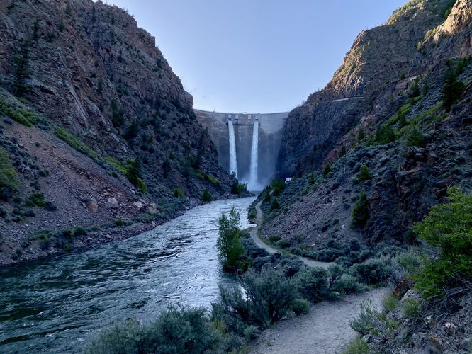
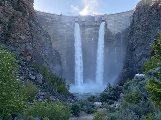
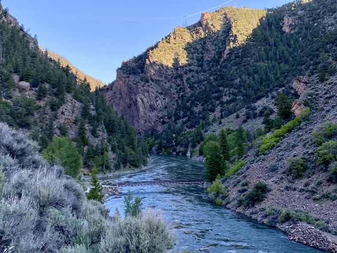
The Mesa Creek Trail & Morrow Point Dam Overlook at Curecanti National Recreation Area in Cimarron, Colorado is a moderate 0.8-mile loop hike that features views of the Gunnison River from the floor of the gorge in addition to the 350-foot human-made waterfall known as the Morrow Point Dam.
Hike
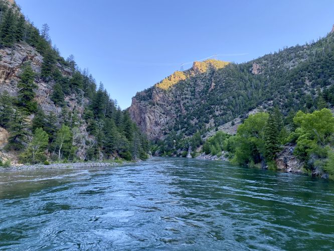
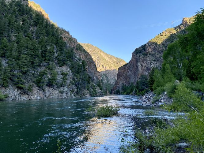
This short hike begins at the main parking lot at Morrow Point Dam and leads down the Mesa Creek Trail. The Mesa Creek Trail quickly leads downhill, following adjacent to the Cimarron River. The trail then reaches a junction with a bridge that spans the Gunnison River and a pathway that leads toward Morrow Point Dam. This route explores the Mesa Creek Trail further and crosses the footbridge first. The footbridge spans the entire width of the Gunnison River which provides beautiful views of the river, the Black Canyon gorge downstream, and the Morrow Point Dam with its 350-foot waterfall to the east. The trail then undulates along the northern banks of the Gunnison River, passing a plethora of poison ivy located just off-trail. From the Mesa Creek Trail, hikers will find more views that peer westward into the "beginning" sections of the Black Canyon. During our hike here in early-morning early June 2024, we planned to hike the entire length of the Mesa Creek Trail, but due to unexpected freezing ~37 degree (F) morning temperatures, whipping wind, and tons of poison ivy, we decided to cut our losses and turn back. In doing so, we crossed the bridge and hiked the universally-accessible grade trail back up to parking. Along this easier-grade trail, you'll find beautiful views of the 350-foot human-made cascades that plunge from the massive dam along the Gunnison River. Once at the top, near parking, you'll find plenty of information kiosks about the Morrow Point Dam, its construction, and the river.
Universal Access
Note that only a portion of this trail is universally-accessible -- notably the "end" of the route provided which is the section of trail from the parking lot heading east toward the Morrow Point Dam and down to the footbridge. That pathway follows concrete / paved surfaces before following an easy grade downhill along crushed gravel to reach the footbridge. The Mesa Creek Trail portion of this route is not accessible.
Warning
Fast-moving water: The fast-moving waters of the Gunnison River can be extremely dangerous. This trail runs along some steep slopes near the water's edge, so watch your step and always pay attention to where you're headed. Do not attempt to swim in the river as it could lead to drowning via flash flooding from the dam upstream or rapids downstream.
Poison ivy: On this hike in June 2024, we found a plethora of poison ivy on the Mesa Creek Trail as it ran along the northern banks of the Gunnison River. Watch your step and remember to watch your hands with cold soapy water after untying your boots.
Falling rocks: This trail runs through a canyon valley where sometimes rockfall occurs. While rare, this can happen randomly and without warning.
Flash floods: The dam upstream, with its ~350-foot waterfall, can increase water levels in the river without warning. You must be careful hiking the Mesa Creek Trail as the river's height might change rapidly. If so, you must find high ground immediately to avoid serious repercussions.
Hike
This short hike begins at the main parking lot at Morrow Point Dam and leads down the Mesa Creek Trail. The Mesa Creek Trail quickly leads downhill, following adjacent to the Cimarron River. The trail then reaches a junction with a bridge that spans the Gunnison River and a pathway that leads toward Morrow Point Dam. This route explores the Mesa Creek Trail further and crosses the footbridge first. The footbridge spans the entire width of the Gunnison River which provides beautiful views of the river, the Black Canyon gorge downstream, and the Morrow Point Dam with its 350-foot waterfall to the east. The trail then undulates along the northern banks of the Gunnison River, passing a plethora of poison ivy located just off-trail. From the Mesa Creek Trail, hikers will find more views that peer westward into the "beginning" sections of the Black Canyon. During our hike here in early-morning early June 2024, we planned to hike the entire length of the Mesa Creek Trail, but due to unexpected freezing ~37 degree (F) morning temperatures, whipping wind, and tons of poison ivy, we decided to cut our losses and turn back. In doing so, we crossed the bridge and hiked the universally-accessible grade trail back up to parking. Along this easier-grade trail, you'll find beautiful views of the 350-foot human-made cascades that plunge from the massive dam along the Gunnison River. Once at the top, near parking, you'll find plenty of information kiosks about the Morrow Point Dam, its construction, and the river.
Universal Access
Note that only a portion of this trail is universally-accessible -- notably the "end" of the route provided which is the section of trail from the parking lot heading east toward the Morrow Point Dam and down to the footbridge. That pathway follows concrete / paved surfaces before following an easy grade downhill along crushed gravel to reach the footbridge. The Mesa Creek Trail portion of this route is not accessible.
Warning
Fast-moving water: The fast-moving waters of the Gunnison River can be extremely dangerous. This trail runs along some steep slopes near the water's edge, so watch your step and always pay attention to where you're headed. Do not attempt to swim in the river as it could lead to drowning via flash flooding from the dam upstream or rapids downstream.
Poison ivy: On this hike in June 2024, we found a plethora of poison ivy on the Mesa Creek Trail as it ran along the northern banks of the Gunnison River. Watch your step and remember to watch your hands with cold soapy water after untying your boots.
Falling rocks: This trail runs through a canyon valley where sometimes rockfall occurs. While rare, this can happen randomly and without warning.
Flash floods: The dam upstream, with its ~350-foot waterfall, can increase water levels in the river without warning. You must be careful hiking the Mesa Creek Trail as the river's height might change rapidly. If so, you must find high ground immediately to avoid serious repercussions.