The McIntire - Sands - Gage Loop at Elizabeth Burns McIntire Forest in Marlow, New Hampshire is a moderate 2.1-mile loop hike that summits Bald Hill, featuring views from its southern slopes, and leads to the Marlow Climbing Crag.
Trail names: Sands Trail, McIntire Trail, Gage Trail (aka Village Loop Trail)
Location: Elizabeth Burns McIntire Forest, Route 123 Forest Road Marlow, NH
Permitted uses: Hiking, Biking, Rock Climbing, Cross Country Skiing, Horseback riding on the Village Loop Trail, Hunting, Blueberry picking, Birdwatching, Nature Study, Geocaching
Prohibited uses: No Fires, No overnight Camping, No Vehicles on Foot trails
Hours: There are no posted hours
Fees and Parking: There is no fee to park or use the trails. Parking is limited at the trailhead.
Pets: Dogs are allowed on the trail, but must be leashed to protect wildlife. Please leave no trace and do not leave bagged dog waste along the trail.
Accessibility: This hike is not wheelchair accessible.
Hiker amenities: There is an information kiosk at the trailhead. There are no trash bins, please carry out what you carry in. There are no restrooms.
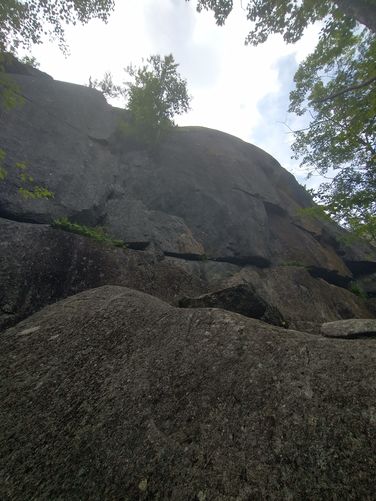
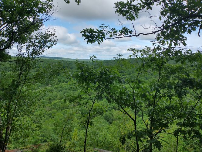
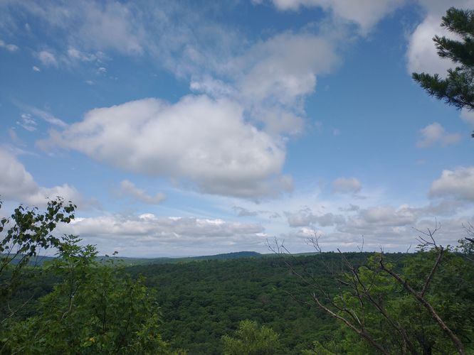
Length and Trail information: This hike was done as a loop and is considered moderately hard. Our hike was 2.1 miles in length and included three trails. The first trail we accessed was the Sands Trail. It has a yellow blaze and the trail substrate is very rooted, rocky and steep. Besides the yellow markers, hikers will occasionally see engraved wooden signs with the trail name painted in the color of the blaze. The trail has a pretty good incline that starts fairly early into the hike. There are lots of rocks to navigate as you climb and this is most likely why this trail is considered moderately hard. Part way up the trail there is a massive rock outcropping known locally as the “Marlow climbing crag”. Don't forget to stop during your ascent to enjoy the view of the valley below. Near the summit of Bald Hill, hikers will pass a very large cairn. Not too much further past the cairn, hikers will find a surprisingly fun place to stop. This spot appears to be a Rock lounge chair area. Someone has crafted several stone chairs around a rock fire pit and it’s an excellent place to have a snack and rest for a bit. It looks as if previous visitors have had fires, but fires are prohibited in this forest. After our rest we began our descent down Sands trail through the forest. The descent is rocky and a little slippery due to the build up of fallen leaves.
From the Sands trail, we connected to the McIntire Trail. The McIntire Trail is marked by a white diamond blaze and an occasional engraved sign with its name painted white. The terrain on this trail is narrow and typical of a woodland trail, however this trail was much less rocky than the Sands trail. We also found that the ascents and descents on this trail were much less drastic than the Sands Trail and had we just hiked the McIntire trail, we would very likely have classified it as easy. Instead of being rocky, the McIntire trail seems to have more flora and is wetter than Sands Trail, allowing for hikers to see vast swaths of ferns growing on either side of the trail along with a lot of low bush blueberries full of ripe fruit. A word to the wise, plan for some extra time and bring a few containers if you decide to hike here during blueberry season. From the McIntire Trail we moved onto the Gage Trail. The Gage Trail is marked by orange blazes and occasional engraved signs with the name of the trail painted orange. A word of caution, the Gage trail markers are sometimes very hard to see painted on the trees, so take your time and carefully look for them, they often seem to blend in. We also noted other trail markers on this trail that hinted at snow mobile use although we did not find any information about using this area for that purpose. We also saw Blue diamond markers that said this was “The Village Loop Trail”. So apparently these trails overlap for a time. We did notice a sign on the trail that warned of a trail junction ahead, and it was needed as the Gage Trail was very grassy and could have been missed. The terrain on the Gage trail is much like a class 6 roadway. It’s wide and flat and allows for easy walking. If a hiker were to hike just the Gage Trail as an “out an back” hike from the trailhead, this would definitely be an easy hike,but still not wheelchair accessible. There is a grassy swampy area at the trail's end/start that will require you to do a tick check after passing through.
This was a great hike. It offered some fun rocky climbs, a nice view, quirky features like the rock chair lounge area,. It offered shaded well maintained trails and an abundance of blueberries. A great way to spend a summer morning.