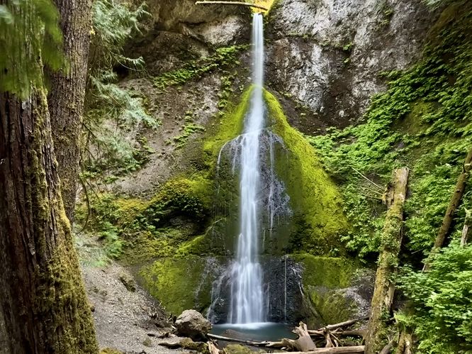
The Marymere Falls Trail at Olympic National Park near Piedmont, Washington is a moderate 1.9-mile out-and-back hike that leads to the 90-foot tall free-fall waterfall, Marymere Falls.
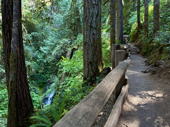
On the other side of the highway, the Marymere Falls Trail heads through the lush forest full of vibrant moss-covered trees, ferns, and hanging mosses. You'll find several large trees with gnarled roots along the way which provide interesting photo opportunities, as long as the sunlight isn't too harsh.
Just beyond the old-growth is a wide metal footbridge that arches over Barnes Creek where you'll find scenic views of the water and the lush rainforest-like vegetation growing along its banks.
Steep terrain: This trail follows a moderate grade up to reach the waterfall, however, some hikers may find the steepness "hard" instead of "moderate". Additionally, the terrain located just beyond the trail's fence along Falls Creek is extremely steep and dangerous. Stay on-trail at all times to ensure your own safety.
Not for strollers: While parents might want to bring their young kids to Marymere Falls, before you plan to attempt to push a stroller to the waterfall, you'll find that this is virtually impossible. Once you pass the Barnes Creek bridge, you're faced with a very-skinny footbridge at Falls Creek. Then you're faced with a steep uphill hike that follows both stairs and a root-filled path. Neither the footbridge nor the loop trail are suitable for strollers. If your child needs a stroller most of the time, then this hike is likely not for you.
Hike to Marymere Falls
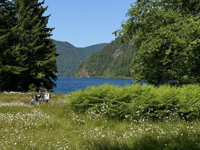
This hike begins at the Storm King Ranger Station where hikers will find signage that points the way for Marymere Falls. Simply follow the main path as it leads east toward Lake Crescent. On the way, you'll find a beautiful open meadow with views of the lake as it passes the ranger station. The trail then curves to the south as it passes through a tunnel under the Olympic Highway.On the other side of the highway, the Marymere Falls Trail heads through the lush forest full of vibrant moss-covered trees, ferns, and hanging mosses. You'll find several large trees with gnarled roots along the way which provide interesting photo opportunities, as long as the sunlight isn't too harsh.
Old-Growth Tree - Mile 0.72
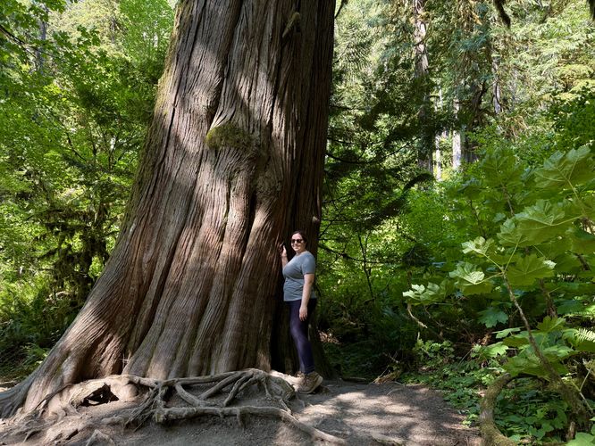
Around mile 0.72, hikers will approach the first footbridge that spans Barnes Creek, but just before it is a massive old-growth tree that's worthy of another photo-op. This ancient tree towers over the forest and simply cannot be missed, unless you're staring at your feet for the entire hike.Just beyond the old-growth is a wide metal footbridge that arches over Barnes Creek where you'll find scenic views of the water and the lush rainforest-like vegetation growing along its banks.
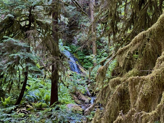
Footbridge & Lower Marymere Falls - Mile 0.78
Just beyond the Barnes Creek footbridge is a wooden, single-file footbridge that spans Falls Creek. Here, you may need to wait for streams of hikers from the other side or you may get lucky to find there's no traffic jam at the bridge. Either way, you'll need to cross here, but if you look upstream, you'll notice a beautiful view of Lower Marymere Falls.Marymere Falls - Mile 0.9
After crossing the Falls Creek footbridge, the trail leads uphill along a moderate to steep grade to reach the 90-foot tall Marymere Falls. After following the initial set of stairs uphill, this route takes a left-hand turn at the loop to follow along Falls Creek as the trail ascends higher. Along the way, you'll find an obstructed view of Middle Marymere Falls as it cascades down the bedrock. Not far from here, the trail curves around an old-growth tree with a portrait view of Marymere Falls and just beyond this curve is an overlook where you'll find the stunning 90-foot tall waterfall spilling over its moss-covered cliff. The view of Marymere Falls from this overlook is unmatched, so plan to enjoy the best views of the waterfall from here. Take your photos, videos, and cram-in more memories before you continue hiking as the overlook is a popular destination for hikers to simply hang out for a while before they continue.Marymere Falls Upper Viewpoint - Mile 0.92
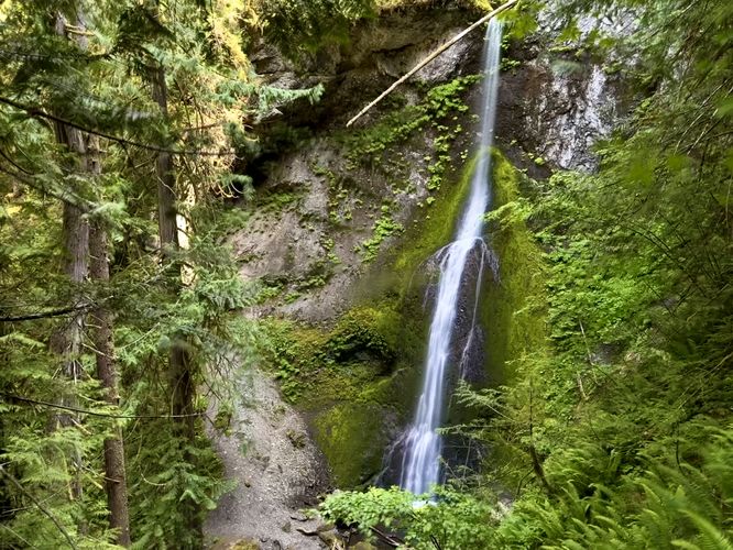
After exploring the lower overlook at the base of Marymere Falls, the trail continues onward to complete the loop, but along the way is one last overlook of the waterfall. Follow the steep staircase as it leads uphill to reach the upper viewpoint for Marymere Falls around mile 0.92. This overlook platform isn't nearly as nice as the lower viewpoint, but you still get awesome views of the 90-foot tall waterfall and its moss-covered cliff.Hiking Out - Mile 0.92 to 1.9
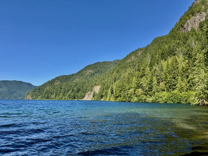
After exploring the upper viewpoint for Marymere Falls, the best points-of-interest along this hike are essentially over with the exception of the views and old-growth trees you found on the way in. You'll hike down the steep sets of stairs along the short loop trail before crossing the Falls Creek and Barnes Creek footbridges. Pass the old-growth tree and enjoy the forest's lush vegetation as you make your way back toward parking. For one last stop on your way out, consider hiking off-trail to reach the shores of Lake Crescent where you can enjoy the lake's turquoise-tinted waters near its shoreline and the surrounding mountains that tower overhead. Follow the trail past the ranger station to reach the parking area where the hike wraps up at 1.9-miles out-and-back.Parking
Hikers will find a large parking lot at the coordinates provided, located near the Storm King Ranger Station at the park. The lot is large enough to fit over two dozen vehicles as of June 2025, but due to popularity with this hike and others in the area you may find that the parking lot is full. If so, many people park just off of the road within this area of the park where off-road parking is permitted. Park at your own risk if the parking lot is full.Pets
Dogs are not allowed on this trail per park rules as of June 2025.Warning
Cougars: This area is home to the cougar / mountain lion. Cougars like forests with thick brush and canyons, so the Falls Creek ravine is a perfect home for them. While this trail is popular and cougars will likely be extremely rare to be found here, it's best to hike in groups and make noise while you're hiking to ensure you scare off any hiding mountain lions. Cougar attacks on humans in Washington is extremely rare, but it's good to be mindful of their possible presence.Steep terrain: This trail follows a moderate grade up to reach the waterfall, however, some hikers may find the steepness "hard" instead of "moderate". Additionally, the terrain located just beyond the trail's fence along Falls Creek is extremely steep and dangerous. Stay on-trail at all times to ensure your own safety.
Not for strollers: While parents might want to bring their young kids to Marymere Falls, before you plan to attempt to push a stroller to the waterfall, you'll find that this is virtually impossible. Once you pass the Barnes Creek bridge, you're faced with a very-skinny footbridge at Falls Creek. Then you're faced with a steep uphill hike that follows both stairs and a root-filled path. Neither the footbridge nor the loop trail are suitable for strollers. If your child needs a stroller most of the time, then this hike is likely not for you.