The Makauwahi Cave Trail at the Makauwahi Cave Reserve in Koloa, Hawaii (Kauai) is a moderate 0.9-mile loop trail that leads to the Makauwahi Cave, including a hike around the upper rim of the cave's sinkhole.
Hike Description
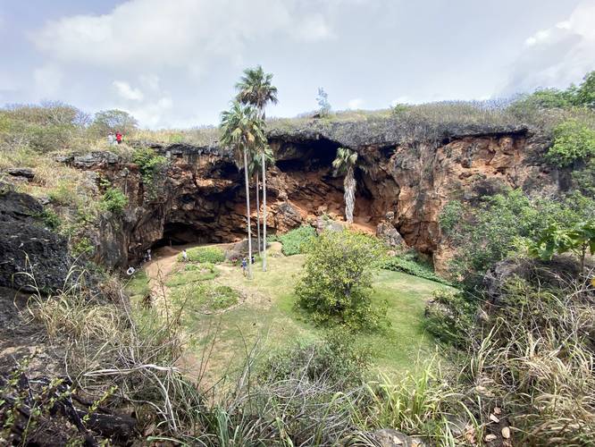
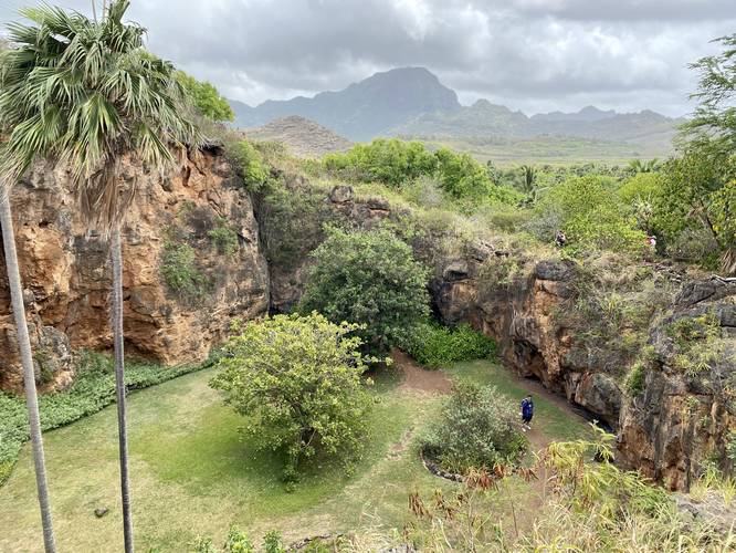
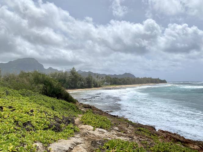
This trail begins at the dead end road just east of the Grand Hyatt golf course adjacent to the CJM Country Stables. The trail leads in along a sandy path, passing self-guided numbered markers along the route. Around mile 0.3, the trail will reach a view of the Makauwahi Cave, sinkhole, and the surrounding mountains in the background from the cave's upper rim. The trail then leads down a narrow and slightly-steep trail as it begins to circle the rim above the cave. We followed this trail out to the south side of the cave's rim, giving a nice view down into the Makauwahi Cave, before then heading downhill along the trail as it makes its way to the cave entrance.
Trail Split - Mile 0.35
Around mile 0.35, hikers will find a split in the trail as you head downhill toward Waiopili Stream and Maha'ulepu Beach / Gillin's Beach. Keeping left will lead to the Makauwahi Cave entrance - keeping right will head to Maha'ulepu Beach / Gillin's Beach and the Makawehi Bluffs. By keeping left at the junction, the trail will run alongside the Waiopili Stream, where salt and fresh water meet. There's a small footbridge here that leads over to the Maha'ulepu Beach / Gillin's Beach parking lot.
Entering Makauwahi Cave - Mile 0.4
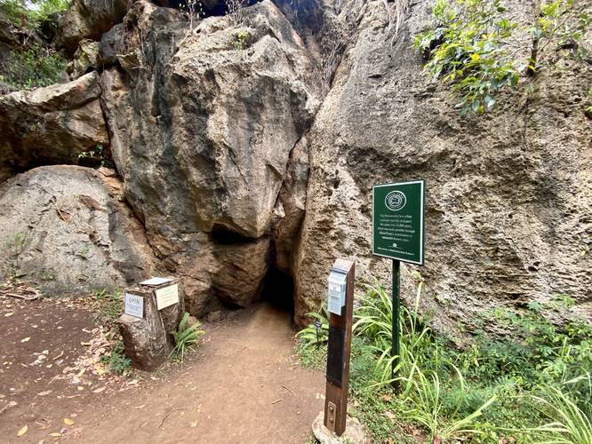
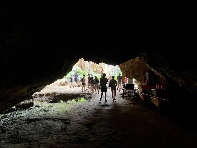
At mile 0.4, hikers will reach the entrance to Makauwahi Cave. The entrance is technically a crawlspace, requiring hikers to get on their hands and knees, as they pass through a triangular-shaped hole in the lava rock. This entrance notch is located on the ground and is approximately 2-feet tall by 2-feet wide with a metal gate in the lava rock that's used to close-off the cave. On the other side of this crawlspace entrance, approximately 3-feet beyond the entrance, the first section of cave opens up to the hiker. While it's not a massive cave, the Makauwahi Cave first greets visitors by placing them directly into the back of a cave, where the entrance door leads to. Walking beyond the cave, hikers will enter the wide open 80-foot tall cliff walls that lead to a large sinkhole area. Once in the sinkhole of the cave, hikers can walk around to explore different plants, fossils, and even cave insects like the Blind Cave Spider. In the back of the sinkhole is yet another cave, which is approximately 50-feet deep (horizontally) where hikers can explore.
Hiking Out
After exploring the Makauwahi Cave and its sinkhole, hikers may want to explore the Makawehi Bluffs portion of the area before heading back to parking. Head back to the split to Maha'ulepu Beach / Gillin's Beach and follow the stream to the ocean. Once at the ocean, keep right (do not cross the stream) to head up onto the bluffs. Along the Makawehi Bluffs, hikers will get a view of Mt. Haupu which is the highest point on the south part of Kauai. The views also include Maha'ulepu Beach / Gillin's Beach with turquoise waves crashing ashore. Eventually, this sandy path will reach more signage for the Makauwahi Cave Trail - follow the opposite arrows to get back to the parking lot.
Hours
The cave and the property's trails are open from 10AM - 6PM every day.
Parking
Hikers will find parking at the coordinates provided at the end of a dead end road.
Pets
Dogs are allowed on this trail, but they must be kept on a leash at all times and their waste should be carried out by the hiker. Dogs are not allowed in the cave itself, so they must be left outside of the crawlspace entrance.
Warning
Stay on trail: While one may be tempted to go off-trail here, the trail leads over a cave system above the Makauwahi Cave. Apparently there are hidden holes that are large enough for a person to fall into. Additionally, one side of the rim portion of the trail leads to an 80-foot tall cliff that sits above the sink hole.
Native and rare plants: Many rare species have been planted in and around the Makauwahi Cave to help preserve species that are difficult to find in dry lowland Hawaiian forests. By staying on the trail, and not touching the plants, these rare species can continue to thrive.
No water: There's no potable water along this trail and unless in the cave, hikers are mostly exposed to the sun.
Private Property
While this is a free space for the public to explore, the Makauwahi Cave is located on private property. The folks who run the cave ask for donations to keep the cave preservation running and to likely pay for insurance for the public to continue to enjoy and explore this rare ecosystem. Please respect all of the park rules.
Respecting the Land
Hawaiian land is considered sacred to native Hawaiians and many locals, so please stay on-trail, take nothing but photos, and leave nothing but footprints. Respect the locals - don't stay for long and have a backup hike planned in case the parking lot is full.
Hike Description
This trail begins at the dead end road just east of the Grand Hyatt golf course adjacent to the CJM Country Stables. The trail leads in along a sandy path, passing self-guided numbered markers along the route. Around mile 0.3, the trail will reach a view of the Makauwahi Cave, sinkhole, and the surrounding mountains in the background from the cave's upper rim. The trail then leads down a narrow and slightly-steep trail as it begins to circle the rim above the cave. We followed this trail out to the south side of the cave's rim, giving a nice view down into the Makauwahi Cave, before then heading downhill along the trail as it makes its way to the cave entrance.
Trail Split - Mile 0.35
Around mile 0.35, hikers will find a split in the trail as you head downhill toward Waiopili Stream and Maha'ulepu Beach / Gillin's Beach. Keeping left will lead to the Makauwahi Cave entrance - keeping right will head to Maha'ulepu Beach / Gillin's Beach and the Makawehi Bluffs. By keeping left at the junction, the trail will run alongside the Waiopili Stream, where salt and fresh water meet. There's a small footbridge here that leads over to the Maha'ulepu Beach / Gillin's Beach parking lot.
Entering Makauwahi Cave - Mile 0.4
At mile 0.4, hikers will reach the entrance to Makauwahi Cave. The entrance is technically a crawlspace, requiring hikers to get on their hands and knees, as they pass through a triangular-shaped hole in the lava rock. This entrance notch is located on the ground and is approximately 2-feet tall by 2-feet wide with a metal gate in the lava rock that's used to close-off the cave. On the other side of this crawlspace entrance, approximately 3-feet beyond the entrance, the first section of cave opens up to the hiker. While it's not a massive cave, the Makauwahi Cave first greets visitors by placing them directly into the back of a cave, where the entrance door leads to. Walking beyond the cave, hikers will enter the wide open 80-foot tall cliff walls that lead to a large sinkhole area. Once in the sinkhole of the cave, hikers can walk around to explore different plants, fossils, and even cave insects like the Blind Cave Spider. In the back of the sinkhole is yet another cave, which is approximately 50-feet deep (horizontally) where hikers can explore.
Hiking Out
After exploring the Makauwahi Cave and its sinkhole, hikers may want to explore the Makawehi Bluffs portion of the area before heading back to parking. Head back to the split to Maha'ulepu Beach / Gillin's Beach and follow the stream to the ocean. Once at the ocean, keep right (do not cross the stream) to head up onto the bluffs. Along the Makawehi Bluffs, hikers will get a view of Mt. Haupu which is the highest point on the south part of Kauai. The views also include Maha'ulepu Beach / Gillin's Beach with turquoise waves crashing ashore. Eventually, this sandy path will reach more signage for the Makauwahi Cave Trail - follow the opposite arrows to get back to the parking lot.
Hours
The cave and the property's trails are open from 10AM - 6PM every day.
Parking
Hikers will find parking at the coordinates provided at the end of a dead end road.
Pets
Dogs are allowed on this trail, but they must be kept on a leash at all times and their waste should be carried out by the hiker. Dogs are not allowed in the cave itself, so they must be left outside of the crawlspace entrance.
Warning
Stay on trail: While one may be tempted to go off-trail here, the trail leads over a cave system above the Makauwahi Cave. Apparently there are hidden holes that are large enough for a person to fall into. Additionally, one side of the rim portion of the trail leads to an 80-foot tall cliff that sits above the sink hole.
Native and rare plants: Many rare species have been planted in and around the Makauwahi Cave to help preserve species that are difficult to find in dry lowland Hawaiian forests. By staying on the trail, and not touching the plants, these rare species can continue to thrive.
No water: There's no potable water along this trail and unless in the cave, hikers are mostly exposed to the sun.
Private Property
While this is a free space for the public to explore, the Makauwahi Cave is located on private property. The folks who run the cave ask for donations to keep the cave preservation running and to likely pay for insurance for the public to continue to enjoy and explore this rare ecosystem. Please respect all of the park rules.
Respecting the Land
Hawaiian land is considered sacred to native Hawaiians and many locals, so please stay on-trail, take nothing but photos, and leave nothing but footprints. Respect the locals - don't stay for long and have a backup hike planned in case the parking lot is full.