The Lower Ammonoosuc Falls Trail at White Mountain National Forest near Twin Mountain, New Hampshire is an easy 1.1-mile out-and-back hike that leads to a viewpoint of the ~15-foot tall waterfall, Lower Falls / Lower Ammonoosuc Falls.
Trails
This hike follows one officially-named trail: Lower Falls Trail.
Hike
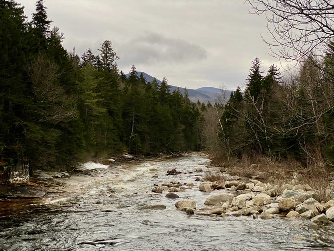
This short hike begins at the main trailhead for Lower Falls and follows the main path eastward as it runs alongside the Ammonoosuc River. The trail is very wide and appears to be used as a service road for official-use at times. The road passes through evergreens forests and eventually ends at Lower Falls Road not far down the trail. Lower Falls / Lower Ammonoosuc Falls is only a half-mile from the trailhead, which makes for an easy walk.
Lower Falls / Lower Ammonoosuc Falls - Mile 0.5
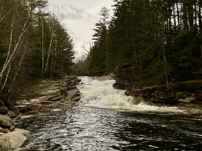
Hikers will reach a viewpoint of Lower Falls (Lower Ammonoosuc Falls) around mile 0.5. Here, you'll find a short rock scramble that leads down the banks of the river to get an unobstructed view of the waterfall - be careful if you descend the scramble as the rocks may be slippery if wet. Hikers will also get a view of the waterfall from on-trail as well, albeit a bit obstructed by the neighboring trees. Lower Falls is approximately 15-feet tall and spills down the Ammonoosuc River - during the Spring, snow melt from the Presidential Range (especially from the Ammonoosuc Ravine on Mt. Washington) causes water to surge through the river at rapid rates.
The hike out follows the same path in for an easy 1.1-mile out-and-back walk.
Parking
Hikers will find a very large parking lot at the coordinates provided, located on the north side of US-302 just east of Twin Mountain, NH. The lot is large enough to fit a few dozen vehicles.
Pets
Dogs are allowed only if leashed and must be cleaned up after.
Warning
Rock scramble: As stated previously, the best view of Lower Falls is from downstream along a rocky embankment on the side of the Ammonoosuc River. If you choose to scramble down the rocks, be careful especially during high water or if the rocks are slippery.
Trails
This hike follows one officially-named trail: Lower Falls Trail.
Hike
This short hike begins at the main trailhead for Lower Falls and follows the main path eastward as it runs alongside the Ammonoosuc River. The trail is very wide and appears to be used as a service road for official-use at times. The road passes through evergreens forests and eventually ends at Lower Falls Road not far down the trail. Lower Falls / Lower Ammonoosuc Falls is only a half-mile from the trailhead, which makes for an easy walk.
Lower Falls / Lower Ammonoosuc Falls - Mile 0.5
Hikers will reach a viewpoint of Lower Falls (Lower Ammonoosuc Falls) around mile 0.5. Here, you'll find a short rock scramble that leads down the banks of the river to get an unobstructed view of the waterfall - be careful if you descend the scramble as the rocks may be slippery if wet. Hikers will also get a view of the waterfall from on-trail as well, albeit a bit obstructed by the neighboring trees. Lower Falls is approximately 15-feet tall and spills down the Ammonoosuc River - during the Spring, snow melt from the Presidential Range (especially from the Ammonoosuc Ravine on Mt. Washington) causes water to surge through the river at rapid rates.
The hike out follows the same path in for an easy 1.1-mile out-and-back walk.
Parking
Hikers will find a very large parking lot at the coordinates provided, located on the north side of US-302 just east of Twin Mountain, NH. The lot is large enough to fit a few dozen vehicles.
Pets
Dogs are allowed only if leashed and must be cleaned up after.
Warning
Rock scramble: As stated previously, the best view of Lower Falls is from downstream along a rocky embankment on the side of the Ammonoosuc River. If you choose to scramble down the rocks, be careful especially during high water or if the rocks are slippery.