The Limahuli Gardens Loop at Limahuli National Tropical Botanical Garden near Hanalei, Hawaii (Kauai) is an easy 0.9-mile trail that passes through the beautiful Limahuli Preserve and features a self-guided tour of plants that encompass a living Hawaiian landscape along with beautiful views of the Limahuli Valley.
Hike Description
This trail begins just behind the gift shop, near marker #1. The trail includes 42 numbered points-of-interest along the route and each visitor is given a self-guided tour book which describes, in depth, what you're looking at. While our guide won't dive into every POI, there are a few worth noting, including a species of fern that's on the verge of extinction and one plant that grows in the reserve, but is actually extinct in the wild.
Trailhead to Mile 0.18
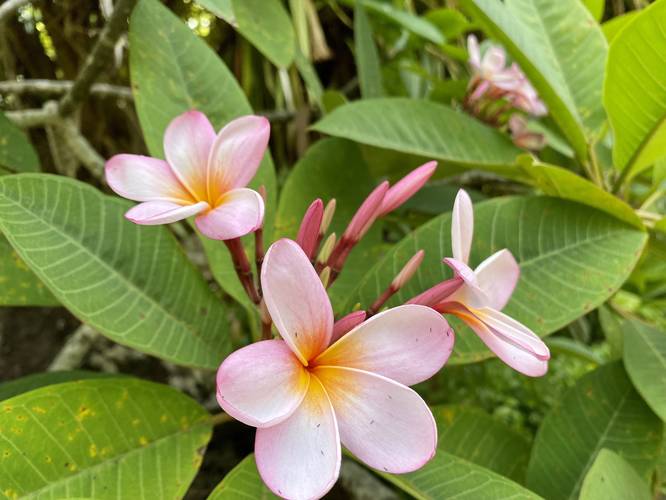
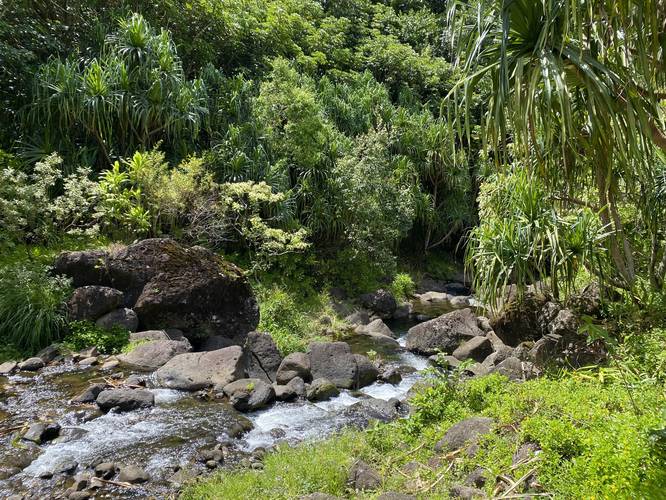
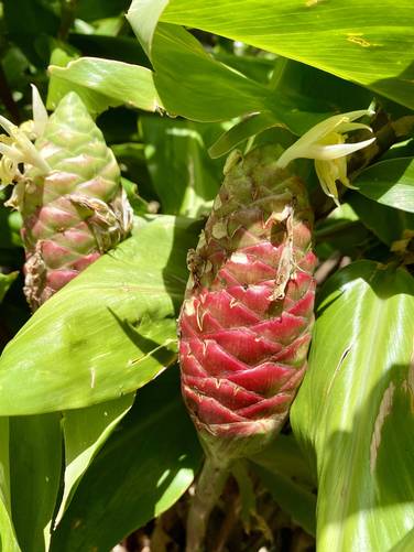
Between the start of the trail and mile 0.18, hikers will pass many points-of-interest before reaching a view point along Limahuli Stream. Along the way, hikers will find taro fields, canoe plants, ti plants, sugar cane, sweet potato, coconut palm, a medicine garden, and shampoo ginger before reaching the plantation garden at #14. The plantation garden includes plants like a plumeria tree, bird of paradise, and a mango tree. Right after existing the plantation garden, hikers will reach point-of-interest #18, which is the Limahuli Stream.
Limahuli Stream to Native Rainforest Walk - Mile 0.18 to 0.33
After passing the Limahuli Stream, the trail heads up the series of stairs, passing Hala trees along the way. At the top of this hill is the Native Rainforest Walk / Restoration area. Within the Native Rainforest Walk, hikers will find plants like the Loulu tree with its sprawling palm-like leaves. Additionally, the "Kauai digit fern" (Doryopteris angelica) can be found within this section of the trail. The Kauai digit fern, whose Hawaiian name has now been lost, is a threatened species in the wild because deer, pigs, and feral goats destroy most of these plants. Only a few Kauai digit fern plants remain in the mesic forests of West Kauai. Note that almost 90% of native Hawaiian flowering plants are endemic to Hawaii and some are endemic to only a small part of Hawaii, such as an island, valley, or mountain. Since Kauai is the oldest Hawaiian island, it also has more endemic species than any other Hawaiian island. The plants at Limahuli Garden are some of the rarest plants in the world and can only be found on Kauai; however, many of them are on the verge of extinction and some are already extinct in the wild - remaining only in cultivation at Limahuli Preserve.
Invasive Forest Walk - Mile 0.33 to Mile 0.42
Between miles 0.33 and 0.42, hikers will pass through the invasive forest walk which include species like the Umbrella tree and Autograph tree.
Native Plant Landscaping - Mile 0.45 to 0.55
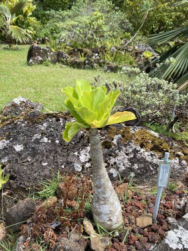
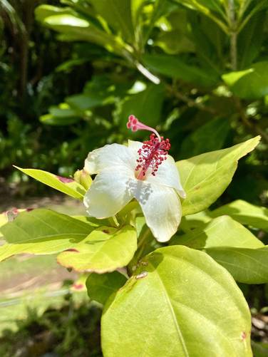
Around mile 0.45, after passing a nice view of the ocean, hikers will pass through landscaping that includes native plant species, some of which are extinct in the wild and only grow within the Limahuli Preserve. One plant that's extinct in the wild is the Alula (Brighamia insignis) which is a baseball-shaped plant with cabbage-like green leaves at the top. For more than two decades, staff members rappelled down cliffs on the Napali coast to monitor the wild populations of the Alula. Near the Alula is another species of plant that was once thought to be extinct, but was rediscovered in Limahuli Preserve in 1976 - the White Hibiscus, Koki'o ke'oke'o (Hibiscus waimeae ssp. hannerae). Last, the Iliau ('Iliau, Wilkesia gymnoxiphium) is also found in this garden - a plant that only grows on Kauai and stems from the same ancestor as Maui's Silversword, a tarweed from western North America.
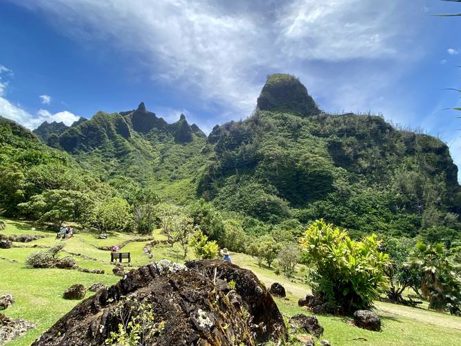
Limahuli Valley Views, 'Ohi'a lehua, Naupaka, Hale - Mile 0.55 to 0.75
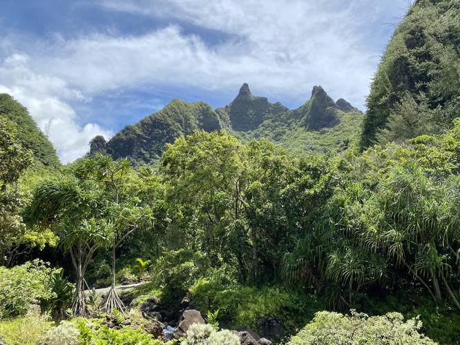
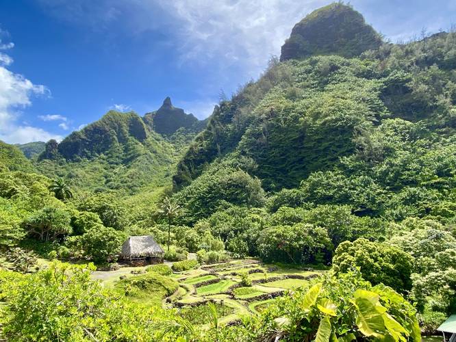
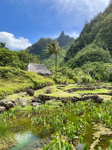
Between miles 0.55 and 0.75, hikers will pass views of Limahuli Valley which include towering mountains and taro fields below, 'Ohi'a lehua trees, Naupaka, and eventually reach a breadfruit tree (POI #41) and the Hawaiian Hale (house, POI #42) around mile 0.75. The views of the Limahuli Preserve are probably the best along the trail between miles 0.55 and 0.75, so they saved the best for last.
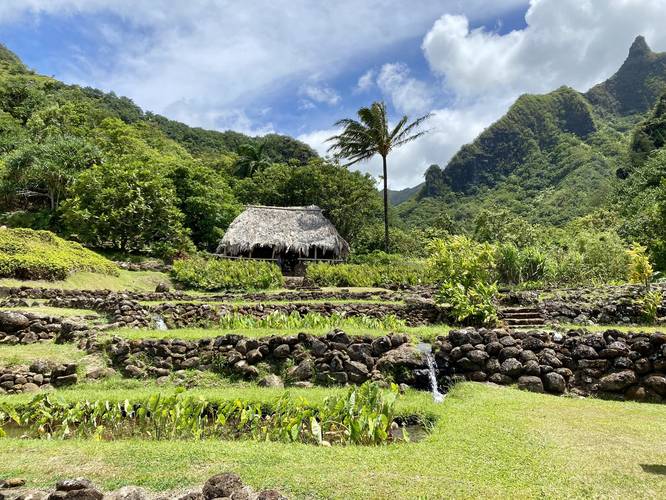
Hale, Taro Fields, Views, End of Trail - Mile 0.75 to 0.85
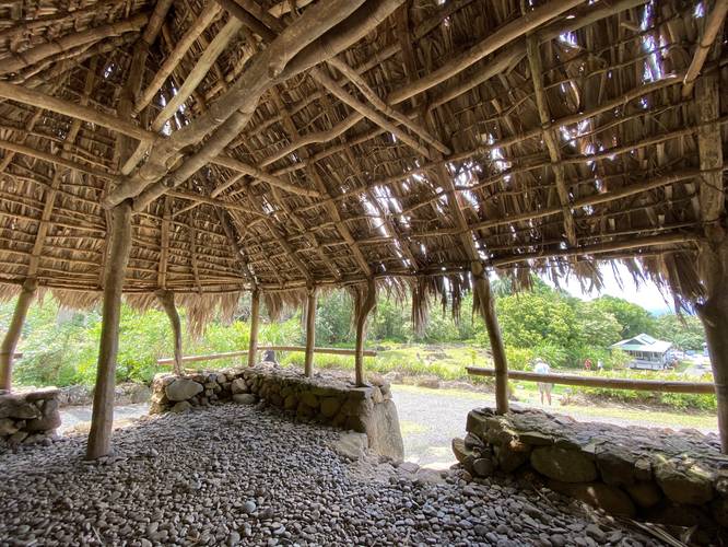
Finally, hikers will enter the Hale (POI #42) which is the last stop along the self-guided tour. This Hawaiian hale was reconstructed in the footprint of an ancient Hawaiian housing complex, which makes this stop along the route unique. This house is called a hale noa (house free from kapu) which means there are no strictly associated restrictions. There are cultural protocols, so if entering the hale please remove your shoes and visit quietly. It's been over 100 years since a traditional hale like this was last built in Ha'ena. This hale project was led by cultural elders and is deeply meaningful to present-day Hawaiians, as passed on the necessary knowledge to a new generation. After passing the hale, the trail will head down into the taro fields once more, crossing a small footbridge along the way. This is the last scenic stop along the trail before it ends, just below the gift shop.
Parking, Reservations, and Fees
Note that to visit Limahuli, as of July 2022, visitors will need to make a paid reservation on their website. The entrance fee is $25/adult. There's enough parking available for the reservation time slots.
Time to Hike
This trail is closer to a 50 minute walk if you plan to stop and read, take photos, and enjoy the scenery.
Pets
Dogs are not allowed.
Respecting the Land
Hawaiian land is considered sacred to native Hawaiians and many locals, so please stay on-trail, take nothing but photos, and leave nothing but footprints. Respect the locals - don't stay for long and have a backup hike planned in case the parking lot is full.
Hike Description
This trail begins just behind the gift shop, near marker #1. The trail includes 42 numbered points-of-interest along the route and each visitor is given a self-guided tour book which describes, in depth, what you're looking at. While our guide won't dive into every POI, there are a few worth noting, including a species of fern that's on the verge of extinction and one plant that grows in the reserve, but is actually extinct in the wild.
Trailhead to Mile 0.18
Between the start of the trail and mile 0.18, hikers will pass many points-of-interest before reaching a view point along Limahuli Stream. Along the way, hikers will find taro fields, canoe plants, ti plants, sugar cane, sweet potato, coconut palm, a medicine garden, and shampoo ginger before reaching the plantation garden at #14. The plantation garden includes plants like a plumeria tree, bird of paradise, and a mango tree. Right after existing the plantation garden, hikers will reach point-of-interest #18, which is the Limahuli Stream.
Limahuli Stream to Native Rainforest Walk - Mile 0.18 to 0.33
After passing the Limahuli Stream, the trail heads up the series of stairs, passing Hala trees along the way. At the top of this hill is the Native Rainforest Walk / Restoration area. Within the Native Rainforest Walk, hikers will find plants like the Loulu tree with its sprawling palm-like leaves. Additionally, the "Kauai digit fern" (Doryopteris angelica) can be found within this section of the trail. The Kauai digit fern, whose Hawaiian name has now been lost, is a threatened species in the wild because deer, pigs, and feral goats destroy most of these plants. Only a few Kauai digit fern plants remain in the mesic forests of West Kauai. Note that almost 90% of native Hawaiian flowering plants are endemic to Hawaii and some are endemic to only a small part of Hawaii, such as an island, valley, or mountain. Since Kauai is the oldest Hawaiian island, it also has more endemic species than any other Hawaiian island. The plants at Limahuli Garden are some of the rarest plants in the world and can only be found on Kauai; however, many of them are on the verge of extinction and some are already extinct in the wild - remaining only in cultivation at Limahuli Preserve.
Invasive Forest Walk - Mile 0.33 to Mile 0.42
Between miles 0.33 and 0.42, hikers will pass through the invasive forest walk which include species like the Umbrella tree and Autograph tree.
Native Plant Landscaping - Mile 0.45 to 0.55
Around mile 0.45, after passing a nice view of the ocean, hikers will pass through landscaping that includes native plant species, some of which are extinct in the wild and only grow within the Limahuli Preserve. One plant that's extinct in the wild is the Alula (Brighamia insignis) which is a baseball-shaped plant with cabbage-like green leaves at the top. For more than two decades, staff members rappelled down cliffs on the Napali coast to monitor the wild populations of the Alula. Near the Alula is another species of plant that was once thought to be extinct, but was rediscovered in Limahuli Preserve in 1976 - the White Hibiscus, Koki'o ke'oke'o (Hibiscus waimeae ssp. hannerae). Last, the Iliau ('Iliau, Wilkesia gymnoxiphium) is also found in this garden - a plant that only grows on Kauai and stems from the same ancestor as Maui's Silversword, a tarweed from western North America.
Limahuli Valley Views, 'Ohi'a lehua, Naupaka, Hale - Mile 0.55 to 0.75
Between miles 0.55 and 0.75, hikers will pass views of Limahuli Valley which include towering mountains and taro fields below, 'Ohi'a lehua trees, Naupaka, and eventually reach a breadfruit tree (POI #41) and the Hawaiian Hale (house, POI #42) around mile 0.75. The views of the Limahuli Preserve are probably the best along the trail between miles 0.55 and 0.75, so they saved the best for last.
Hale, Taro Fields, Views, End of Trail - Mile 0.75 to 0.85
Finally, hikers will enter the Hale (POI #42) which is the last stop along the self-guided tour. This Hawaiian hale was reconstructed in the footprint of an ancient Hawaiian housing complex, which makes this stop along the route unique. This house is called a hale noa (house free from kapu) which means there are no strictly associated restrictions. There are cultural protocols, so if entering the hale please remove your shoes and visit quietly. It's been over 100 years since a traditional hale like this was last built in Ha'ena. This hale project was led by cultural elders and is deeply meaningful to present-day Hawaiians, as passed on the necessary knowledge to a new generation. After passing the hale, the trail will head down into the taro fields once more, crossing a small footbridge along the way. This is the last scenic stop along the trail before it ends, just below the gift shop.
Parking, Reservations, and Fees
Note that to visit Limahuli, as of July 2022, visitors will need to make a paid reservation on their website. The entrance fee is $25/adult. There's enough parking available for the reservation time slots.
Time to Hike
This trail is closer to a 50 minute walk if you plan to stop and read, take photos, and enjoy the scenery.
Pets
Dogs are not allowed.
Respecting the Land
Hawaiian land is considered sacred to native Hawaiians and many locals, so please stay on-trail, take nothing but photos, and leave nothing but footprints. Respect the locals - don't stay for long and have a backup hike planned in case the parking lot is full.