Lehigh Gap Ridge via Appalachian Trail near Walnutport, Pennsylvania is a difficult 2.5-mile loop hike that features rock scrambles and stunning views of the Lehigh River Valley.
Trails
This hike follows two named trails: Appalachian Trail (white blazes), Winter Trail (blue blazes).
Hike
This hike begins at the eastern parking lot for the Appalachian Trail located at the parking coordinates provided. The AT can be found on the northern side of the parking lot, where this hike begins.
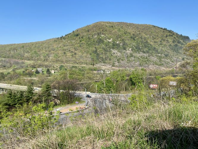
Kittatinny Ridge View - Mile 0
At the trailhead, hikers have to option to explore a valley view of the Kittatinny Ridge located on the west side of the Lehigh Gap by following a short off-trail path. You'll also find signage with trail information along the way.
AT Junction - Mile 0.1
After checking out the short Kittatinny Ridge view stop, hikers will find a trail junction at mile 0.1 - this is the continuation of the Appalachian Trail. During warm months, when no ice/snow is built up on the ridge, you'll want to hike up the AT to avoid any downhill scrambles you would encounter by hiking the Winter Trail first. The hike along the AT is uphill the entire way until you reach the top of the mountain, so the difficult terrain begins here.
Boulder Fields Begins - Mile 0.3
Around mile 0.3, hikers will encounter the first terrain change where the trail switches from being a bit rocky to full-on boulder field / rock field traversing. The first couple of sections is mostly rock fields - smaller rocks that can be easily walked along or over. Later on that changes a bit.
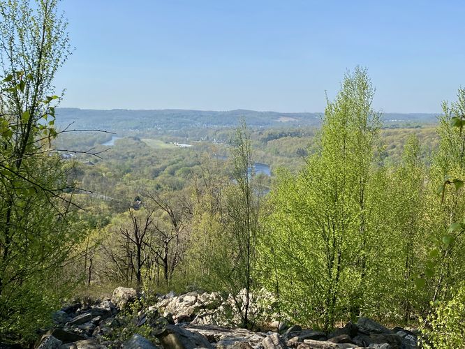
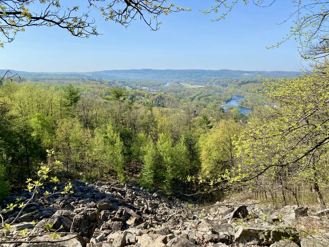
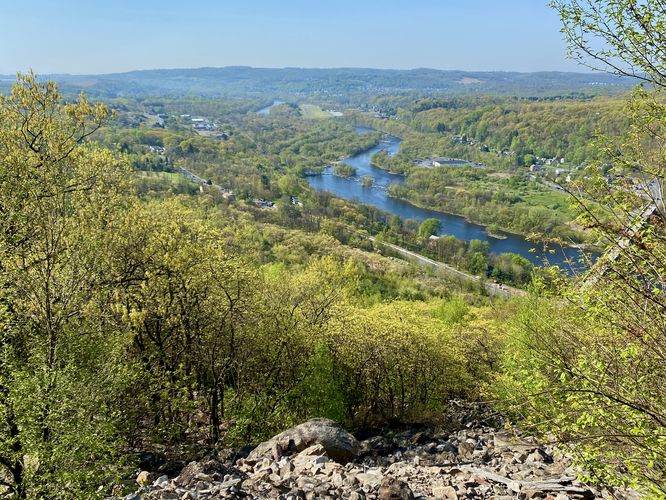
Southern Lehigh River Valley Views - Mile 0.35
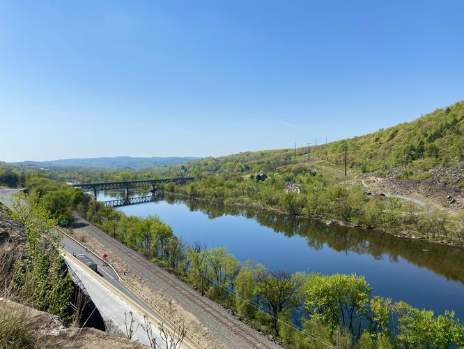
After the first rock field, hikers will find a couple of viewpoints of the Lehigh River Valley - both south facing. One can be found around mile 0.35 and another around mile 0.38.
Boulder Field & Views - Mile 0.5
Hikers will reach another rock slide on the mountain slopes around mile 0.48 and will have to traverse over a couple of large boulders to continue along the AT. Just uphill from the rock slide area is a beautiful view of the Lehigh River Valley - facing southward - with the boulder field below your feet. This is a nice spot to take a break, especially since you'll find scraps of neighboring shade if hiking earlier in the day.
Scrambles & Views - Mile 0.52 to 0.6
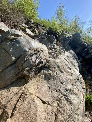
Just beyond the larger boulder field outcropping is where the rock scrambling begins. Hikers will find the first scramble around mile 0.52 which is about a 8 to 10-foot pitch up along several tiers of rocks. The first scramble isn't hard but can be annoying in spots. The 2nd scramble is a lot more open and wide, providing you with options to make it up several different ways - this one is not very difficult, but there's less to hold on to for safety. The 3rd scramble is the most dangerous as it heads up and around a cliff in the bedrock at a steeper slope. The easiest way to traverse the 3rd scramble is by embracing the cliff's edge as it provides more hand and foot holds. Last, hikers will reach a tall rock outcropping with the 4th and last rock scramble located around mile 0.6, which leads up to the mountain ridge. These scrambles can be tricky if hiking with trekking poles. Don't forget that along the scrambles are beautiful views of the Lehigh River and even the Lehigh Gap surrounding you.
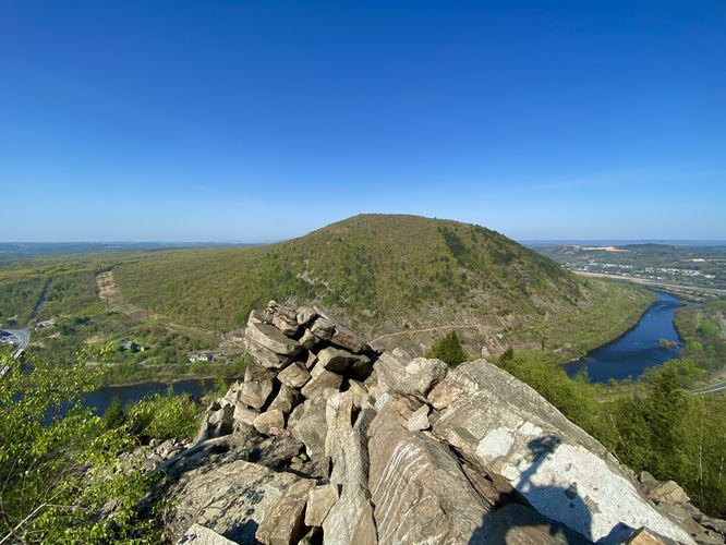
Ridge Traverse & Views - Mile 0.6 to 0.75
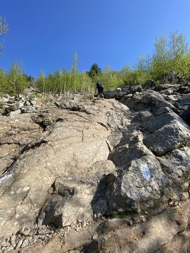
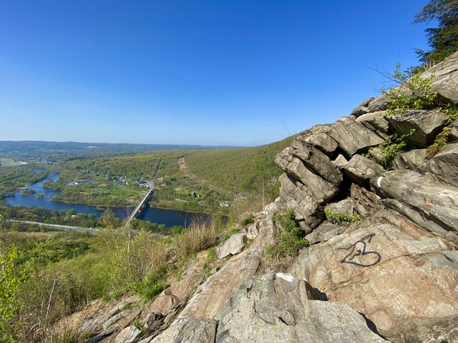
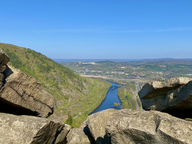
Hikers will reach the top of the mountain ridge around mile 0.6 or just beyond after the 3rd scramble. You know you're at the top once you scramble your way up the 4th scramble along large boulders. Once on the ridge, you'll find stunning views of the Lehigh Gap and Lehigh River. Most of the views from the ridge are west or north facing so you can see the entire Lehigh Gap and into the town of Palmerton, PA. Once on the ridge, you'll find plenty of viewpoints but also difficult terrain to traverse. The ridge is made-up of large boulders, so you must continue scrambling or traversing rocks very slowly to ensure your safety. The AT hops up and down these boulders, so it's not a steady climb up the ridge but rather an undulating one. Hikers will finally make it to the "other side" of the boulders and mountain ridge around mile 0.75, where the trail becomes a lot more forgiving. Remember to check out the views and take-in the scenery while on the ridge, but keep in mind that this area is prone to rock slides.
Once out of the mountain ridge area, the hike toward the Winter Trail is a steady uphill hike, but is much easier than the rock/boulder traversing you just completed.
Winter Trail Junction - Mile 0.9
Around mile 0.9, hikers will reach the "top" of the mountain's western slopes in the Lehigh Gap and also where the AT meets up with the Winter Trail (blue blazes). Here, take a left-hand turn and follow the blue blazes of the Winter Trail back to parking.
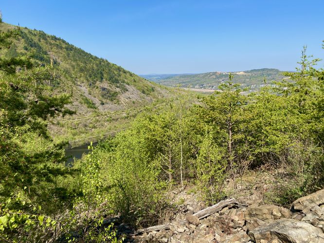
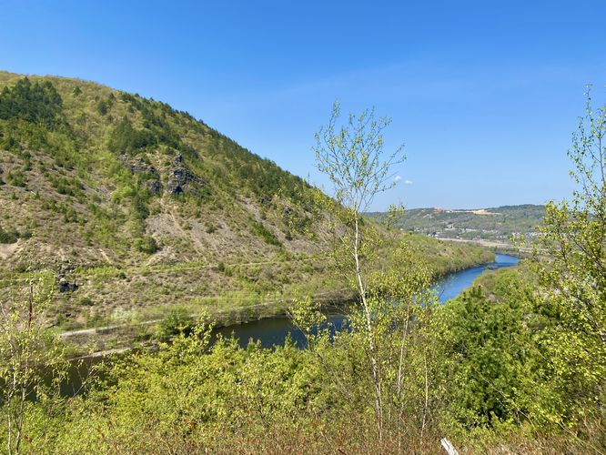
Winter Trail - Mile 0.9 to 2.5
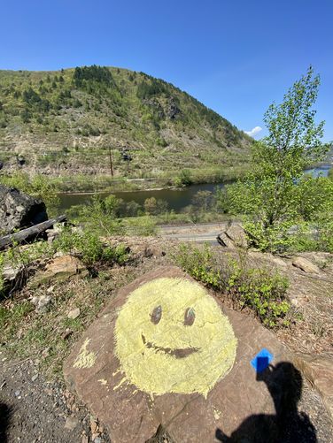
Hikers will spend most of their mileage along the Winter Trail as it winds its way down the mountain's western slopes while following long switchbacks. The trail does not have much to offer hikers in the higher elevations, but as you make your way down closer to the bottom of the mountain, you'll find a couple of viewpoints like at mile 1.6 and 1.7 - both views are northwest facing into the Lehigh Gap with some views of the Lehigh River. "Smiley face rock", a graffiti rock, can be found around mile 1.75 once you reach the flat portion of the trail. Once on the flat section of the Winter Trail, hikers will make their way past the rock slide zone as the trail passes along cliffs and massive boulders that have fallen down the mountain. Last, around mile 2.2 is a nice south facing view of the Lehigh River from the cliff's edge.
Finally, hikers will reach the parking lot around mile 2.5 to complete the loop.
Parking
Hikers will find a large parking lot at the coordinates provided, located on the east side of the Lehigh River and north of the PA-145 and PA-248 highway junctions. The lot is large enough to fit a couple dozen vehicles and includes some overflow parking along the side of the entrance road, closer to the main lot.
Pets
Dogs are allowed only if leashed and must be cleaned up after. Note that due to the rock scrambles, this hike may be difficult for smaller dogs.
Warnings
Steep terrain, scrambles, cliffs: This hike passes through boulder fields and steep mountain ridge terrain that forces you to scramble uphill along bedrock. Some of the bedrock scrambles include short cliffs; however, if you accidentally fall, you may tumble down the bedrock further. This terrain must be traversed slowly and only by hikers who feel comfortable and confident enough to do so. Hike at your own risk.
Timber rattlesnakes: While more rare in this part of Pennsylvania, the Timber Rattlesnake does live in the state and could be roaming the forest between the end of April and early October each year. Be on the lookout and give any rattlers you find plenty of space.
Rock slides: This trail passes through boulder areas that are prone to rock slides. In these sections, it's best to keep moving as you never know when or where a rock slide could occur next.
Trails
This hike follows two named trails: Appalachian Trail (white blazes), Winter Trail (blue blazes).
Hike
This hike begins at the eastern parking lot for the Appalachian Trail located at the parking coordinates provided. The AT can be found on the northern side of the parking lot, where this hike begins.
Kittatinny Ridge View - Mile 0
At the trailhead, hikers have to option to explore a valley view of the Kittatinny Ridge located on the west side of the Lehigh Gap by following a short off-trail path. You'll also find signage with trail information along the way.
AT Junction - Mile 0.1
After checking out the short Kittatinny Ridge view stop, hikers will find a trail junction at mile 0.1 - this is the continuation of the Appalachian Trail. During warm months, when no ice/snow is built up on the ridge, you'll want to hike up the AT to avoid any downhill scrambles you would encounter by hiking the Winter Trail first. The hike along the AT is uphill the entire way until you reach the top of the mountain, so the difficult terrain begins here.
Boulder Fields Begins - Mile 0.3
Around mile 0.3, hikers will encounter the first terrain change where the trail switches from being a bit rocky to full-on boulder field / rock field traversing. The first couple of sections is mostly rock fields - smaller rocks that can be easily walked along or over. Later on that changes a bit.
Southern Lehigh River Valley Views - Mile 0.35
After the first rock field, hikers will find a couple of viewpoints of the Lehigh River Valley - both south facing. One can be found around mile 0.35 and another around mile 0.38.
Boulder Field & Views - Mile 0.5
Hikers will reach another rock slide on the mountain slopes around mile 0.48 and will have to traverse over a couple of large boulders to continue along the AT. Just uphill from the rock slide area is a beautiful view of the Lehigh River Valley - facing southward - with the boulder field below your feet. This is a nice spot to take a break, especially since you'll find scraps of neighboring shade if hiking earlier in the day.
Scrambles & Views - Mile 0.52 to 0.6
Just beyond the larger boulder field outcropping is where the rock scrambling begins. Hikers will find the first scramble around mile 0.52 which is about a 8 to 10-foot pitch up along several tiers of rocks. The first scramble isn't hard but can be annoying in spots. The 2nd scramble is a lot more open and wide, providing you with options to make it up several different ways - this one is not very difficult, but there's less to hold on to for safety. The 3rd scramble is the most dangerous as it heads up and around a cliff in the bedrock at a steeper slope. The easiest way to traverse the 3rd scramble is by embracing the cliff's edge as it provides more hand and foot holds. Last, hikers will reach a tall rock outcropping with the 4th and last rock scramble located around mile 0.6, which leads up to the mountain ridge. These scrambles can be tricky if hiking with trekking poles. Don't forget that along the scrambles are beautiful views of the Lehigh River and even the Lehigh Gap surrounding you.
Ridge Traverse & Views - Mile 0.6 to 0.75
Hikers will reach the top of the mountain ridge around mile 0.6 or just beyond after the 3rd scramble. You know you're at the top once you scramble your way up the 4th scramble along large boulders. Once on the ridge, you'll find stunning views of the Lehigh Gap and Lehigh River. Most of the views from the ridge are west or north facing so you can see the entire Lehigh Gap and into the town of Palmerton, PA. Once on the ridge, you'll find plenty of viewpoints but also difficult terrain to traverse. The ridge is made-up of large boulders, so you must continue scrambling or traversing rocks very slowly to ensure your safety. The AT hops up and down these boulders, so it's not a steady climb up the ridge but rather an undulating one. Hikers will finally make it to the "other side" of the boulders and mountain ridge around mile 0.75, where the trail becomes a lot more forgiving. Remember to check out the views and take-in the scenery while on the ridge, but keep in mind that this area is prone to rock slides.
Once out of the mountain ridge area, the hike toward the Winter Trail is a steady uphill hike, but is much easier than the rock/boulder traversing you just completed.
Winter Trail Junction - Mile 0.9
Around mile 0.9, hikers will reach the "top" of the mountain's western slopes in the Lehigh Gap and also where the AT meets up with the Winter Trail (blue blazes). Here, take a left-hand turn and follow the blue blazes of the Winter Trail back to parking.
Winter Trail - Mile 0.9 to 2.5
Hikers will spend most of their mileage along the Winter Trail as it winds its way down the mountain's western slopes while following long switchbacks. The trail does not have much to offer hikers in the higher elevations, but as you make your way down closer to the bottom of the mountain, you'll find a couple of viewpoints like at mile 1.6 and 1.7 - both views are northwest facing into the Lehigh Gap with some views of the Lehigh River. "Smiley face rock", a graffiti rock, can be found around mile 1.75 once you reach the flat portion of the trail. Once on the flat section of the Winter Trail, hikers will make their way past the rock slide zone as the trail passes along cliffs and massive boulders that have fallen down the mountain. Last, around mile 2.2 is a nice south facing view of the Lehigh River from the cliff's edge.
Finally, hikers will reach the parking lot around mile 2.5 to complete the loop.
Parking
Hikers will find a large parking lot at the coordinates provided, located on the east side of the Lehigh River and north of the PA-145 and PA-248 highway junctions. The lot is large enough to fit a couple dozen vehicles and includes some overflow parking along the side of the entrance road, closer to the main lot.
Pets
Dogs are allowed only if leashed and must be cleaned up after. Note that due to the rock scrambles, this hike may be difficult for smaller dogs.
Warnings
Steep terrain, scrambles, cliffs: This hike passes through boulder fields and steep mountain ridge terrain that forces you to scramble uphill along bedrock. Some of the bedrock scrambles include short cliffs; however, if you accidentally fall, you may tumble down the bedrock further. This terrain must be traversed slowly and only by hikers who feel comfortable and confident enough to do so. Hike at your own risk.
Timber rattlesnakes: While more rare in this part of Pennsylvania, the Timber Rattlesnake does live in the state and could be roaming the forest between the end of April and early October each year. Be on the lookout and give any rattlers you find plenty of space.
Rock slides: This trail passes through boulder areas that are prone to rock slides. In these sections, it's best to keep moving as you never know when or where a rock slide could occur next.